
At the beginning of August, it was time for the first multi-day, cross-Europe flying trip. Arvind, an old friend from high school and other deeds, and I had about ten days to fill with maximum adventure and distraction. At first, I suggested a flying trip with an undefined destination, basically sailing with the clouds and seeing where the weather would take us day-by-day. But soon enough, I started making plans A, B, C… – paying tribute to the fact that flying somewhere under visual flight rules in Europe involves a certain amount of planning and cannot realistically be done completely ad-hoc. Although efforts are being made to harmonize flying regulations across the European Union – the Standardized European Rules of the Air (SERA) – there’s a lot of variation between countries and it is good advice to spend some time reviewing the local peculiarities of a country or airport you want to fly to.
The more evenings I spent drafting plan A (and talking about it to people) the clearer it became that we were not interested in plans B, C, … anymore. We had found our destination: We were going to fly to the Balkans! It helped that we both had not been to most of the enroute places we had in mind and that we also share a passion for Balkan Pop, although we were aware that this is a local phenomenon in Germany and few people in South-Eastern Europe would even know this.
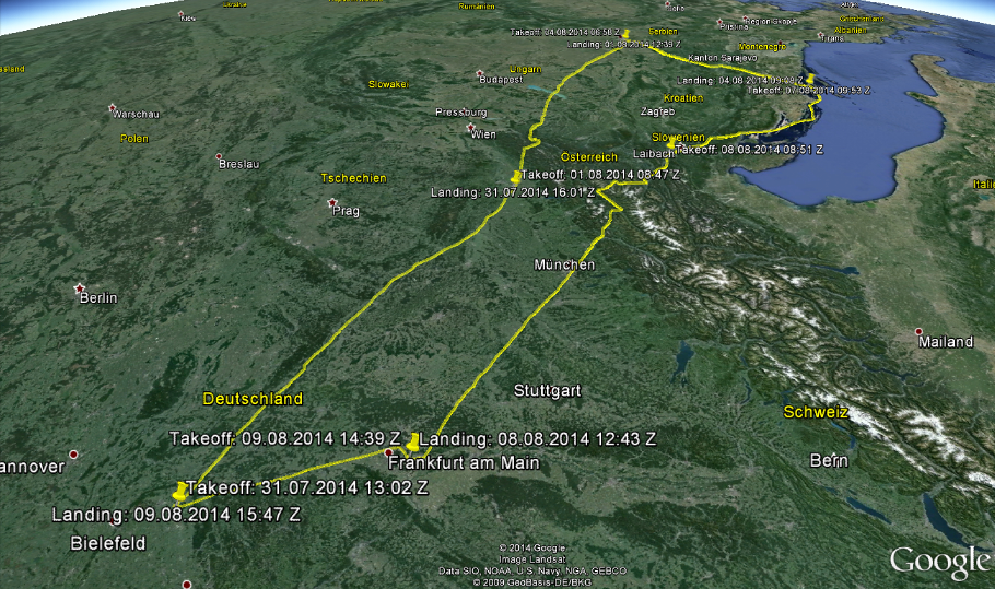
So – bar the unlikely event of totally unflyable weather in the South-East, our plans became clearer and clearer. The initial route covered Budapest, Belgrade, Sarajevo, the Adriatic coast of Croatia and/or Montenegro, Zagreb and/or Ljubljana. We ended up dropping Budapest, Montenegro, and Zagreb from the plan (mostly due to time limitations) and couldn’t fly into Sarajevo due to a solid cloud cover over the Sarajevo valley. Without giving away too much from the details below, all other destinations were reached as planned. We didn’t have to deal with a single weather-related delay or diversion on the entire trip – quite exceptional for VFR touring in Europe, I should like to think!
Here’s some key data on the trip:
• Aircraft: Originally planned with a two-seat Cessna 152 rented from FFL in Essen-Mülheim, we later changed to a club-owned four-seat Cessna 172 M with SuperPlus 98 certification and long-range tanks (181 liters) from Paderborn-Lippstadt. I specifically became member of the club there (www.lsvr.de) for the purpose of this trip. I’m not a club-type person, but it made economic sense as the hourly wet rate of only 120 EUR (!) in addition to the membership fees for a year was still much cheaper than the commercial charter of a C152. The larger aircraft allowed the two of us to take more baggage and still fill up both tanks fully and fly long legs of up to 5 hours (or until you really need to relieve your bladder, whichever comes first). The longest leg actually flown was 4 hours.
• Total track made good: 1573 nautical miles/2913 kilometers
• Total flying time: 16,6 hours
• Total fuel consumption: 567 liters
• Total Whisky and Wine consumption before non-flying days: open to your imagination
• Flying highlights: Two Alps crossings, my longest and highest flight, largest airport landed at, mountain flying over Bosnia, flying along the Adriatic coast in Croatia, flying over Munich
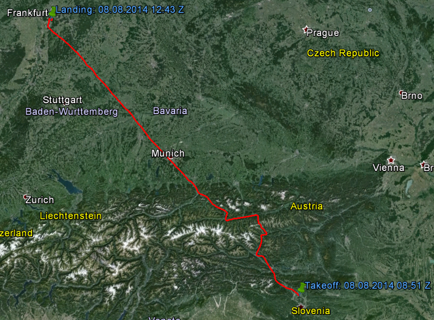
Flying leg: Paderborn/Lippstadt (EDLP) – Wels Weiße Möwe (LOLW)
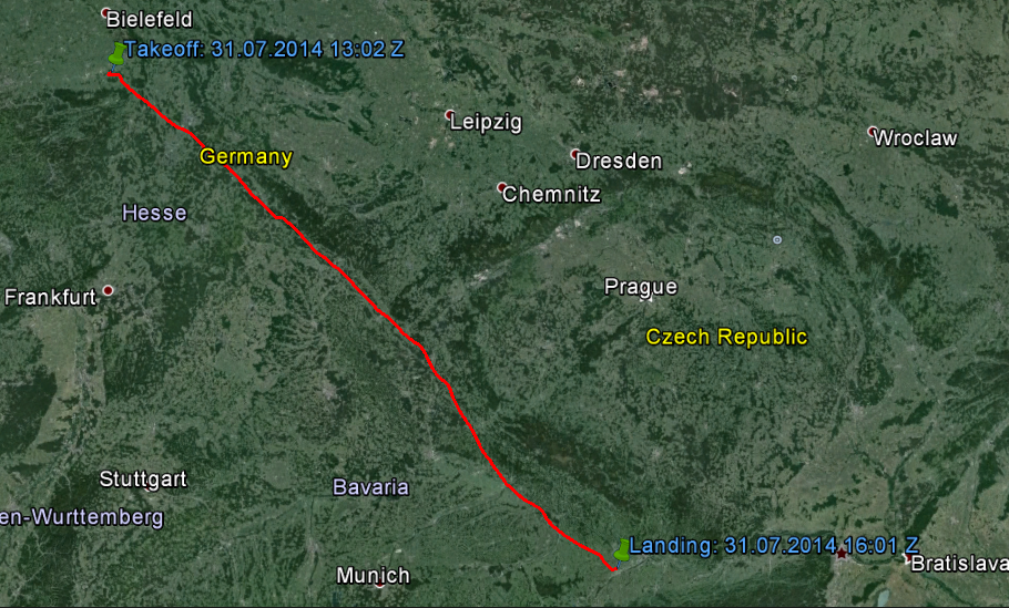
On the 1 1/2 hour rental car trip from Düsseldorf to Paderborn, it became clear that we were about to fly towards the only region in Europe on that day with marginal weather. We decided that we would fly as far south as possible in good conditions to profit from the improving weather outlook for the next morning and the potential crossing of the Eastern Alps. After checking all weather data (METARs, TAFs, GAFOR, radar, satellite), we identified Deggendorf (EDMW) as a good start. It was also the first of many times we’d see the Danube on our way south. This airfield is PPR, which means you are required to obtain a permission prior to flying here. That’s because the “Flugleiter” (a German anomaly which requires all aerodromes to be manned during operational hours) might not be there at all times but will come to the airfield if notified before your arrival. I called the PPR number and spoke with a lady who took my details and said everything was fine. In fact, nothing was fine: After a generally uneventful flight, I tried calling Deggendorf Info on the radio seven times without any success. There was no-one to be spoken with. In any normal country, I suppose I could have just landed, but not in Germany. So flying overhead the field, we aborted our approach, called up München Information again (who we had just thanked for their service and said good-bye to) and discussed our options. I was under the impression that a flight plan is needed for any border-crossing flight and asked the lady on frequency if we could create a flight plan ad-hoc and proceed to Austria (after having checked the current METAR for Linz, which was fine). However, I learned that only for flights intro controlled airspace a flight plan is required to cross the border to Austria (“because the Austrians are our friends!”). That ruled out Linz (LOWL) but allowed us to fly to Wels (LOLW). Thankfully, I had already prepared the approach to Wels and we had the printed visual charts accessible – so off we went to Austria. We entered LOLW downwind for runway 09 with some light drizzle – it only really poured down heavily once I had left the airplane to refuel and push it to the hangar with the help of one of the guys from the airfield. Completely soaked, we ordered a taxi into town to the hotel for which we still had a reservation (we had made several cancelable reservations in various cities).
Destination: Wels, Austria
No offense to anyone from Wels, but the city lives a sad life in the shadow of neighboring Linz. The constant drizzle didn’t help and our impression of downtown Wels was a little dull. It also didn’t help that the “free minibar” promised with our hotel room contained nothing more than two bottles of water. Initially. We managed to get a refill with some more bottles of water and lemonade later on. We did have a very nice and filling dinner in a rustic Austrian restaurant, though. The waitresses were beastly charming – especially the one that had to deal with the large Russian table in the corner (She actually rolled her eyes at us and said “They’re hell!” and we wondered what she told them about US when she wasn’t facing us…).
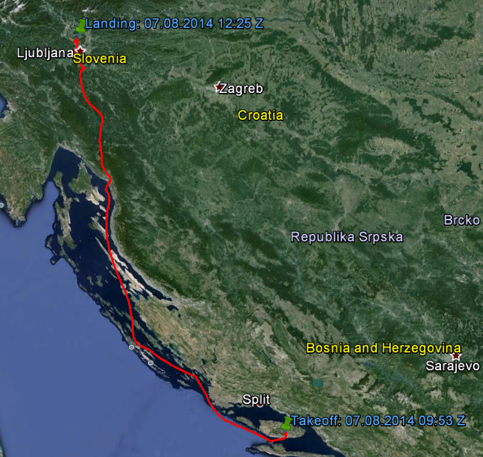
Flying Leg: Wels Weiße Möwe (LOLW) – Beograd Nikola Tesla Airport (LYBE)
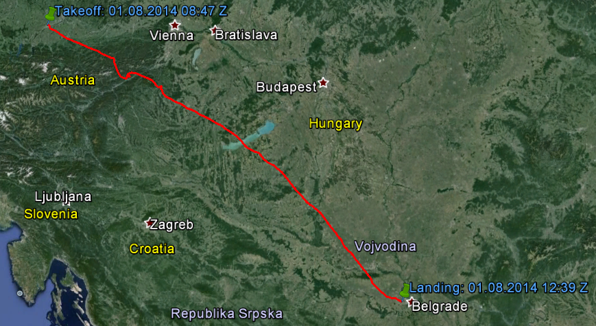
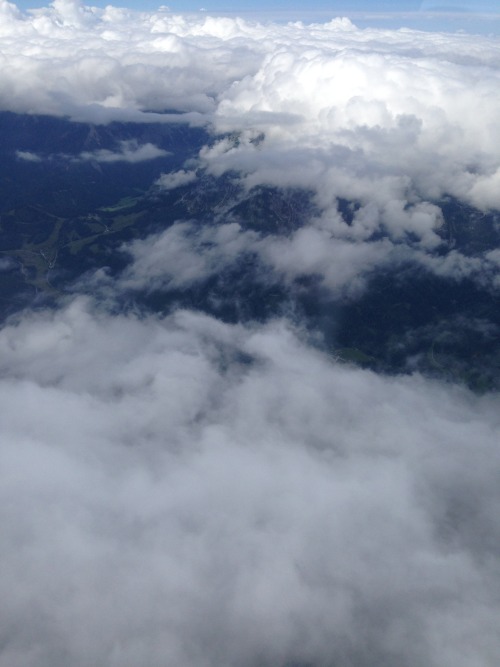
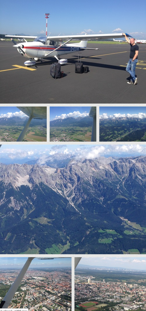
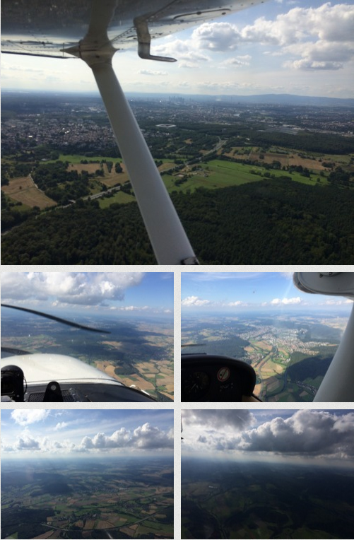
The prospect of crossing the Alps the next morning made me a bit nervous. It is one of these things that are hard to judge if you haven’t done it before. The advice I received ranged from “Don’t do it until you’ve done it at least six times with an instructor!” to “It’s a complete non-event – so long as you fly ABOVE the mountains rather than IN the valleys!”. I somehow had to find my balance between the two: I had no intention to fly low in the valleys, but also no aircraft capable of flying at terribly high altitudes (to fly substantially ABOVE all mountain tops in this region, you need at least a turbo-charged airplane and if you wanted to stay awake and on top of your mind while doing this, you’d also need some sort of oxygen supply – neither of which we had). The entire plan was built on the idea to cross the Alps in the Eastern-most part with rather less intimidating mountain tops than if you look further west. Another precondition was fair weather and the availability (in terms of cloud layers) of a save altitude of at least 8500 ft. The terrain elevation on our planned route via Mariazell, Lanzen/Turnau and Pinkafeld was peaking at 6500 ft. This gave us a pretty good margin of 2000 ft to cope with any down drafts that we might encounter.
What makes mountain flying (i.e. flying low in the valleys) so difficult in my view is mostly two categories of factors: Weather-related and navigation related. The weather phenomena you may encounter in the mountains are diverse and should not be taken light-hearted. There is a basic, but good metaphor that helps visualize what air does when it meets terrain: Air, like other fluids in many ways behaves like water. As air flows, say, from North to South over the Alps or vice versa, picture it like a flow of water (for example, after a broken reservoir dam) and imagine you’re somehow trying to navigate a tiny airplane (submarine?) within that flow, preferably without hitting terrain. You’re going to go with the up- and downdrafts no matter what, but the art is to know where they are more or less likely/dangerous, how to get out of there in time if it gets dangerous and what to do when you’re in them. Navigation within valleys is also not straight-forward. You might end up in the wrong valley (quicker than you think) and if that valley narrows and the top is covered by cloud, you might just pass that point of no return where you simply cannot maneuver the aircraft to turn back and you are going to end up as another case of “Controlled Flight Into Terrain” – one of the most frequent accident causes in small aeroplanes.
So I wanted none of that and fly as high above as possible (although I tried to prepare myself by reading up on how to fly in the mountains just in case we were forced to fly lower by whatever unforeseen factor). I frantically checked the weather the night before the flight, in the morning in bed, during the taxi ride to the airfield, at the airfield, … to the point that Arvind was getting a little annoyed, just wanting to get going… I had wanted to back up this weather briefing with a call to the MET office and speak to a meteorological consultant in person – but to my dismay, there was no way to dial their (toll) number from our German cell phones. In the end, I decided to give it a go. Reported winds aloft weren’t too bad and the pressure differential between the North and the South sides of the Alps wasn’t worrying, either. There were some cloud layers but I suspected we could climb on top and fly there. As our “easy way out” in case the plan didn’t work, we could always have turned around and gone back to Wels to reconsider. Our alternative (but less exciting) route for less than optimal conditions via Vienna over mostly flat land would have only cost us half an hour of flying time.
We announced our departure to Serbia at the C Office in Wels. There was a bit confusion as to whether a police/customs notification was necessary. It didn’t help that we had trouble understanding the thick Austrian accent and the guy had trouble understanding us. I thought it should be clear, as Serbia is not a EU/Schengen country. A quick call to the police (in Linz, I suppose) revealed that they had no intention of coming out to see us for our little private flight to Belgrade. On departure, there was a funny moment when I announced our departure on the radio in German and the guy at the ground station (same as the one we had the police/no police discussion with) said: “Could we please switch to English, I have no idea what you’re saying in ‘Hochdeutsch’”.
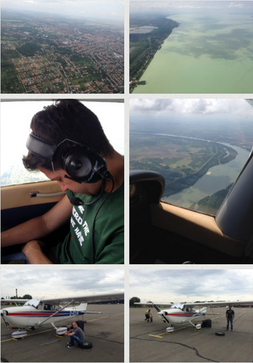
At the end of the day, the Alps on this flight WERE mostly a non-event. We easily found holes in the scattered cloud base to climb through – before we even saw any mountains. In fact, on this flight we didn’t see a lot of mountains at all, as they were mostly hidden by cloud. Towards the end of the crossing, just east of Lanzen/Turnau – we had climbed up to Flight Level 105 by then to avoid higher cloud tops – I was able to demonstrate to my passenger what inadvertent entry into cloud means. When I told him before, he didn’t believe me that it would be a problem – but after this brief encounter, he said it was the scariest part of the entire flying trip. We had lost touch with Wien Information a few minutes ago and were only expecting to be back under radio coverage at the next waypoint a couple of miles ahead. We were alone. What happened is that we came into a situation where we couldn’t quite out climb a cloud ahead of us and though I tried to avoid it, we were “in” it quicker than expected. I did what every PPL student learns: Initiate a 180° turn right away based on instruments and get out there. After all, you KNOW what’s behind you because that’s where you’re coming from and you’re save there – but you have no idea what’s ahead of you in that cloud (more cloud? icing? a mountain? an airplane?). It only took seconds but felt longer to both of us and I believe we were both a bit uneasy with the situation. Once clear, we altered our course to avoid this field of higher clouds and managed to get out without any further problems. Soon after the terrain became flat again, we descended in a spiraling turn through a large hole ahead of us below the cloud layer and continued our flight at lower altitudes of 2000-4000 ft. We could have stayed up high – but at SOME point before Belgrade we needed to descend and I thought let’s do it rather sooner than later – with the added advantage of allowing for some sight-seeing in Hungary, which was next.
Granted, the sights along our route in Hungary were limited – though once we crossed the border from Austria to Hungary, we looked at the towns below us and noticed the immediate difference in architectural style. The lady from Budapest Information we spoke with on our journey through this country was nice and professional, as expected. The most interesting ground feature was the crossing of Lake Balaton, the largest lake in Central Europe and one of Hungary’s major tourist destinations.
Crossing the border to Serbia at IFR reporting point BABIT (just east of the Danube river and the border to Croatia), we were confronted with a major change in “flying style” that would be with us until the last day of our journey. All countries on our route (until back in Austria) do not allow uncontrolled visual flying as is the usual practice in large parts of the lower airspace in Western Europe. Upon handover from Budapest Information to Beograd Approach, we were theoretically under ATC control – i.e. flying assigned headings and altitudes. In fact, for the first 10-15 minutes in Serbia we had trouble establishing two-way radio communication (“… read you three…”) and were only later called back with a squawk code and a clearance to proceed visually to OBR NDB at 2000ft. Upon reflection, I’m not sure I should have proceeded after the border without that clearance in the first place. But I have to say, the chap at Beograd Approach was very relaxed and extremely helpful. Though he was busy coordinating all sorts of flights (mostly Air Serbia), he offered a lot of proactive assistance and gave us generous clearances to choose altitudes at our own discretion (within limits) to stay below varying cloud bases. One time, when I was letting the altitude loose a bit, I received an immediate “D-VK, confirm you’re maintaining 2,000 ft, Sir”. He often asked if we have ground contact (i.e. the surface in sight) and “D-VK, are you familiar with this area, or that area, watch out here, etc”. He also warned us of a singular mountain ahead with antennas on top and even offered us to avoid that mountain completely by flying a different approach to Beograd via the North-East and VRP Yabuk. I declined because I didn’t regard that mountain as a major problem and after a long and tiring flight, I wasn’t in the mood for unplanned changes anyway. Again, we received a very generous clearance to select heading and altitude at our own discretion to clear the ridge while avoiding cloud. Once clear of terrain, we received several “direct-to” headings that eventually established us smoothly on final for runway 12 of Beograd Nikola Tesla Aeorodrome with a luxurious LDA (Landing Distance Available) of 3400 meters (at a width of 45 meters). In the Garmin GNS 430 GPS that we had installed in the cockpit (and other aviation GPS products, too, for that matter) you can either enter your entire flight plan as a series of way points or you can fly directly to a single way point on a straight line by entering and activating it. It is often said that low hour pilots only know how to use such direct-to’s and don’t know how to use the full potential of the product. On this flight, I realized there is a very pragmatic reason for using direct-to’s only, even if you know the tedious procedure to enter a full flight plan. Chances are it will become invalid quickly, when ATC issues a slightly different routing for you or gives you shortcuts – all the hard, knob-turning work in vain!
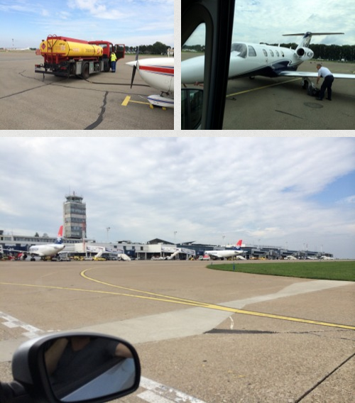
After clearing the runway, we were picked up by a follow-me car and marshalled into our parking position. Once the engine was shut, the friendly handling agent came to greet us: “Welcome to Serbia!”. The aircraft was tied-down by ground staff immediately. Unfortunately, the fuel truck was busy at the time and as I wanted to refuel upon arrival whenever possible (to save time in the morning when departing), we had to wait for about half an hour. We were invited to wait in the General Aviation lounge where we spent the time talking to the German First Officer of a Cessna Citation. He was actually an AirBerlin pilot flying A320 and doing business charter flights like this one to Belgrade on his days off. It was nice to see the sparkle in his eyes when we told him about our trip. Certainly a different kind of flying from his everyday job. Once again, this proved to me that I’d never want to be an airline pilot for a living. I want flying to be adventurous and exciting for the rest of my life and not become a daily routine.
After refueling (for ridiculously cheap 1,15 EUR/liter), I was driven back to the GA Terminal and after passing passport control, we hired a pink cab (those are the ones you can trust in Belgrade, like Rheintaxi in Düsseldorf) and were off to explore an exciting city… By the way, it is officially required to make contact with LYBE a set amount of hours before planned arrival via email. I sent them four emails without any response. I don’t think they really care about those emails, though I’d still send one next time I fly there (but I won’t expect a response).
Destination: Belgrade, Serbia
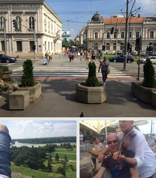
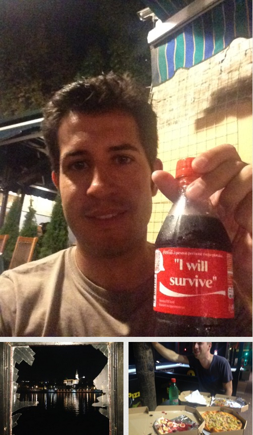
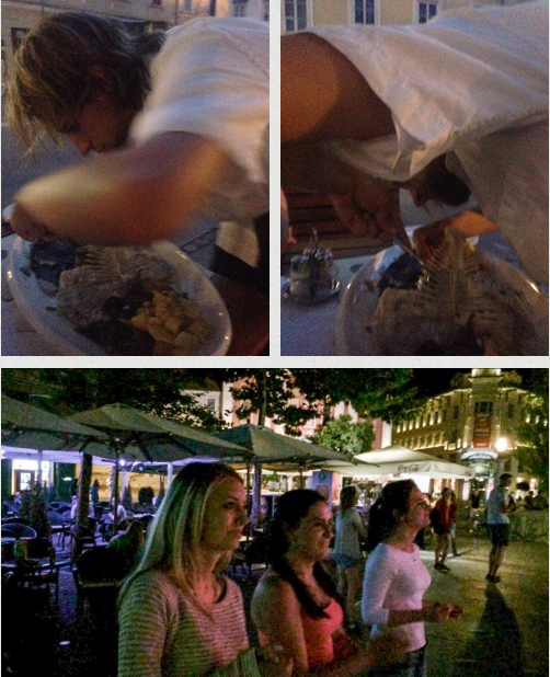
Belgrade is a fabulous city! It’s not outright pretty, but it’s vibrant and charming. We spent the entire weekend from Friday to Monday morning in Belgrade and came to like the city and its people very much. I believe that too many city tourists choose Prague and Budapest and do not even think of Belgrade as a worthwhile destination. At daytime, it’s just fun to explore the center, mingle with the crowd, spend some time in a park. Also, I’ve had the best ice-cream outside of Italy. At night, the choice of restaurants, bars and clubs seems endless – be it the historical, but now a bit touristic neighborhood of Skadarlija (which is where we had our hotel “Traveling Actor” – nice and recommendable, if you’re not easily disturbed by the noise of vibrant night-life), or the so-called “Silicon Valley” (which is not as bad as it sounds), the center, or near the river or even on the party boats on the Danube which are open until late (and we’ve seen them all…). We’ve also spend some time in Zemun, a suburb with a seaside esplanade that we attested some morbid 1960ies style and atmosphere (+ iPhones).
Flying Leg: Beograd Nikola Tesla Airport (LYBE) – Brac (LDSB)
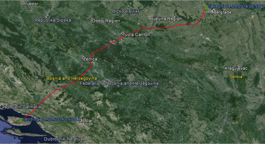
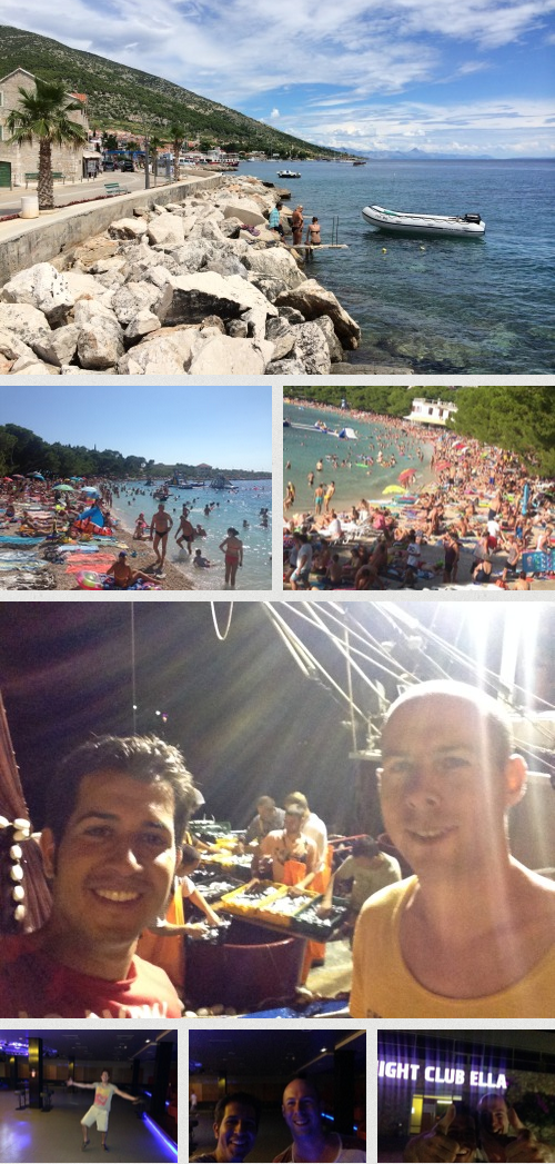
After two days of city life, I started thinking about flying again on Sunday afternoon before our departure, while Arvind was emptying some bottles of wine with an old colleague of his. At this point, we dropped Sarajevo and Montenegro (which were both optional up to this point) from the plan. Sarajevo was unrealistic to fly into. The city is located in a valley surrounded by substantial mountains and was at this point (as it apparently is quite often) completely covered by a layer of cloud within the valley – impossible to get into under visual flight rules! Besides, after a long city weekend, we were actually looking forward to a change in scenery type. Montenegro would have been possible, but we figured the further south we travel, the further we’ll have to travel back up north later (a simple truth!). It was then Arvind’s responsibility to tell me where in Croatia we wanted to go and I’d find the closest airport. I think he basically googled what place in Croatia has the best party crowd and he came up with two options, Makarska and Navalja. We settled for Makarska and a landing on the island of Brac, just off the coast.
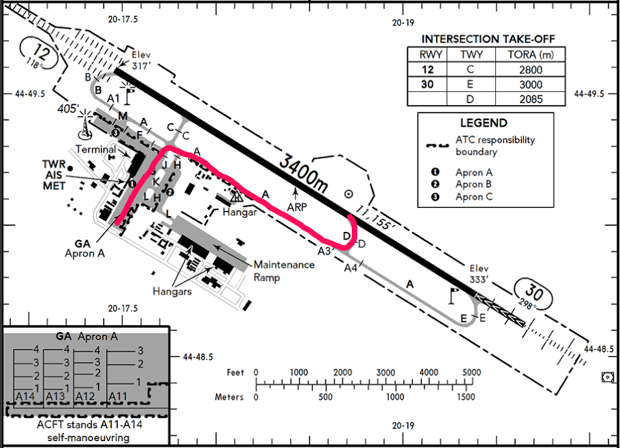
After some thunderstorms and precipitation on Sunday night before our departure, we woke up to cloudy (at 2000 ft) but dry weather. The departure out of Belgrade was as easy and straightforward as the arrival. I needed to fill in some forms at the General Aviation Terminal. We spent some time there checking the weather for our route to Croatia, filing the mandatory flight plan, and finishing our breakfast (which the hotel had packed in bags for us). We were then driven to the airplane by the handling agent, who I also settled the final bill with, while Arvind began to load our luggage into the Cessna again. After running the preflight checks (it’s handy to have a regular passenger. Arvind by now knew more or less when to hand me what, e.g. a checklist) and listening to the ATIS, we requested taxi clearance for runway 30. We were cleared to taxi to holding point D via taxiways G, A from our parking position at Apron A. The airport was pretty busy (not surprising on a Monday morning) and before maneuvering on A, we were asked to give way to a departing Air Serbia flight from Apron B.
At the holding point, after performing the standard engine run-up to check if the engine is performing as expected, we advised ATC that we were ready to receive our departure clearance. This turned into a minor problem, as we were cleared via a reporting point that I couldn’t find (in SkyDemon). This was SOMUN in Bosnia, deviating from our filed border crossing point. I checked this later on the ground and the reporting point is actually there – I’m not sure what went wrong in the cockpit. Eventually, we found the point in the panel-mounted Garmin GNS 430 GPS. Departure was smooth and gave some good views of the Belgrade area (although a departure in the reverse direction on runway 12 would have been favorable from a sight-seeing point of view). My first objective was to get above the cloud layer, while there were still holes. Soon after departure, I requested Beograd Radar to climb to 9500 ft. The answer was something like “Uuh, one moment, sir. I’ll check and get back to you” – I found this a usual pattern that we observed a couple of times on this trip. Most requests were immediately approved, but whenever we requested “higher” altitudes as a VFR flight, there was some hesitation, indicating that this is not a normal procedure. I wonder, though, how they expected us to cross Bosnia if not at a high altitude. The country is pretty much 90% mountains and some are quite massive.
At the border crossing (or rather, at SOMUN point), we were handed over from Beograd Radar to Batanija Flight Information briefly. We had trouble communicating with that station and thankfully, were handed over to Sarajevo Radar soon enough. Here, we were met with the same “flexibility” in terms of heading and altitude changes to avoid various fields of clouds that we had experienced in Serbia before. We were flying on top of a very solid cloud layer in the valleys, which reemphasized that an approach into Sarajevo through that sauce was just not going to happen for us.
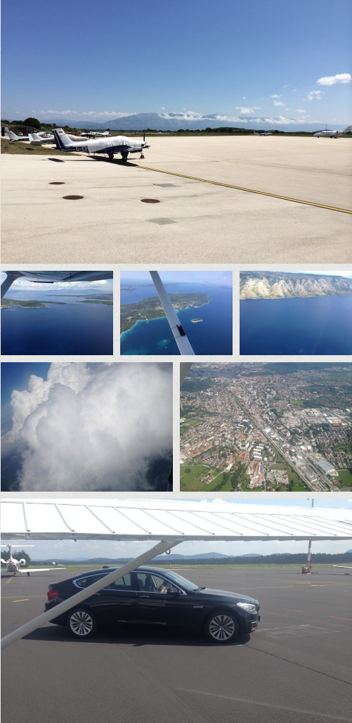
5 minutes before reaching the border to Croatia, we said goodbye to Bosnian ATC and contacted Split Approach. That frequency was just so much more busy – mostly with GermanWings flights in- and outbound of Split airport, obviously. Since our destination was Brac, which is a bit south of Split, we didn’t worry about that traffic too much. We were still quite high at this point at 10.500 ft. This meant two things: First, the view once breaking out of the mountains was spectacular. We had ridges to the right and to the left and obviously behind us, the Adriatic coast ahead of us and we could even see our destination island and the airfield from as far as 20 miles out. Second, we needed to plan our descent. When flying at home, that’s usually not much of an issue: My home field Essen-Mülheim is at 400 ft and I usually don’t fly much higher than 2000 ft due to restricted airspace above. But at 10.500 feet, with a destination airfield elevation of 1.700 ft above mean sea level, some arithmetics are in order. Descending from 10.500 to 1.700 is an approximate altitude difference of 9000 ft. With a target descend rate of 500ft/min (as can be verified by checking the Vertical Speed Indicator/VSI), we would need about 9000/500 = 18 minutes for this. At 90 knots indicated airspeed, this implies you should start your descent when 27 miles from your destination (90 knots = 90 nautical miles per hour, i.e. 1.5 miles per minute, 18 minutes x 1.5 miles/minute = 27 miles). In the practical test for the license, examiners like to call out questions like this to make you calculate some stuff while still focusing on actually flying, too.
So it was time to ask for a clearance to descend – which was granted to us in steps. Thanks to our flight route, we were already established on a very long final to Brac runway 22. Before entering Brac CTR, Split Approach advised us that Brac tower was unmanned at the time and we were free to land at our own discretion. There was no other traffic in the air, but I still made blind position calls on Brac tower frequency to let anyone listening know we’re coming. Indeed, on short final, another aircraft appeared on the radio that was taxiing out to the runway from the apron. I have to admit that I entirely forgot to consider wind direction and runway in use in this case, not being TOLD to use a specific runway. I simply staid on the final already established – less than ideal! It was also pretty bumpy on short final (the airfield is at the top of the island and quite exposed to some gusting winds, it seems) and the landing certainly wasn’t the best performance on this trip. We bounced a little before touching down permanently.
Brac airport is not exactly huge. We smiled a little when after backtracking on the runway (there is no taxiway parallel to the runway), we were greeted again by a follow-me car (an old Lada or such). It’s a nice gesture, but we have reason to believe that we would have found the way to the fuel station on our own, too. Refueling service was quick and efficient and the guys helped us push the Cessna to a parking position with chains for a proper tie-down. The airport has a proper terminal, but everything is miniature size to the point of being outright cute. A mini terminal with a mini baggage claim belt (a circle) and a mini customs berth. There was actually a customs guy asking with a mischievous, if slightly bored grin: “Do you have anything to declare?” and we said “Naw…” and he turned away and we passed with our perceived 18 bags.
Destination: Makarska and the Island of Brac, Croatia
We took a taxi to the village of Sumartin, where the ferry to Makarska on the mainland, our destination for the day, would depart. We had some time to kill and no accomodation booked for Makarska (one of the busier tourist destinations in Croatia and we were right in the main season) so we figured it was about time to look into that. Equipped with an iPad and roaming and an open booking.com window, we walked into the tourist information office to see if we could find some advice. We met a friendly and helpful lady who was trying VERY hard to convince us not to go to over-crowded, dirty, cheap Makarska. But we just had to see for ourselves, so all her efforts were in vain. We ended up booking an apartment while on the ferry. When we reached Makarska, we were about a good hour too early for check-in, but we decided to try our luck anyway. The apartment was one of three in a private house. When we rang the doorbell, we were clearly not expected. Turns out, there had been a double booking. The owner was expecting Eduardo from Czech Republic with five friends to arrive for the apartment. Funnily enough, the owner was annoyed by the situation and blamed booking.com (I have no idea WHAT exactly went wrong here) and his opinion was: “You arrived first so you get the apartment.” Glad we went there an hour before check-in! I still feel a little bit sorry for Eduardo and his friends, as the city seemed about fully booked. We loved the apartment, though – plenty of space for us.
The plan for the rest of the afternoon was beach time. Okay, so I’ve never seen anything like that except on photos from China. The beach was absolutely and fully packed with people. There was no space to place your feet while walking across it other than on other peoples’ towels or extremities. The sea was equally packed. To process the shock, we had the shabbiest food at a “beach side restaurant” and then we found ourselves some spot (!) to put our towels. We spent 5 minutes in the water/dissolved sun lotion, 10 minutes on the towel, took several photos and left. I wonder what sort of people come to such a place and actually love it and come back the next year.
While some more solitude at day time would have been appropriate, the city was just full enough to be absolutely alive at night. We figured the place is a sort of “Ballermann” for Bosnian tourists. Here, we found the local equivalent of what we knew as “Balkan Pop” from home: Turbo Folk. Great fun, as long as you keep injecting that Whisky-Coke mixture directly through your intake valves…
After two days and nights, we had seen enough and decided to spend the last full day in Croatia in Bol back on the island Brac. This would allow us to take-off to our next destination the next day as we pleased, not being limited by ferry schedules. It also allowed us to spend an afternoon on a beach that deserves that name.
Flying Leg: Brac (LDSB) – Ljubljana (LJLJ)
The flight from Croatia to Slovenia was the only flight that we did not plan for an early morning departure. We were less worried about up and down drafts as the route contained less mountainous terrain and we were less stressed to go to bed all too early the night before – so we could have a good dinner and enjoy the city of Bol. I filed our flight plan from the iPad with SkyDemon and we took a taxi to the airfield after sleeping in for a bit. We were sent to the administrative office to pay our fees and also to receive a call from Split ATC – they had a question about my flight plan filing! I had used some of the VRPs along the Adria VFR routes and in Slovenia and some of the latter ones were not known to the controller who reviewed my flight plan. We resolved everything on the phone and I appreciated the experience that the flight plan was actually received and reviewed by a real human.
When we were taxiing for our departure, I assumed the airfield was still uncontrolled as it had been the day before. My mistake – the lady from the administrative office apparently had a second job as a controller and the CTR was active. So we had to get a departure clearance from her! She was nice though to grant us, even though runway 04 was active, to turn onto downwind and depart via the southern coast of the island to get a very good view of Bol and the beach we spent the previous day on.
More often than not, aircraft climb to their desired or assigned altitude after take-off. In this case, we were assigned an altitude that was lower than our departure airfield. While we crossed Split TMA, our altitude was 1500 ft. The airfield elevation at Brac is 1776 ft. Later on, we were approved to climb to 2500 ft, which is more comfortable from a safety point of view but you cannot make out as much detail on the ground anymore. Flying along the Adria like this is fantastic. The islands, their small villages and ports and the coast are very pretty. We were not the only people who saw it that way – the coastal waters were literally packed with sailing boats.
At around Senj on our journey to the North, we ran into a bit of a situation. We lost radio contact for a few minutes and experienced some very noticeable up and downdrafts, shaking us around and bringing us closer and again further away from the water surface. At the same time, we needed to initiate our climb to a higher altitude in preparation for the mountainous terrain ahead once we left the coast. The climb performance of our loaded airplane, after all, was not exactly like a rocket. I remembered the rule “Aviate – Navigate – Communicate” and initiated a climb and kept trying to contact Riejka for a climb clearance. This eventually worked and we were cleared to climb to 9500 ft.
After crossing the high terrain in Northern Croatia/Southern Slovenia, again mostly on top of cloud, we let ourselves fall back to a lower altitude, circling through some holes in the cloud layer, and we proceeded towards Ljubljana under Slovenian ATC control. The approach into LJLJ was smooth except a 360 turn that we needed to perform in order to let some faster IFR traffic land before us (I think it was an Adria Airways flight). The approach again gave us good views of the city and later that day, when we considered hiking up to the castle, we almost said “Why? We’ve seen it all and much better…”. We hiked up anyway.
Upon parking on the General Aviation apron, we were welcomed by a lady who came from the GAT with a black BMW 530. For a brief moment, I had reminiscences of a First Class Lufthansa flight (where you get picked up at the terminal and driven to the aircraft in a Porsche Cayenne), but they lasted only ever so brief until I realized she wasn’t going to take us in her fancy car. She let us know we could walk over to the terminal and see her there and drove off. I have a feeling, had we been more important looking in more important looking clothes and possibly with a more important looking airplane, we may have received a different treatment. Seriously, she was nice and helpful enough, and helped us out with finding accommodation, which we hadn’t booked beforehand. Unfortunately, our first choice, an old town boutique hotel, changed from available to fully booked while we were considering. We ended up choosing a backpacker hostel. Ironically, this meant we’d spend only the last night of the entire trip on a budget, while we had planned to do that for almost all nights.
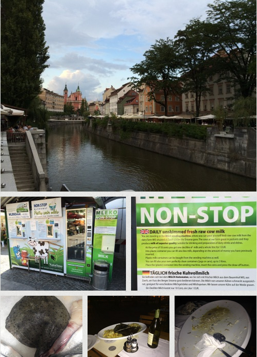
Destination: Ljubljana, Slovenia
Another great place to visit! While still in Croatia, Arvind had been going on about if it’s possible to go straight from the coast back home without another stop – but I believe he was also pleased we made that stop. Despite our late departure, we still had the better half of the afternoon to explore Ljubljana. We started out at the local market, buying some fresh fruits and marveling at the Melk-O-Mat, which is like an ATM but for milk. We hiked up the stairs to the castle and had our ALB there, the after-landing-beer. We also sampled some local sausage with more beer and started meeting people, like a political science academic from Northern Germany who we ran into again later in the city and had another beer with. By the end of this expedition and the afternoon, I was adequately tipsy and could have just gone to bed and slept all night – but how would that do justice to such a beautiful city? So we went to the hostel to rest for a bit and freshen up and went out again – this time for proper dinner. We had fresh plaice at an excellent restaurant/fish store near the market with an equally excellent waiter – who told us his story why he doesn’t eat fish while professionally filleting ours at the table. We then proceeded down the main street of the old town again, coming to the Tromostovje, the Triple Bridge (a place you can easily make out on a map of Ljubljana if you care for it). We noted with delight that there was life music and we stayed. Arvind soon became annoyed that no one was dancing and was beginning to look around for people to dance with. We ended up dancing and talking with three very charming social science students and helped them get rid of some guy who had followed them for a while and who they found annoying (anyway, that’s our point of view. Could have been the other way around, huh?). As it became later and most other people had left, the band was still playing and had moved on from pop classics to local folklore and Arvind managed to get on stage and co-sing some German songs, too – most notably “Verdammt ich lieb Dich!” and “1, 2, Polizei”.
Flying Leg: Ljubljana (LJLJ) – Frankfurt-Egelsbach (EDFE)
For our departure out of Ljubljana to fly home, I originally planned the same route as our southbound Alp crossing. Due to very good weather, though, we changed that on the day of our departure to a more direct route via Villach, Millstätter See, the Tauernautobahn, St. Johann im Pongau and Zell am See. We flew at about the same altitude as a week ago, but with higher terrain to our sides, following the valleys still at a save altitude, and a broken cloud layer on top at around 10.000-11.000ft. We didn’t strictly have to (the conditions would have allowed for a more or less straight crossing, probably) but we navigated according to the published VFR routes and I experienced first-hand how difficult it can be to find the right valley, even when using a GPS moving map. This time, it really felt like mountain flying with spectacular views – though I’d still not choose to fly low in the valleys without proper training. The route saved us around 30 minute of flying time as we didn’t have to include a detour to the East.
Back in Germany, we needed to descend in order to fly below Munich Class C airspace, as we wouldn’t get a clearance to pass through C on our routing (this was the approach sector for EDDM Munich Airport). Flying low level over the city of Munich was very bumpy and unpleasant. The rest of the flight past Munich was uneventful, a bit boring and took too long. After being spoiled by the panorama of the Alps, I couldn’t find any joy in flying over flat Germany that day anymore. Consequentially, maybe, I screwed up the first attempt at landing in Frankfurt Egelsbach (where I’d be dropping off Arvind), had to go around and land okay the second time.
Flying Leg: Frankfurt-Egelsbach (EDFE) – Paderborn/Lippstadt (EDLP)
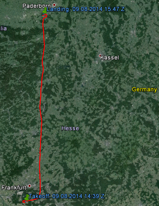
The next day, after spending the night with a friend in Frankfurt and after a good breakfast, I headed back to Egelsbach. Officially, the trip had ended the day before so we had had no weather based delays or diversions – but on this Saturday morning, I couldn’t get out of Egelsbach right away. The wind was pretty gusting and made a departure dangerous. Additionally, the GAFOR for the Sauerland area (which I’d be crossing on the way back to Paderborn) was marginal. There were low clouds laying over the Sauerland hills but the outlook for the early afternoon indicated improvement. I was forced to spend some time at the airfield, which I used to start sorting the trip paperwork. About two hours later, conditions had improved indeed and I flew back to Paderborn alone, leaving the skyline of Frankfurt and the city of Marburg behind me. The landing in Paderborn on runway 24 was one of the few crosswind landings on this trip but went okay. Unfortunately, I taxied too slow on the large runway and conceded a telling-off by the tower: “D-ECVK, if you continue like this, the 737 behind you is going to overtake you…”. I expedited to vacate the runway ASAP. ;-)
The end of the day stretched my patience when after washing and hangaring the Cessna, I missed the last straight train to Düsseldorf on a Saturday evening. I wasted 40 EUR on a taxi to the central station of Paderborn to catch the last remotely convenient train and missed that one, too, by seconds. Stuck at the station with my several bags, I ate fast food and waited for some other connection. That train came in with a delay, causing me to again miss the connecting train in Hamm, getting back home around midnight about 4 hours later than expected and missing the better part of a birthday party I was invited to.
All in all, an unforgettable trip though and hopefully a role model for many more to come!
KML Track Logs
Paderborn – Wels
Wels – Belgrade
Belgrade – Brac
Brac – Ljubljana
Ljubljana – Frankfurt
Frankfurt – Paderborn