
Objective
This article describes an IFR (airways) flight from Shoreham (EGKA) to Prague (LKPR). The intention is to show the entire IFR flight planning process, for a nontrivial flight in the European airways system, in a non-deiced aircraft with oxygen and a 20,000ft ceiling (a Socata TB20). As is usually the case with a correctly planned IFR flight, the flight itself was straightforward.
Route planning
As with all IFR flights outside the UK, an ICAO flight plan must be filed and this is done via the Eurocontrol system. As described in detail here the simplest way is find a valid route is to initially try the free and unofficial ASA route planning website. Entering EGKA LKPR, altitude between FL080 and FL160, Low Level airways, and selecting the RAD, CDR, Use Daily CRAM checkboxes generated the route
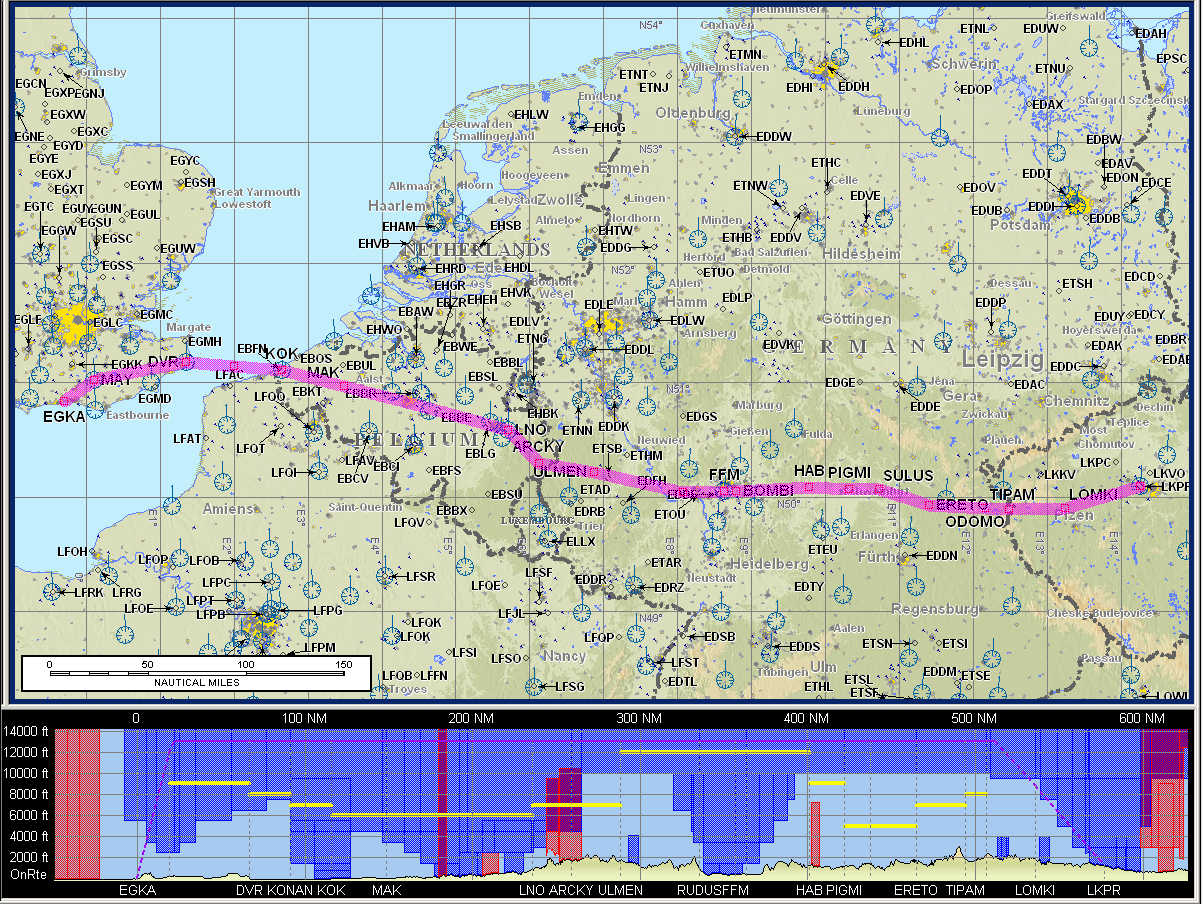
MAY R8 DVR L9 KONAN L607 RUDUS L984 SULUS Z650 TIPAM Z35 LOMKI
which was pasted into the Eurocontrol validation website and generated the much sought after NO ERRORS message. Often, the initially generated route does not validate and one has to go to the bottom of the ASA page and check the various restriction violations which it puts up, and re-route. It is an iteriative process which usually works… eventually. Another way to do this job is to wade through the various countries’ preferred route publications… Edit 11/2009: the above mentioned ASA routing site is still there but FlightPlanPro offers a much better way of developing IFR routes.
Unfortunately one cannot load an airways route directly into a GPS – unless it is one of the new models that support named airway routes e.g. a Garmin 480. Any older GPS has to be loaded with the waypoints that make up the route. One can get the waypoints by picking them off the route on the paper IFR chart, or one can do it by generating a “plog” (a list of waypoints with headings, etc) with the Jeppesen FliteMap IFR or FliteStar IFR flight planning program, using its Plain Text route specification function (in the Routepack Wizard function). (Jeppview 3 has the same plain text input in its routepack wizard but it doesn’t call it that; the plain text input is the default mode). This also generates a picture of the route like those shown in this article, and you can print off various chart sections (which, assuming you have a current database, avoids the need to spread the paper charts all over the cockpit), the flight plan to be filed, etc. My GPS is a KLN94 which, like all the old-generation units, does not accept direct airways-name entry; moreover has a 20-waypoint limit per flight plan which can be fun on some routes… Obviously one needs to load all waypoints at which an airway changes direction; it’s debatable whether one needs to load in those where it doesn’t but doing so can be helpful if ATC give you a DCT to one of them.
The ICAO flight plan can now be filed using any means available to the pilot for filing flight plans. I use the Vienna ATC facility called Homebriefing which costs a mere Euro 36.00 per year and which (unlike all other known website flight plan filing facilities) will accept flight plans for flights wholly outside its own country. This is a fantastic service, allowing you to online edit the flight plan right up to the departure, change its time, etc. The IFR flight plan was filed without the usual “IFPS ROUTE AMENDMENT ACCEPTED” option and was indeed accepted without modification.
Unlike with VFR flight plans, there is no need to specify EETs to national boundaries. The whole flight is seamless, with handovers from one control sector to the next. Individual countries within Europe become unimportant. Controlled airspace considerations are also irrelevant; most or all of the route will be in controlled airspace. Restricted/prohibited areas also don’t matter – ATC will not knowingly direct you into one of those.
If a level change is requested due to weather ATC will normally allow the level change, especially if requested due to icing. However, it is advisable to check that the route will pass the CFMU check at different flight levels, from the lowest (which lies below the 0C level and which one might therefore fly if encountering icing; FL100 in the above route) to the highest (which provides VMC on top, FL150 above).
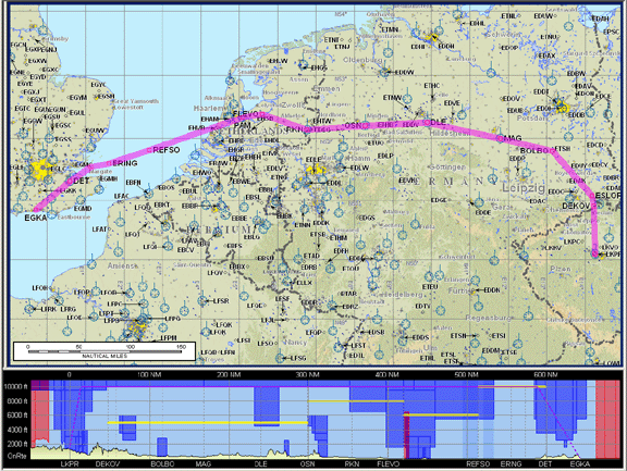
As I was going to fly back the following day, I also wanted to work out the return route and file a flight plan for it. This route proved to be a lot harder and I was unable to get anything out of the ASA website that was acceptable to CFMU; checking off the various route violations in the ASA site only generated yet more route violations. I have done this before and Prague must be one of the hardest routes to work out. So I capitulated and emailed CFMU who very helpfully returned these two routes
DEKOV Y621 ESLOR M748 BOLBO L986 DLE L179 OSN G9 RKN B5 FLEVO R105 PAM L980 REFSO Y76 DET
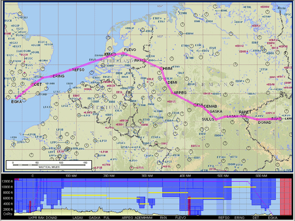
RAK L984 DONAD T170 RAPET Z23 SULUS L604 FUL Z52 ARPEG Z850 HMM B5 FLEVO R105 PAM L980 REFSO Y76 DET
Initially they sent me the first one but when I plotted it in FliteMap it turned out to be rather long. I queried this and got the 2nd one which is a bit better, but not much.
The 2nd route arrived only when I was already in Prague and for some reason I was unable to plot it in FliteMap; the program complained about T170 having an MEA above the aircraft ceiling (20,000ft) and wouldn’t plot it at all, so I plotted it in Navbox by manually dragging the track to every relevant waypoint which made up the airways route! Not having a printer I then copied out the plog from Navbox by hand, all 19 waypoints, so it could be entered into the KLN94 GPS. On my home PC, the route generates similar errors in FliteMap but in that case the route does get plotted… very weird! This is the latest version of FliteMap too, with the current airways database.
Weather Planning
IFR weather planning differs from VFR. An instrument-capable pilot in a well equipped aircraft can generally fly “VFR” in atrocious weather provided he remains below the cloudbase, or provided he can fly VMC on top with a virtual certainty of having a clear sky at the destination. With IFR one has to be more careful because the assigned level could keep you in IMC for extended periods – this brings airframe icing risks, or could take you into embedded stuff like CBs. Contrary to what most VFR pilots think IFR is about, the objective is to fly in VMC - above or below the clouds. In Northern Europe, any extended stay in cloud at typical airway levels is likely to result in various degrees of icing, and flying in cloud is no fun anyway. While ATC will always (sometimes not straight away) allow you to escape dangerous weather or airframe icing, the aircraft may not have the performance.
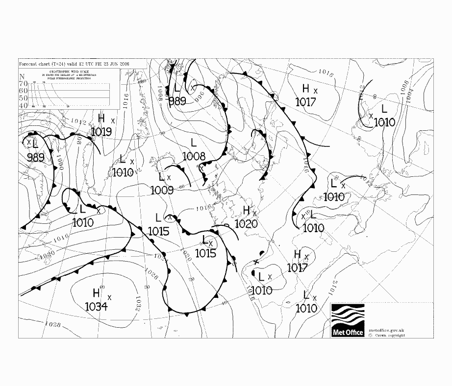
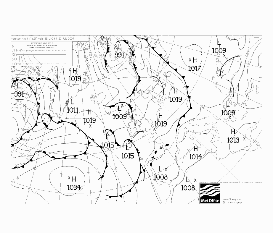
The first thing I look at is the MSLP chart. This indicates the most obvious nasties like cold fronts, warm fronts, or troughs. However, this provides a limited amount of information and one must dig deeper. This and this are the MSLP charts from the return route; I have lost those from the outbound route but one can see the equivalent relevant information onthe SigWx charts referenced below. I would generally not fly through a cold front if I was likely to be sitting in IMC, so scattered CBs are OK provided there is no organised thick cloud layer which is too thick to climb on top of. A cold front, in IMC, at the departure/destination is a real problem because one has to climb/descend through it.
So, the next thing is to establish the likely vertical extent (bases and tops) of the cloud cover. This is to ensure, as far as possible, that the flight will be in VMC, or at least below or above the layer with icing potential (roughly 0C to -15C). For VFR flight, the obvious way to get the bases is a list of TAFs for airports along the route, but this easy option will be available at most 24 hours ahead. Unfortunately TAFs provide no clue to cloud tops, or to the existence of additional layers above the reported base which itself could be something rather benign. A base of FEW030 looks nice for a VFR flight below 3000ft (above the aerodrome level!) provided this is above the MSA, but is of no use for an airways flight at FL100 if there is a solid layer from 6000ft to 20000ft and the freezing (0C) level is at 8000ft! Cloud bases above 5000ft AAL are also not reported in TAFs or METARs.
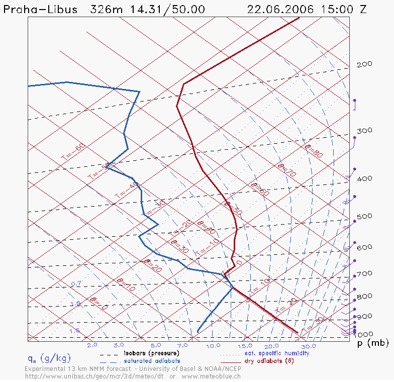
To get an idea of the vertical profile of the atmosphere you need to look at a forecast tephigram like this. This one, for the outbound route, shows a likely cloud layer between 750mb and 650mb i.e. (very roughly) 9000 to 11000ft. Importantly, the 0C level is around 700mb (10000ft) which is OK relative to the available airway levels (basically anything above FL080, or lower if you really need it and there are no terrain issues) and the aircraft ceiling which is about 18000ft (500mb).
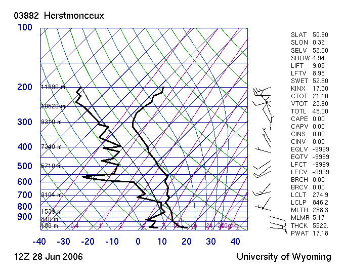
The weather balloons go up at 0000Z and 1200Z and if the flight is departing say an hour after that, one can get the real atmospheric profiles from here (select Europe, GIF/Skew-T) and you get something like this (this example does not relate to the flight described here) which is called a Skew-T and is a variant of the tephigram with a slightly more obvious x axis. This is real data and accurate for that time and place. Unfortunately, on most flights the timing doesn’t work out well enough to use this infrequently updated data.
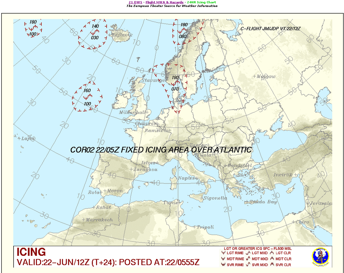
Additional data comes from the standard SigWx form here and here. These show a cold front moving slowly in the SE direction, and the flight was therefore done in the afternoon, so as to arrive behind this front. The SigWx is a very good form and I can see why jet pilots use it; however the TB20 operating ceiling is not that high. The standard Form 415 (a version of the UK Form 215) is is limited use at airway levels. This USAF website contains icing potential data (under Flight Hazards); I am not sure just how accurate this is when it comes to light icing which one can pick up almost anywhere if flying in freezing IMC for long enough.
An article on cloud tops is here.
I am not a weather expert and do my best to interpret the data I can get. If in doubt I phone up a professional forecaster on a premium-rate number: Weatherlive (UK) 09065-150046, £1.50/minute.
Other Stuff
One needs to get Notams. ICAO requires a pilot to use the briefing facility provided by the country of departure but for IFR between international airports this is plain silly because an aircraft with sufficient range could fly any route whatever. So I use the UK AIS website; the Narrow Route Briefing. One should enter the flight planned route; that should flag up relevant en-route factors like an out of service VOR. The value of the en route data is slightly debatable since (under ATS control) one probably won’t fly that route anyway. However, the really important stuff is at the ends; for example on a recent flight (Berlin Tempelhof) I found the ILS and VOR out of service, leaving just the NDB approaches.
I never use airport weather briefing services. I carry a PDA and a laptop with a tri-band GPRS card (pay as you go) and can get conventional internet access on those. GPRS works reliably throughout Europe and the USA. The laptop can also send faxes which is very useful for “prior notice” airports.
In the UK, one has to fax the GAR (General Aviation Report) form to one or more of Police, Immigration, Customs. This is true for all flights, VFR or IFR. In this case (EGKA) I needed to notify Immigration only of the return flight. Prague has 24hr Customs, whose notice is satisfied by the filing of the ICAO flight plan.
I use oxygen anywhere at or above FL100, using a portable Aerox kit purchased from the USA. This is essential for flight at European airway levels, due to the difficulty of getting reliable cloud top forecasts – if you don’t want to accept lengthy detours. The oxygen flow rate increases with altitude and this becomes a flight planning issue: one will choose a lower level if going away for a long time. On this trip, this wasn’t relevant since there was no way for me (flying alone) to use up the whole bottle – even if I did the whole trip at the aircraft ceiling of 20,000ft.
Flight EGKA-LKPR
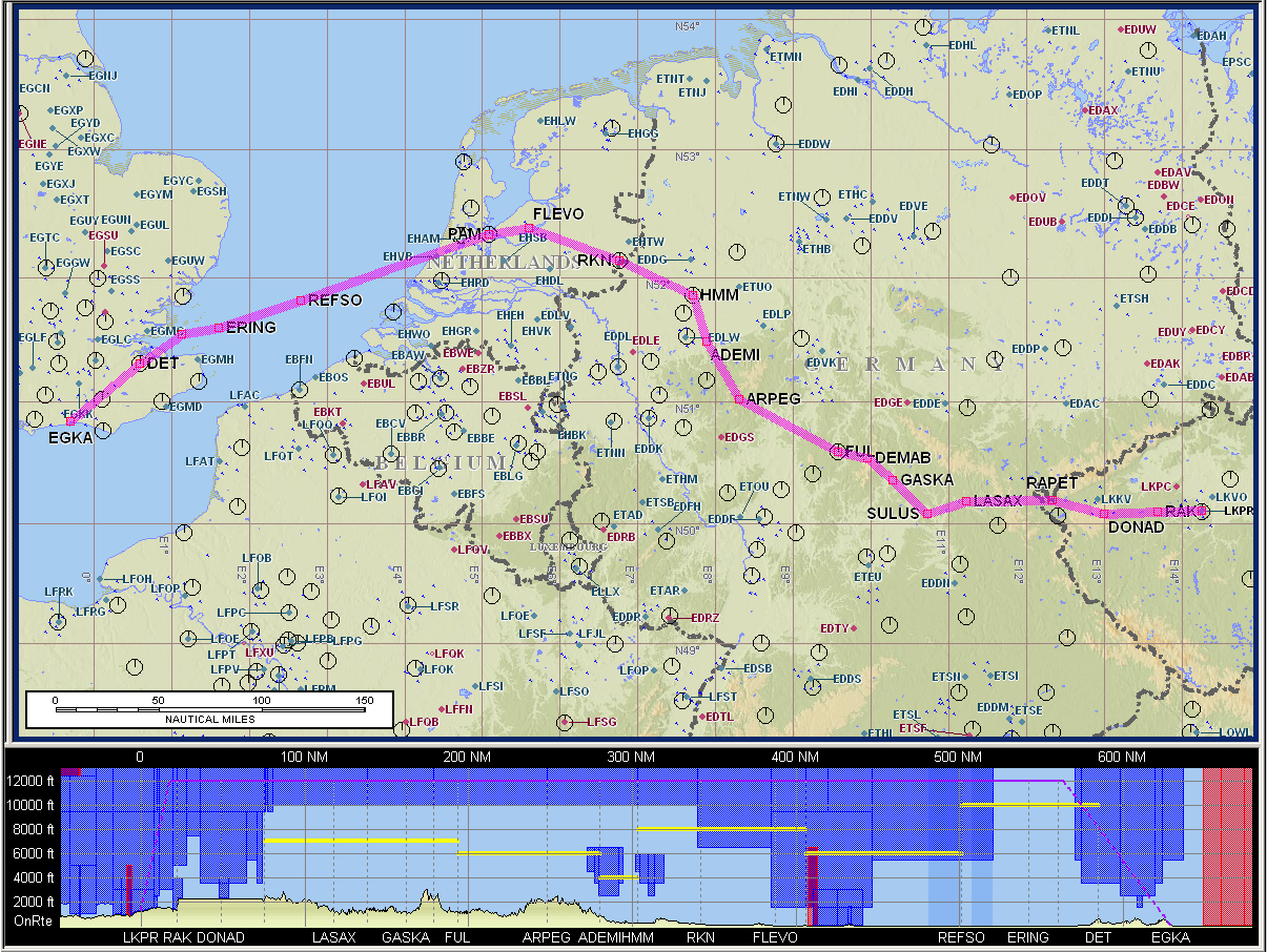
As described above, the filed route was MAY R8 DVR L9 KONAN L607 RUDUS L984 SULUS Z650 TIPAM Z35 LOMKI
Warning: This article includes route illustrations (like the one above) produced by Jeppesen Flitestar/Flitemap, which include a vertical (terrain) profile at the bottom. It has recently (Feb 2007) come to light that the Jepp terrain elevation data is grossly inaccurate and can be several thousand feet out. Furthermore, the error is usually in the unsafe direction. This feature of the software is therefore useless for any flight planning or terrain avoidance purpose, even in an emergency.
Upon sight of a flight plan which is obviously an airways flight, Shoreham ATC will phone up the first IFR sector (London Control) and obtain a provisional IFR departure clearance, comprising of an initial route (always remaining outside controlled airspace, OCAS), a transponder code, and the first IFR sector frequency to contact. You then collect this clearance before lining upon the runway, in the normal “Nxxxxx ready to copy departure clearance” manner.
I had flight planned for a 1200Z departure but a few hours beforehand received an email and a SMS message from Homebriefing advising me that a slot time had been allocated for 1210Z, due to traffic density. Not a big deal at all.
So I got airborne with a clearance of DCT MAY, climb 2400ft, remain OCAS, squawk 0516, contact London Control 133.17.
London gave me a DCT SFD FL080, HDG=105 after SFD so the filed flight plan didn’t last longer than the first radio call!
After that I got a long string of instructions comprising of vectors or DCTs or “own navigation to XXX”. Occassionally I was given a DCT waypoint which happened to be on my filed route. As usual on airways flights, the entire flight was a straightforward RNAV point to point navigation exercise based around airways intersections and thus very difficult without an IFR GPS. Many of the waypoints given are too far away for the old-style RNAV product (e.g. a KNS-80) to work; for example I was given DCT ODOMO from 115nm away and a KNS-80 would have not had VOR/DME reception from that distance. In practice one also tunes in any VOR/DME one can find on the route but a lot of the time there isn’t anything in range that lies on the filed route.
Overall, the filed route was flown reasonably faithfully:
The above track was captured in FliteDeck (part of JeppView 3) running on an LS800 tablet computer.
The flight was filed for FL130 but before reaching FL110 I asked for a stop climb at FL110. This conserved oxygen and probably gave me a slightly better speed, although not knowing the wind profile I may have been better off at FL130. However, 60nm before Frankfurt airspace I was asked to climb FL130 or accept a detour, since FL130 was the lowest acceptable over Frankfurt. I said “it will be a slow climb, about 300fpm” and he replied “fine, you haff 60 miles to go”. So I climbed to FL130. Actually the TB20 can do better than 300fpm at 11,000ft but obviously the speed drops off and it’s always good to look after engine management (cooling) if there is no hurry.
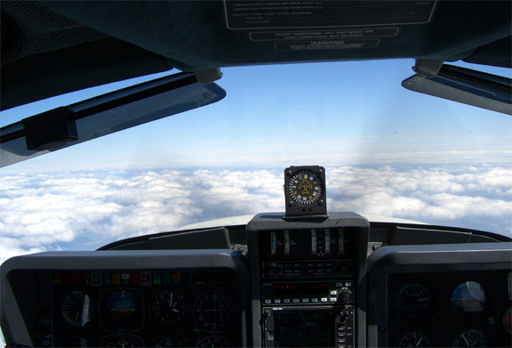
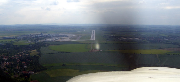
Almost the entire flight was VMC on top as shown below, mostly above a thin broken layer. This is what IFR flight is all about: mission capability limited only by aircraft performance, and low enroute workload. It’s not for everybody, and I much prefer VFR for the view when the weather is OK.
However, about 50nm before Prague I encountered gradually rising tops, entered IMC and eventually started to collect some rime ice, perhaps 1mm every few minutes. The stormscope was showing some returns too, to the right of my track:
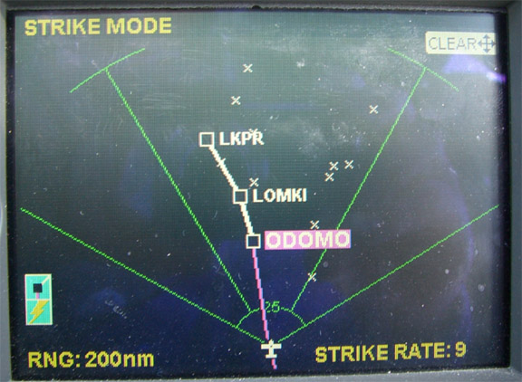
I had been watching this stuff from much further back when still in VMC; looking out for the back of that cold front which I was catching up with (the WX500 displays returns up to a 200nm radius) and could see some TCUs in the distance. I certainly was not going to fly into those, but both the stormscope returns and the TCUs appeared to be to the right of my track. I find the stormscope good for direction – usually spot on when flying in VMC with groups of CBs in the distance – and less accurate for the distance which can be out by a factor of two. If I had not seen the stuff visually a few minutes before I would have asked for a 20 degrees left “due to weather” just in case.
The rime ice was pretty harmless and I have a TKS de-iced propeller which I use in any freezing IMC (switch it on a minute before entry) but it’s always best to make decisions soon rather than late so I asked for a descent to FL090 “due to icing”. Prague Radar gave me a descent to FL100 which I initially accepted and which turned out to be fine since the cloudbase was about FL105 and it got me out of the cloud. At about 30nm to run I received a descent to FL080, then FL060, then 4000ft, then (given good VMC) I was offered a visual approach or ILS and being lazy I chose the ILS.
The Prague ATIS gave the LOMKI 1S STAR which was the correct one for RWY 24 and for my route. Prague has a huge array of STARs and SIDs, and 3 or 4 ILS runways, so I had asked one of the preceeding (German) sectors to phone Prague and get me the current runway so I could get the paperwork in order.
There was a very useful 40-50kt of tailwind for most of the flight and on the descent to 4000ft I saw the highest ground speed I ever saw on the TB20, 211kt:
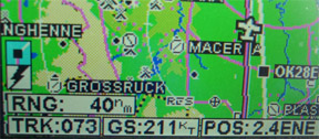
This corresponded to about 165kt IAS.
ATC was obviously happy with this but as my speed of course dropped off pretty quick upon levelling off, they asked me to speed up because of other traffic. So I intercepted the localiser at the gear limiting speed (130kt) and slowed down on the glideslope.
The unchallenging landing (the runway wasn’t exactly short) was followed by a very long taxi (behind a FOLLOW ME vehicle) to the “old terminal” which is reserved for private aircraft; mostly small jets. Prague does get a reasonable number of piston GA aircraft too; their landing+handling+parking fee is about £40 which is very reasonable for an airport of that size.
The entire flight, including the ILS, was flown on autopilot. Airborne time was 3:35.
I asked for Avgas while still taxiing; this trick helps at a lot of places but here the Ground controller was not able to help. However, the airport handling bus turned up within minutes and I told him I needed fuel so he organised it; all done very quickly. The accept the Air BP fuel card, or credit cards. Tax free Avgas is available to “commercial” customers but only on production of an AOC; this appears very common around Europe.
Everything is very easy at the Prague airport. A police officer looks at the passport and you go straight out to a taxi; 8 miles and 350 crowns (about £8) to the city centre.
Prague
Prague is a great old Central European city. I won’t write what you can find in a travel brochure but here are a few pictures. The first two are views from the famous Charles Bridge:
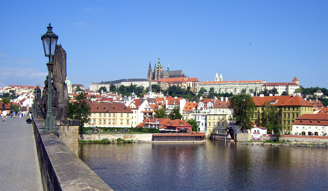
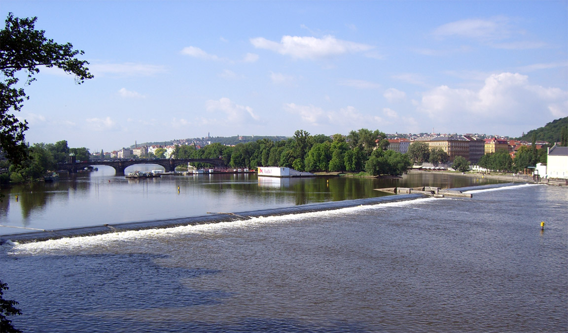
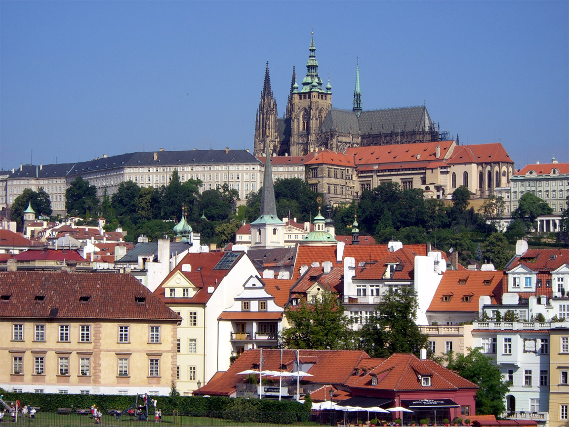

The main portion of the city is very different today from the Dark Ages of communism. I was born there in 1957 and remember it well. My Czech got some good practice but needed a lot more. There are many tourists now and consequently the prices are up to European levels. It’s a super city, with everybody being very friendly and helpful.
However, the popular part of Prague is a small place and a 30 minute walk in most directions out of the tourist area will take you into parts which have not seen a coat of paint in decades, you can get a meal for £1, and English won’t get you very far…
Flight LKPR-EGKA
Getting out through the GA terminal at Prague airport is easy; you just pay the fees, walk through a security check and get onto the bus.
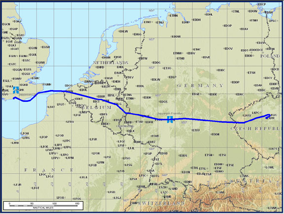
The filed route was RAK L984 DONAD T170 RAPET Z23 SULUS L604 FUL Z52 ARPEG Z850 HMM B5 FLEVO R105 PAM L980 REFSO Y76 DET
Prague has a dedicated Delivery frequency where you collect your departure clearance while still on the ground. Then start the engine and call up Ground who give taxi instructions to the runway threshold where you do power checks and then they change you over to Tower. The SIDs request an automatic change to Radar immediately when airborne but in this case they told me to remain on the Tower frequency.
Current runway (on ATIS) was still 24 and this was used by the heavy traffic, but they offered me 31 since the wind was 310. The holding point for 31 was also usefully very close to the GA parking area.
However the offer of runway 31 caught me by suprise since I had not studied the SIDs for 31, so I said I prefer 24 unless I get a radar departure. (In reality, all arrivals and departures at large airports tend to be radar vectored but one still needs to be able to fly the SID or STAR if required, at short notice).
The IFR clearance was Cleared to EGKA, radar departure, squawk 1433, climb 5000ft on runway heading.
Shortly after departure I was asked to contact Radar who gave me a climb to FL100, DCT RAPET, and that was it. Many vectors and DCTs all the way home, at FL100, in very nice but intense sunshine, VMC on top.
I did ask for a DCT from ARPEG to REFSO, to cut out the large detour in the filed route, but they refused. The route actually flown was reasonably close to that filed, but with some corners cut:

This time I had 15-25kt of headwind and it took 4:40 airborne time. The TB20 could have made it to Prague and back without refuelling…. just!
London Control was busy and at one stage gave me a “provisional” DCT LAM routing which was soon changed to REFSO TANET DET SFD, later changed to DCT LYD, shortly after which I got a descent to FL060, then (approaching SFD, and still at FL080) was asked to drop out of CAS and contact Shoreham. They passed me some traffic info, comprising of the usual non-transponding contact somewhere below. Curiously they “got rid of me” while I was still in Class A, but this is not unusual.
Arrival at Shoreham was via a standard left base onto runway 20, VFR. I could have flown the NDB/DME procedure but there wasn’t any point. There is a new “trial” GPS procedure for 20 but only UK registered aircraft are permitted to fly it.
The entire trip, there and back, was straightforward, with low workload.
It could have been flown under VFR perfectly well on the day (cloudbases around 8000ft) but there is a lot of controlled airspace around for which one would really hope to get a transit. There is also terrain which would make VFR tricky for much of the year. The cost of the low stress of IFR flight is that one gets a lot less view of the ground.
Last edited 7th November 2009
Pilot: UK PPL/Night/IMC-R, FAA PPL/IR, 650hrs TT (2006).
Aircraft: N-reg Socata TB20GT