Wow, thanks everyone for all these ideas and advice! This will be an amazing trip.
The F16 is in the shop but I did manage to extend the trip to 2 full days, 3 nights, so weather permitting we should be able to see a bit more.
What’s jumping out at me right now is Bergen → Sogndal → Ålesund and the fjords in between.
Also very interested in flying up north to the Lofoten Islands, but I’ll have to see whether my friends want to take the extra time and expense. It’ll take the Mooney 2 hours to get up there from Ålesund. I think it’s doable. Looks absolutely gorgeous. Anyone know if there’s avgas at Leknes ENLK?
On another thread someone wrote the following:
From Ålesund, you definitely should fly down in Sunndalen. It’s like it’s made for flying. Not too narrow so you feel cramped, and not too wide so you lose the “valley feeling”…. With 6000 feet of mountains on each side it’s very cool.
Curious about this but couldn’t definitively figure out where this is on the map given my zero knowledge of Norway and Norwegian. Anyone?
Another question… would you trust Skydemon to have all the power lines and obstacles I need to watch out for in the Fjords?
Nickmatic wrote:
Curious about this but couldn’t definitively figure out where this is on the map given my zero knowledge of Norway and Norwegian. Anyone?
I can show it on the map, when I get the time, not right now.
Nickmatic wrote:
would you trust Skydemon to have all the power lines and obstacles I need to watch out for in the Fjords?
NO, NO and NO (try to get a guaranty from Skydemon that ALL power lines are included  ) There exist an online map with all power lines (and obstacles) drawn, small and large, but have to run right now.
I have twice arranged 100LL with a glider club when flying to West/Mid Norway.
+1 to Timothy’s post above, all of it. For 40 years my family or I owned a small house and two boats in the archipelago just south of Bergen. It is a daily challenge for me to live with the fact that I don’t have it anymore…
My most recent flight to Norway was to ENSD Sandane, deep in Nordfjord, south of Aalesund/Vigra. The approach into that little airport is spectacular, VFR or IFR.
Here is a link (if the link works) The map is interactive using the menu on the right. I have ticket off everything higher than 60 m AGL (lines and masts + “other” whatever that is). You can zoom in and pan. Sunndalen is the spot marked.
You can also click on each obstruction to find the exact alt and other data.
LeSving wrote:
There exist an online map with all power lines (and obstacles) drawn, small and large, but have to run right now.
I assume that “all” means that the intention is that all power lines and obstacles should be there, but in reality?
Leknes does not have 100LL according to AIP but it might be possible to arrange with the local Aeroclub, you should contact them before. Other than that, Leknes is a nice and friendly airport where you can rent a car and go south on the island.
Bodø does have 100LL so you can easily refuel there since it is more or less on the way.
all power lines and obstacles should be there, but in reality?
In reality these things changes slowly over time. When you click on the particular item, you get the status (if it’s there or not, could be a planned thing) and when the last confirmation of it’s existence was done, along with other data.
They made this map for GA, and military. A big concern, particularly for ambulance helicopters who has to land everywhere. That’s why it include “all” lines, not just the large ones. You can chose which ones to see.
The largest ones are as good as 100% (large power lines over fjords) but I would think the smaller ones a bit less.
LeSving wrote:
A big concern, particularly for ambulance helicopters who has to land everywhere.
If it is good enough for HEMS, given their operating characteristics, then it should be good enough for everyone else!
LeSving wrote:
Sunndalen is the spot marked.
Awesome, thanks for this. That makes it clear and I see where the ending is at Oppdal airport.
Fly310 wrote:
Bodø does have 100LL so you can easily refuel there since it is more or less on the way.
Looks perfect. Didn’t see this before on the AIP. I think we might try to fit Leknes in.
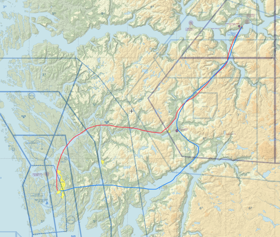
Is the red or blue route recommended from Bergen to Sogndal?