
I won’t identify the airfield, because I don’t want to embarrass anyone, but I was amused to hear an A/G operator today say "We have an aircraft in the overhead which, according to FlightRadar24, is at 2,400’ ".
That makes Pease Pottage and Bournemouth ATC college seem like an expensive white elephant ;-)
If not in contact, that at least is useful traffic info!
FR24 is commonly found running on laptops at various towers but only rarely does it get a mention on the radio 
I have heard one such mention and the guy said it very tongue-in-cheek.
It is not known in detail how FR24 works. It isn’t as simple as some think; for example about 50% of this (a GAMI test and an ASI calibration procedure) was flown with a 7000 squawk
Also, what you see on their website is not the same as what you get on the paid android and ios apps. Much more shows up on the apps, but they can’t plot the track like the website does (above).
It would be outrageous if the CAA busted tower staff for using FR24, given how NATS and others have shafted everybody by wanting c. 100k/year for the radar feed.
Peter wrote:
for example about 50% of this (a GAMI test and an ASI calibration procedure) was flown with a 7000 squawk
Mode C or Mode S
Mode S.
FR24 shows nothing for Mode C. It needs Mode S or ADS-B.
Of course this is an issue for anybody with a Mode S transponder who wants to be anonymous: they have to fly with it totally turned off because turning on the transponder (even just for Mode A – another useless thing to be doing) always radiates the Mode S bit. In UK Class G you can do this (much to the irritation of many others) but it does limit things elsewhere.
So what the operator has actually done is that he identified an airplane overhead visually and then took the altitude readout from FR and quantified that information.
Like that it is just about acceptable, as most people know that positions displayed by FR are not always accurate, especcially if they are non-ads-b airplanes. Altitude readouts on the other hand are, but they would be probably not QNH corrected. Which of course would make a statement “at altitude xxx” wrong unless the QNH is 1013.
I’d be very wary using FR for anything but pure entertainment. A lot of airplanes show astonishing position inaccuracies, vanish into thin air and re-appear and so on. It can be informative yes, but unless taken with a bucket of salt, also quite misleading to point out traffic this way.
While I generally agree about “be very wary using FR for anything but pure entertainment”, I cannot see any fault with the A/G operator. At the contrary, giving all possibly relevant info, with an indication of the source/degree of reliability, is exactly what I expect from them – and indeed it is what I almost universally get. Indeed my official FIS is commonly heard to warn people of “traffic at your ten o’clock, crossing left to right, indicating 2000 feet” or such.
Which of course would make a statement “at altitude xxx” wrong unless the QNH is 1013.
He could easily do the correction however. If say FR24 reads 2000ft and the airport QNH is 1023 then the aircraft will be at 2300ft. If I got that the wrong way I should probably hand in my PPL 
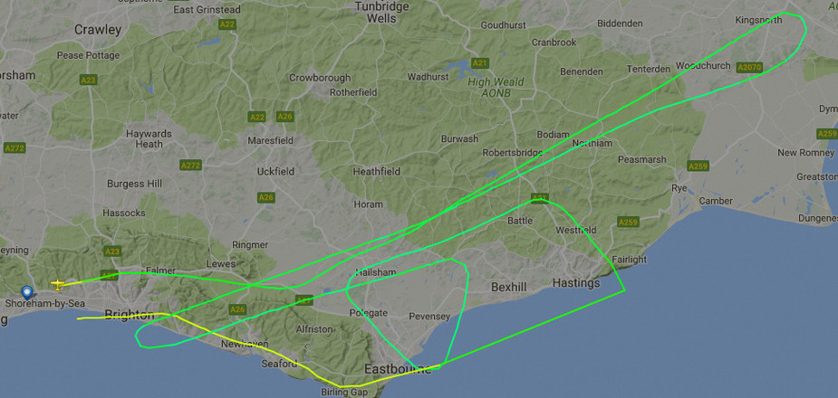
FR24 is not bad where there is reasonable radar coverage (almost nobody in light GA is radiating ADS-B) – example
Mooney_Driver wrote:
he identified an airplane overhead visually and then took the altitude readout from FR and quantified that information
Well…the aircraft in the overhead was actually in cloud.
But I am really not criticising the a/g operator the tiniest bit. It just amuses me how the uncertified world is taking over, mainly because approval and regulation has become so burdensome and expansive.
Timothy wrote:
Well…the aircraft in the overhead was actually in cloud.
Well even better reason, although at least we know he was transponding, which is a relief.
A similiar system operates for boats, and a similiar computer / app based system is available, but no equivalent of AT. Running the computer or
app especially in fog is an invaluable way of identifying other vessels, especially as the coverage is pretty much worldwide.
I am happy that as long as the source of the information is qualified an A/G operator can pass me any information he thinks might be helpful, but I guess there are still too many pilots that are not clear on the limitations of an A/G operator and this, as a consequence, could lead to confusion. I believe instructors should spend more time on this aspect as well as the usefullness of other aircraft passing relevant information when no one else is around. There is a busy(ish) airport in the south of England which is almost never “manned” – it is interesting how rarely other aircraft will pass information which might be relevant. In contrast I have found in the States in the same circumstances other pilots go over board to assist, usually without being asked. I sometimes wonder whether we have a tendency to assume every pilot is a sky God rather than the opposite assumption that they maybe recently qualified and glad of all the help they can get.


