It says required not mandatory, playing the devil advocate…
Why insisting on having an ADF, is it because of NDB and runway 3.3nm offset? Or the Prohibited Area ahead? Or just the classical missed segment for most ILS approaches?
I guess you can’t have an ADF/DME that are GPS derived?
I have seen two SR22 over there (on a nice day I would add), but probably they got those handheld ADF/DME now…
Ibra wrote:
Why insisting on having an ADF, is it because of NDB and runway 3.3nm offset? Or the Prohibited Area ahead? Or just the classical missed segment for most ILS approaches?The missed approach uses the NDB for navigation — thus the requirement.
Ibra wrote:
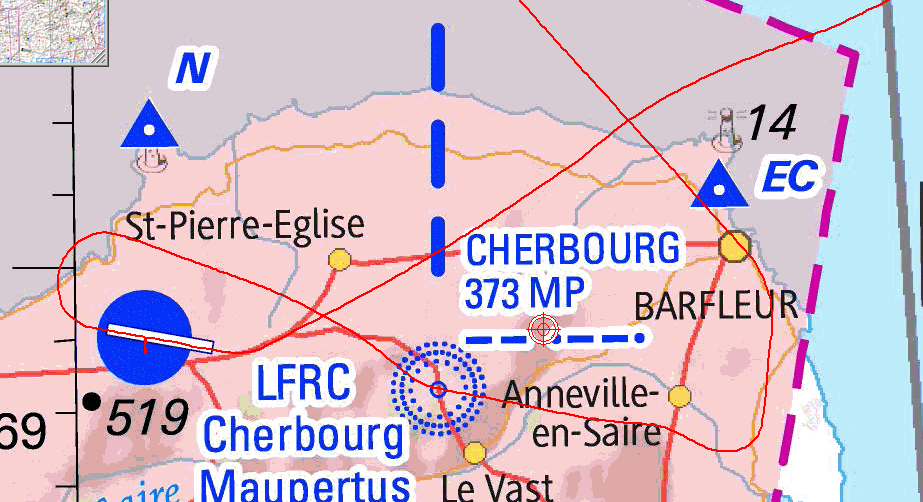
I guess you can’t have an ADF/DME that are GPS derived?There are safety issues with that which are very clearly illustrated by this particular approach. The NDB and the DME are both named “MP”, but they are not co-located! Your GPS navigator will show two waypoints with the same name. Are you sure that you will select the correct one in a high workload situation? Remember the Dundee accident…
If LFRC has a radar service in theory it may not be required unless they instruct a standard missed approach.
Dundee I believe was a case of trying a DIY GPS. An IFR GPS should load the ILS azimuth procedure from the database, with suitable warnings, giving the correct location for the elements of the approach. It remains a mystery why EASA degrades safety by not allowing GPS co location procedures as in the USA, which happens to have a superior safety record as a region.
LFRC gets radar from Deauville, until you report localiser established and then you get handed to Cherbourg Info (the tower).
When flying an ILS, I do indeed set a DCT to the airport and use the OBS mode of the GPS to give me a magenta line which displays the localiser. This is not exact because a DCT to the airport is a DCT to the ARP which half the time is the middle of the airport and not the middle of the instrument runway, but it greatly aids situational awareness especially when to expect the LOC intercept (the autopilot APR button needs to be pressed shortly before you get there).
Airborne_Again wrote:
The NDB and the DME are both named “MP”, but they are not co-located!
I think independently of the GPS story, this is a safety problem in itself. It adds unnecessary confusion. I spent some time staring at this, and wondering why it was giving me DME distances to a NDB! If I were in somewhat rushed circumstances for this approach (e.g. expected / asked RNAV GNSS but got ILS, or not enough time to properly brief due to other terminal workload), I wouldn’t trust my mind to properly read the missed approach as to MP NDB instead of MP LOC, and then wondering how the hell they could be so stupid to expect me to turn back to a radio aid that is usable only within… what is it? 7°? 10°? 15°? of centreline.
That kind of stuff happens… At night, I once (recently…) turned into a pitch dark exit taxiway, wondering why the hell the airport could be so damn irresponsible and turn off the lighting of the exit taxiway I was supposed to use! It was not a “pitch dark exit taxiway”, it was the grass next to the taxiway. I’m lucky I realised before I actually exited the runway.
I think the intention is to call the DME “MP” and actually DME=0 at the runway.
Calling the NDB “MP” also is dumb, but I bet you this exists elsewhere, and IMHO their expectation is that nobody would assume “5D MP” is the distance to the NDB.
RobertL18C wrote:
Dundee I believe was a case of trying a DIY GPS. An IFR GPS should load the ILS azimuth procedure from the database, with suitable warnings, giving the correct location for the elements of the approach. It remains a mystery why EASA degrades safety by not allowing GPS co location procedures as in the USA, which happens to have a superior safety record as a region.
No it was a hand flow ILS/DME where the pilot flew based on GPS range from the NDB which was the FAF rather than the DME and thought he was 4nm closer to the airport than he was.
Look at what happened the last time I flew to LFRC in severe VMC and strong south wind while testing the different intercept and hold features of our autopilot and GTN750 . I was flying in from the NW and was cleared to the hold at MP to allow for departing EMS traffic and later for the ILS.
Eventually we circled to land and had to do one more 360 (flown in hdg mode, not using the GTN orbit feature, with the attendant result ) on downwind to allow for further VFR traffic…
You can tell which MP we were initially aiming to hold at 
Oh well…at least we remained on the safe side of the hold!
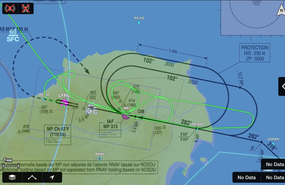
I cheated and asked for own nav to the LOC  and then a circle to land on 10