I am thinking of getting one of the programs (first time usage for me) and I wanted to compare the coverage and level of detail of both. I found the coverage of SkyDemon here but unfortunately I cannot find the coverage of EasyVFR. Does anyone know what they cover or where one can find the current information?
I also found this (a bit old) topic about SkyDemon where people on the forum discuss issues with SkyDemon in Italy and Money_Driver points out that PocketFMS (EasyVFR) has more detailed information.
So what is the current state of the two applications? Which one currently provides more/better data, charts, notams, etc.?
It’s a religious question. SkyDemon is the market leader. EVFR has a rather small share of the market it seems.
SkyDemon have more or less solved the problems with the Italy CTRs, about a year and a half ago or so. Still not perfect, but OK.
The issue with the italian TMAs will soon be resolved though because they are in the process of redesigning their TMAs to a more ICAO compliant one. Rome has already been done. Milan will follow soon. More details see here: http://www.euroga.org/forums/flying/3689-italy-re-designs-its-tmas#post_60878
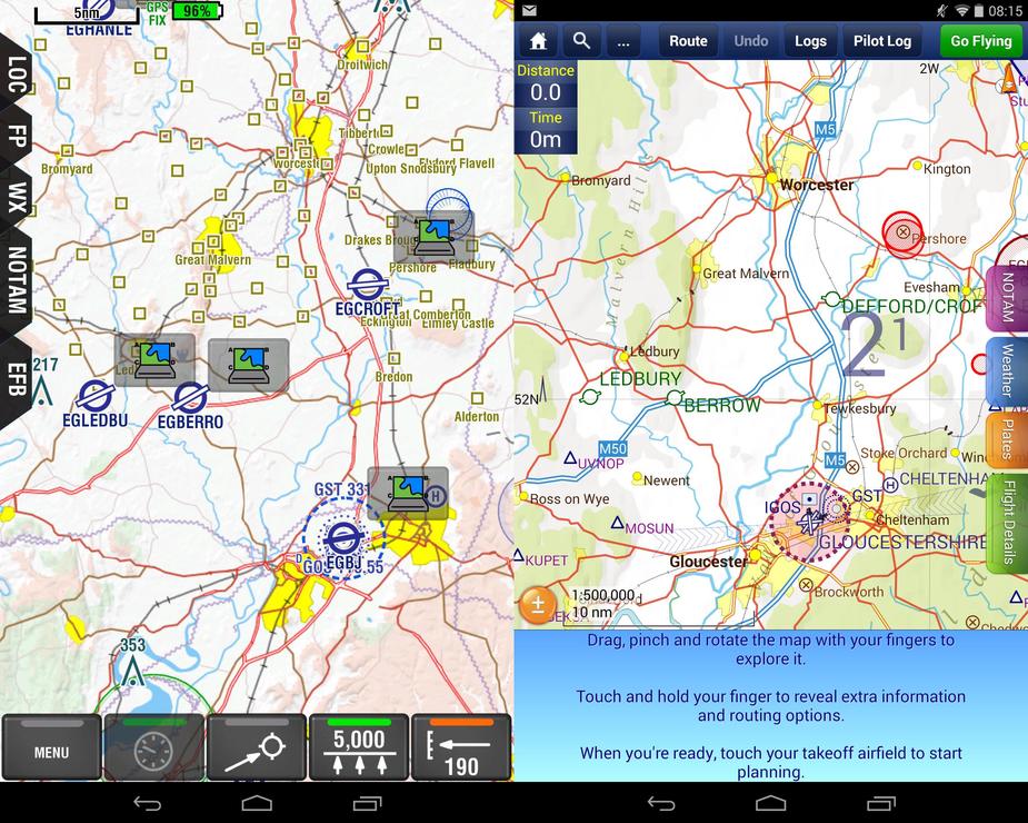
On this picture from October 2014 it looks like EVFR shows some additional details, e.g. some squares (I don’t know what they mean) and high voltage lines. However they also seem to clutter the map with information which is probably not very useful.
EasyVFR hands down. You can unclutter at will and use ICAO background maps which rather often can be very useful when talking to ATC/Information. Skydemon is OK if you are flying a B737, but has none of the small airports. EasyVFR is more clunky though, but seems to become smoother and smother for each update.
LeSving wrote:
but has none of the small airports
Wow, I thought they both have all airports for GA.
Do airport VFR charts come with any of the two?
Skydemon is OK if you are flying a B737, but has none of the small airports.
That is not my perception of SD. I think it works well for all VFR and many types of IFR but arguably finds “737” IFR a bit much.
Skydemon is OK if you are flying a B737, but has none of the small airports.
In 2 years of using Skydemon, I have never encountered such an issue. Not only do they show all ICAO-coded airports, but also the numerous microlight airfields that exist eg. in France.
I’m overall very satisfied with Skydemon. What I miss is IFR functionality other than the current airway depiction (eg georeferenced approach charts) and a possibility to overlay weather radar data.
I love SD. For basic VFR flying offers a very complete trip kit.
You can filter things extensively, and when I have had an issue like a non displayed airfield it’s because a filter has been set and.not because SD doesn’t have the data. Otherwise I have seen every airfield, even closed ones.
Vladimir,
First, I should put my cards on the table, and state that I’m part of the PocketFMS beta crew. So you should know what when reading my comments below.
EasyVFR coverage is basically, Europe as far east as the Russian border. Australia/New Zealand, USA & Canada.
PocketFMS has been making moving map & flight planning software since 2003 & SD since 2009.
Both systems come with AIP approach charts. DFS charts are an additional purchase in both systems. SkyGuide is available and an additional purchase in EasyVFR. I don’t know for 100%, but assume it’s available as an additional purchase in SD too.
Both have their own VFR background charts. SD’s claim theirs are clearer. EasyVFR’s provide more detail (but it removes details as you zoom out, and you can change the size of map objects if you find them too big..or indeed too small). If you want an ICAO (paper chart) overlay on top of the built in maps, then only EasyVFR offers this, but it is an additional purchase.
Both offer NOTAM briefings. I believe that EasyVFR’s briefing is more in line with how pilots brief. It allows you to apply gross filters (eg to hide IFR NOTAMs or NOTAMs that cover a whole FIR), and to see the remainder on a list. You can then review the list, dismissing (hiding) any that aren’t relevant to your flight, and then see just those that remain (which you deemed important) on the map. Last year SD copied our ability to hide NOTAMs (for at least some NOTAMs), but they still have a very different work flow. We also sync the NOTAMs hidden across all your devices, so you can do the briefing on one device and it will update to all your devices.
You can also take a print out (as part of our printed trip kit) of your NOTAM briefing, or store a copy in the cloud, so that you can later produce a copy of it if needed.
I believe both get the NOTAM data direct from EuroControl on a Business to Business connection, so NOTAMs are fit for flight planning.
Both include METAR & TAF and wind aloft data. EasyVFR includes hour by hour forecasts for the following 48-72 hours, which are overlaid on the map and can be played as an animation.
SD produces a “live plog” which updates as you fly. EasyVFR does a “Trip kit” which produces a PDF of all your preflight documents (plog, comms, weather maps, NOTAMs etc) which you can either store in the cloud or print off (we make printing from tablets easier).
EasyVFR is available on Windows/Mac/Android/iOS/WP8. All platforms are identical with identical features except WP8 which lacks a few items that the others have.
SD is available on Windows/Android/iOS, but I believe that there are some features that are only available on certain platforms.
The little boxes that you refer to are small town/villages. Having them makes it easy to plan view know places if you want to. The disappear as you zoom out and you can make them smaller if you wish.
Both allow you to file flight plans (it’s free with a full PocketFMS membership, you need to pay with SD as far as I’m aware, but I don’t think it’s very expensive—something like £1 per flight plan).
Both do relative terrain shading (SD copied that from us this year).
That’s probably the closest I can come to answering your questions in a balanced way, without trying to turn this into an advertisement. But if you do have any other questions about EasyVFR, feel free to ask or indeed send me a pm.
Colm
Vladimir wrote:
Wow, I thought they both have all airports for GA.
It depends what you mean by GA. Flying the Cub in strange places, SD is not it. Besides, looks like most people around here use Airnavigation Pro, maybe because of the abundance of maps and configurability, or old habit, I don’t know. We have it installed on an iPad in one of the club’s plane, and it does the job perfectly well.