A WAAS GPS satisfies the navigation equipment requirement in 91.205(d)(2) as would a VOR/ILS receiver. A TSO C129 GPS may only be used for supplementary navigation, IOW a VOR receiver would still be required equipment for IFR in the US. The AFMS will have a limitations such as: “The aircraft must have other approved navigation equipment appropriate to the route of flight installed and operational.” So if the aircraft was just equipped with a GNS400W, that would be fully legal to fly IFR, but a GNS400 would not be unless the aircraft were also equipped with a VOR system
That is my understanding as well in EASA land under NCO (PIC decide on his route, the route require a range of equipment specs to be carried, the AFM will have route approval for those specs or any legal backups)
500nm is lot on GPS  well there is max off-route DCT on FPL validation at Eurocontrol (about 200nm which is max range of VOR), bellow 10kft if you ask for 200nm direct, FIS/ATC will tend to remind you will be going outside controlled airspace or radar coverage as things gets patchy in the typical 8kft normally aspirated piston cruise
For backups it’s mostly common sense: solid panel full of backups with modular instruments is way better but one has to adapt his backup & minima to his equipment, in theory, one should no depart with LPV & ILS at minima as 99% of GA aircraft don’t have two glideslope indicators in case the GS display fails…
Ibra wrote:
so theoretically now one in US can fly “GPS only” without Radar coverage and without VOR/ILS in his panel?
The main regulation for IFR required equipment is 91.205(d)(2) which simply states:
Two-way radio communication and navigation equipment suitable for the route to be flown.
A WAAS GPS satisfies the navigation equipment requirement in 91.205(d)(2) as would a VOR/ILS receiver. A TSO C129 GPS may only be used for supplementary navigation, IOW a VOR receiver would still be required equipment for IFR in the US. The AFMS will have a limitations such as: “The aircraft must have other approved navigation equipment appropriate to the route of flight installed and operational.” So if the aircraft was just equipped with a GNS400W, that would be fully legal to fly IFR, but a GNS400 would not be unless the aircraft were also equipped with a VOR system. Radar is a separate issue and not an equipage issue. When operating on random routes (meaning not on airways), radar monitoring is required. There is an exception for GPS equipped aircraft in that radar monitoring is not required when the aircraft is operating on a point to point random route under 500 NM and the points are in the DB. A route that is direct to a fix is a random route, but does not lie along a point to point route and it would require radar monitoring, even if GPS is used.
Edit: A point to point route when filed in a flight plan can be checked in the ATC computer so that the assigned altitude is at least 1000 feet (2000 feet in mountains) above all obstacles and terrain within +/- 4 NM of the center line of the route. This is the MIA (Minimum IFR Altitude).
Why not? in clouds & oceans it’s different but at least when flying with ground in sight, visual navigation a rock solid contingency plan if GPS is lost (DR nav is even considered far superior and way more robust by some pilots & regulators than equipment as the latter can fail)
Maybe it’s different for Class Alpha airspace as one can’t fallback to VFR? but I doubt visual navigation is not an enough backup to loss of “VOR only” or “GPS only” operations…
@lbra I don’t think it means ded reckoning!
Thanks @NCYankee for the background, so theoretically now one in US can fly “GPS only” without Radar coverage and without VOR/ILS in his pannel? (subject to higher minima for RNP approach only without VOR/ILS and max 500NM for cruise filing)
NCO.IDE.A.195 Navigation equipment
It give a lot of room for having a contingency plans? it’s up to the PIC to figure that out?
I doubt it means: to fly IFR in CAS in IMC you need Radar, VOR, DME, ADF…
The same for planing GPS only, from Oct2022 you can fly on GPS alone but you have to sort out the mess
NCO.IDE.A.195 Navigation equipment
Aeroplanes shall have sufficient navigation equipment to ensure that, in the event of the failure of one item of equipment at any stage of the flight, the remaining equipment shall allow safe navigation in accordance with (a), or an appropriate contingency action, to be completed safely.
Ibra wrote:
In Europe, I doubt the operator needs “Radar” & “RAIM” as prescribed by FAA?
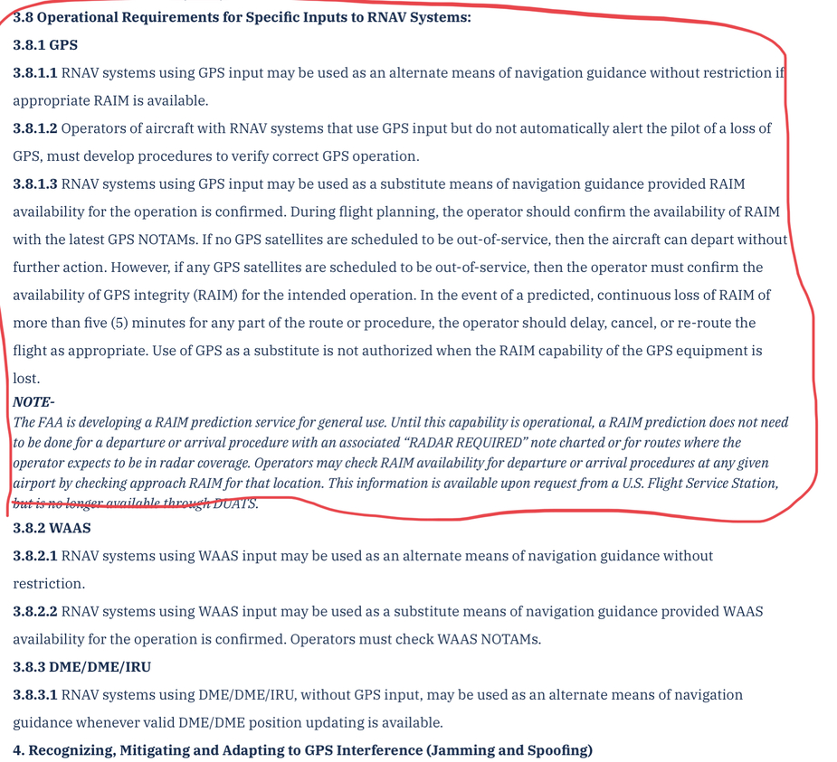
If you are using the US AIP source to indicate that RNAV requires Radar, this is a misinterpretation of what the AIP is saying.
NOTE−
The FAA is developing a RAIM prediction service for
general use. Until this capability is operational, a RAIM
prediction does not need to be done for a departure or
arrival procedure with an associated “RADAR REQUIRED”
note charted or for routes where the operator
expects to be in radar coverage.
This is outdated material. Unfortunately, the US does a poor job of maintaining its AIP. The FAA has (past tense) provided a RAIM prediction site for many years and has added to it in 2020 to support the ADS-B Out mandate for some aircraft that are not fully compliant or are not equipped. An equivalent to the above statement does not appear in the AIM or in current advisory guidance. The note “radar required” only appears on some SID, STAR, and approach procedures. This guidance only applied to excuse RAIM being needed for a SID .or STAR where radar was available. At one point, the FAA would not issue a clearance to aircraft to depart IFR unless the departure airport was within the service volume of a conventional Navaid, so 40 NM of a VOR unless radar surveillance was provided. Once RNAV approaches began being used, it became possible to land at an airport only served by GPS, but no way to get an IFR departure clearance because of lack of radar coverage. That was changed and now GPS may be used as long as the random point to point route includes at least one named point within 500 NM of the departure point.
This is from the FAA controller guidance, 7110.65Z in 4−4−1. ROUTE USE:
c. Random routes.
1. When not being radar monitored, GNSS-equipped RNAV aircraft on random RNAV routes must be cleared via or reported to be established on a point-to-point route.
(a) The points must be published NAVAIDs, waypoints, fixes or airports recallable from the aircraft’s navigation database. The points must be displayed on controller video maps or depicted on the controller chart displayed at the control position. When applying nonradar separation the maximum distance between points must not exceed 500 miles.
Current guidance is for the non WAAS GPS systems to do a RAIM check for the route before departure and to delay the flight if there is an outage expected that will last for more than 5 minutes.
The FAA does a better job on keeping the AIM current. There is no requirement for using radar when using a GPS for RNAV. The US uses RNAV 2 for enroute airways and RNAV 1 for RNAV based SIDs and STARs. A few RNAV SIDs have a RNP 1 requirement when they incorporate RF turns. RNAV 5 is not used in the US for any airway routes. RNP APCH is used for the approach specification, but the FAA has kept its naming convention of RNAV (GPS).
This means that RNAV specifications are intended to be used where surveillance is available while RNP specifications are intended to be used where surveillance is not available (or practical)
Yes that make sense and was the intention but I don’t think any country has gone with that implementation for legacy and cost reasons:
- RNAV5 Airways flown without Radar surveillance in PBN airspace (usually Echo or Golf) with reduced traffic bandwidth, I am not sure why the lack of radar is a problem for GPS equipment? but not for VOR equipment? without radar, these are subject to “additional requirements” by individual states
- RNAV1 departure & arrival are used bellow Radar MVA (or MSA/MEA) or outside Radar coverage and were not designed as RNP1 because of lack of approvals in most navigators, without radar, these are subject to “additional requirements” by individual states
I am not sure what are the “additional requirements” for every country if no surveillance is available? but few random things will come to mind 1/ two independent sources of navigation? 2/ NDB for GPS RNAV1 missed? 3/ check RAIM for RNAV1/5 during planing? 4/ plan CONV + GPS routes? 5/ fly on PLOG? 6/ plan VMC?
These are not specific to GPS equipment per say, someone flying RNAV5 Airway on his 2×VOR will also need to back it up (something like GPS?) but it seems everybody ignore this one: grandfathered right before PBN was introduced 
Ibra wrote:
Do you have a reference that RNAV5 = Surveillance environment? (Radar or ADSB)
I never wrote that “RNAV 5 = Surveillance environment”. I said that the difference between RNAV and RNP specifications is that RNP specifications have “On-board performance monitoring and alerting” and alerting, while RNAV specifications do not. This means that RNAV specifications are intended to be used where surveillance is available while RNP specifications are intended to be used where surveillance is not available (or practical)
“Radar Required” & “RAIM required” seems to appear in US rules & procedures regarding RNAV operations (including RNAV5 cruise), but these things creep into European rules & procedures, however, it seems 1/ it’s about legacy TSO129 GPS non-WAAS and 2/ FAA use RNAV to mean “RNP” and “RNAV”, which is very confusing for anybody else who uses “ICAO/PBN terminology”
Yes, this is very confusing. Also in ICAO terminology the usage has varied, e.g. RNP approaches used to be called (e.g. in PANS-OPS up to the 5th edition) things like RNAV(GNSS) approaches. This is a terminology still used by the FAA. Jeppesen and other database providers have refused to adopt to the change in ICAO terminology also outside the USA, so RNP approaches in Europe are still called “RNAV GPS” approaches in GPS navigator databases although the approach plates (both AIP and Jeppesen) call them “RNP” approaches.
In theory, RNAV 5 can only be used when radar (or possibly ADS-B) surveillance is available. So in all airspace which requires RNAV 5, radar service will be available. In enroute airspace without radar (or ADB-B) surveillance, you would need an RNP specification such as RNP 2 or RNP 4
Do you have a reference that RNAV5 = Surveillance environment? (Radar or ADSB)
“Radar Required” & “RAIM required” seems to appear in US rules & procedures regarding RNAV operations (including RNAV5 cruise), but these things creep into European rules & procedures, however, it seems 1/ it’s about legacy TSO129 GPS non-WAAS and 2/ FAA use RNAV to mean “RNP” and “RNAV”, which is very confusing for anybody else who uses “ICAO/PBN terminology”
https://www.faa.gov/air_traffic/publications/atpubs/aip_html/part2_enr_section_1.17.html
In Europe, I doubt the operator needs “Radar” & “RAIM” as prescribed by FAA?
The only thing, I know is you are 100% legal to fly PBN (RNAV & RNP) with “GPS only” in your FPL without radar coverage, of course, if it’s TSO129 box and no-SBAS, you have to check RAIM for RNAV1 (or whatever leftovers from PRNAV) and RNP0.3, if it’s good you fly
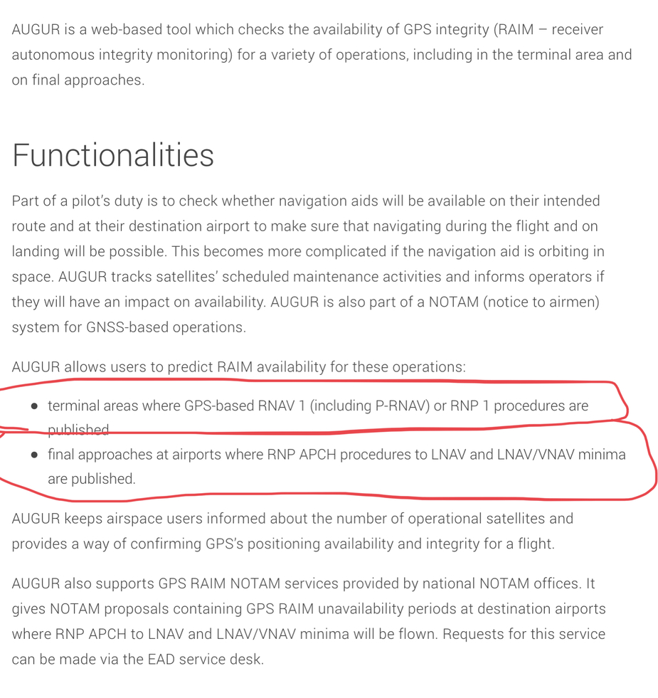
https://www.eurocontrol.int/online-tool/augur