I have read (source: Honeywell RNP presentation) that all LPV approaches (using SBAS WAAS) are free of Altimetry/temperature related error, since they rely solely upon a GPS-derived Alt reference. (The same document quotes SBAS WAAS as providing a lateral accuracy of “1-2m” and for the vertical, “2-3m”).
However, in my recent Garmin G500 & GTN750 training (delivered by Garmin), we were specifically told by the Garmin instructor that all RNAV approaches use Baro Alt. I did stick my hand up to query this, but was assured by the instructor that his statement was correct.
Does anyone know which of these statements is right?
Kind regards
Bob
Bob wrote:
Does anyone know which of these statements is right?
I would say: No. You can stick a Garmin GNS430W into your panel and fly LPV approaches. It has no connection to an altimeter or other source of static pressure. How can it use barometric altitude then?
No, it is rubbish. The only Baro alt is the minima.
Thanks @what_next. That’s a good point but our panel uses an integrated Garmin air data computer and this is what we were being trained on. The instructor is an active FAA IR pilot and really knew his was around the Garmin equipment – and he was really emphatic on this point. I have his email, so I could write to him – or I can try an RNAV approach in VMC and fiddle with the Baro alt to be sure!
Bob
One possible confusion is that the GNS-W or GTN can fly an APV-Baro VNav approach but will use GPS altitude instead of baro. It can only do this if the database has been programmed with an additional ‘a’ in the ARIN424 approach coding, and this depends on whether the local airspace regulator permits it. Germany have some of these approaches available.
@wigglyamp you mean an LNAV/VNAV approach. This can be flown either using WAAS for the vertical component or a barometric vertical component. Yes there are coding issues which can prevent them being available for WAAS use even when you have WAAS but when available on a WAAS unit they only use GPS.
Mine is also approved for BaroLNAV/VNAV, which means all the approaches show and it will use Baro input if WAAS GPS is not available. But he can’t have meant that.
This has nothing to with LPV.
Hello,
I fly a C182 with SBAS enabled G1000 and trained on it to get my CBIR.
Here is the Jeppesen map for LFRN, RNAV (GNSS) 10 :
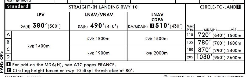
3 kinds of approaches :
LPV is a 3D approach only guided by GPS, horizontally and vertically, no temperature related
LNAV/VNAV is also a 3D approach, vertical guidance is barometric (baro-vnav) temperature limitation apply (-10°C in this case)
LNAV CDFA is 2D approach with only a horizontal guidance (like VOR approach)
LimaVictor wrote:
LNAV/VNAV is also a 3D approach, vertical guidance is barometric (baro-vnav) temperature limitation apply (-10°C in this case)
No, LNAV/VNAV can be either using GPS or Baro for the vertical. If using Baro the temp limitation applies.
I don’t get the instructor’s comment at all. LPV is GPS-guided laterally and vertically!
Obviously one flies on baro altitude all the way to the FAF, in all instrument approaches. But once on the “GS” it is
However there are bizjet systems where the FMS (Collins Proline in the one I know of) generates a fully synthetic “ILS” to (apparently) any runway in the database. I don’t know if this is generated from the Jepp database using the +V data (a straight line from FAF to MAP) and these may be flown using baro guidance for the “GS”.
I agree : LPV is GPS-guided that even takes into account an angular guidance with increased sensitivity as getting closer to the ground.
VNAV utilizes a GPS created glideslope based on WAAS or baro-VNAV systems. For instance, I lfy with a GNS430W that never uses any baro input as it has no connection to any barometric source as what_next stated. @Bob tells us that the GTN750 has this and you need to know how it is handled. Which one it uses on an approach: GPS-related or baro-VNAV since baro-VNAV stays temperature limited and RAIM has to be checked.?
LNAV/VNAV approaches give lateral guidance only. RAIM must be checked when not using WAAS equipment. Here one has to know if baro-VNAV is used instead of WAAS. And the instructor seemed to emphasize that your GTN750 always uses baro-VNAV in place of WAAS.
I read that there are LNAV+V approaches that are implemented depending on the manufacturer. It includes artificially created glide path for advise only. Then barometric altimeter will be the only altitude reference admitted in order to respect any altitude restrictions.
Perhaps anybody may correct me if this is wrong: baro-aiding is used as an integrity augmentation which gives the possibility to use a GPS independant source to give guidance. Thus, it requires only 4 stallites + the static source to detect any anomaly. I reckon that this is the reason why the GPS uses primarily a baro-VNAV are used. I heard somewhere that LNAV/VNAV approaches existed before WAAS and at this time you needed a certified baro-VNAV system to fly those apparoaches to the minimums.