There was another crash in the US at the weekend. Setting up for approach, when engine started vibrating, then quit. Crashed on a house, killing the three on board. From Live ATC, he reported – ‘I am gliding in IMC’. I appreciate it is probably the nightmare scenario, but does anyone have any sage pieces of advice if this were to happen?
A major argument for CAPS (or a second engine) – I have neither.
I always run Skydemon on the ipad which may indicate an area of fewer buildings, but the options are very limited
The controller tried to guide him to a highway, giving distance call outs, but obviously did not make it. I also understand that if you break out at 2k, then options are more in your favour, rather than popping at 400’.
Depends on altitude. Absent being able to make a runway and if at say 2000ft I would slow the plane initially to best glide and fly it all the way to the ground. And try to aim for where I think open ground is – preferably an airport. As with all these situations, do not stall.
Jason, would you take a turn? My view would be as you suggest. Best glide, trim, and aim straight ahead until visual, then assess.
This is a big case for having a topo map running on some device. I have been doing that whenever crossing the Alps above an overcast. But I don’t think one can get that kind of data other than via torturous means; in my case I ripped it off from Google Terrain using Mobile Atlas Creator and run it under Oziexplorer. But the resolution is way too bad to show buildings, bridges, etc. It just shows the usable canyons
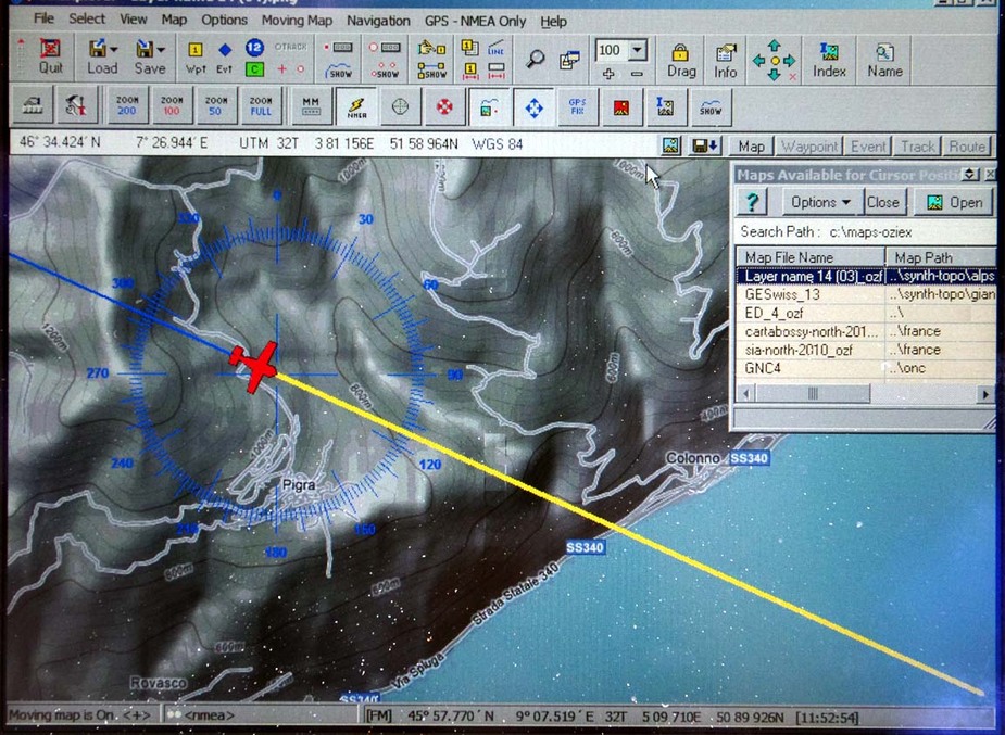
That data, for the Alps and Pyrenees, is about 5GB. It started as 50-100GB but the Ozi (OZF2) format is a lot more compact.
I think proper hi-res (ex SRTM) data is about 50GB for the world (about 6 DVDs for X-Plane). And you need a fairly fast computer to display it or, putting it another way, if there is a version of X-Plane for say an Ipad…?
Jason, would you take a turn?
I would turn if I had a reason to ie if I knew the airfield was 90 degrees to my left and I had sufficient altitude. Assuming it isn’t 0ft cloudbase you will break out and can then adjust somewhat. It would be a scenario where SynVis would be perfect (or as perfect as can be given you have just had an engine failure in IMC). A parachute however would be very handy too.
Peter wrote:
if there is a version of X-Plane for say an Ipad
Here.. Don’t think it’s similar to the big one though. However Xavion might actually be a thing helpful in this case, at least a bit. According to the description it calculates the best reachable airport (note that not always with best glide speed) by checking altitude, position, terrain, winds, etc. It will guide you to the airport through “hoops” so you can do it in IMC as well. Unfortunately works only in the US for the time being but if it is a good product it might come to Europe as well.
Xavion. That is a good product. Xavion sent an e flyer when the product was launched. I thought it a reasonable add on. But still only in the States as far as I am aware. Having a look at their site, ADS-B is only available in the States. For Europe, they suggest a manual entry for winds aloft. Will investigate further.
And Xavion not really made for a low altitude problem like the one referenced.