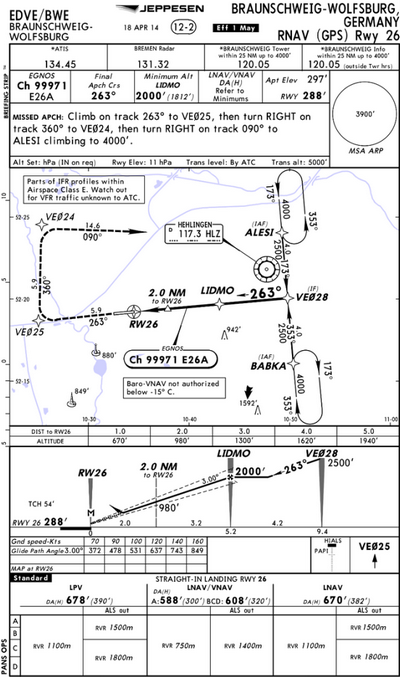
Based on another thread I pick up Peter’s suggestion to start a new one. To make our conversation a bit easier I post a screenshot of an LPV approach.
One topic in the other conversation was whether GNSS approaches need calibration flights.
Another topic was how the courses on a GNSS approach plate / terminal chart are subject to magnetic variation.
Isn’t it like this?
- The GPS waypoints do not change, because they are coordinates based on true latitude and longitude
- the courses between those waypoints OTOH are given as magnetic course – and they can theoretically change with variation
- the final course is the magnetic bearing to the runway
Hello,
as far as I know it goes like that (in Germany – probably differently elsewhere):
What is required to establish a GNSS approach?
An airfield or helipad and an obstacle survey.
Who starts the process and who pays for it?
The airfield operator.
How does the approach get into the AIP?
At some stage DFS will get involved in the process and look after these formalities.
How does the approach get into avionics databases?
The companies who provide and maintain the databases get their information either from the AIPs or directly from the people who feed the AIPs with data.
…was whether GNSS approaches need calibration flights.
Yes. Initially and then every five years. I have heard that this period may be (or already has been) extended to ten years.
…chart are subject to magnetic variation.
Yes, they are all magnetic.
Tomorrow I will fly to an airfield which is currently in the process of implementing a GPS approach to their other runway direction (the first one was installed a decade ago). They already made the foundations for the approach lights. If I meet one of the people involved in the process, I will ask a few more questions and report!
what_next wrote:
Yes, they are all magnetic.
Not true, the final approach segment data block does not contain anything dependent on magnetic variation. The final approach course is determined by LTP lat/lon and FPAP lat/lon.
A GPS receiver computes true courses, and then converts them to magnetic courses for display only using the world magnetic model. Guidance does not involve magnetic variation anywhere.
Then why is the Final Course of EDMS 274 degrees on both the VFR approach chart and the GPS RNAV approach chart?
tomjnx wrote:
Guidance does not involve magnetic variation anywhere.
I think Tom means you don’t have to bother about variation yourself, just fly the given heading/track.
Yes, but if the Course given is the same on both the VFR and IFR approach chart then that number is a magnetic course.
But maybe I’m just a bit slow … :-)
tomjnx wrote:
Not true, the final approach segment data block does not contain anything dependent on magnetic variation.
Sure. But the number „263“ on the chart above is a magnetic track. And this is the only one the pilot will see.
tomjnx wrote:
A GPS receiver computes true courses, and then converts them to magnetic courses for display
Doesn’t that mean the same? At the end you see magnetic course. I.e. the GPS has the coordinates and thus the true courses but for display shows them magnetic. The charts also show them magnetic. Hence the machine knows everything true but shows everything magnetic; the pilot sees and flies magnetic.