For example here

Does the obstacle clearance assume that these heights are being checked as you descend?
Or is some “reasonable” tolerance being applied to these
and that is all that’s needed?
Obviously if you fly a GS of 100kt and a VS of -797 fpm then you will be exactly on the “glideslope” but that’s impossible.
I am not sure I entirely understand your question but yes, the steps are integral. You cant go below the 1490 step until passing 3.0 nm. But it is meant to be flown as a CDFA. Manually that can be challenging but you should still not go below the steps to any meaningful extent. The obstacle at 854’ is clearly limiting. As with all approaches, there are tolerances applied. But we should never use these in practice.
Not instrument rated but nothing prevent you to do the old fashion “dive and drive”.
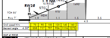
So at 2.9NM you could be at 970ft, if you had airbrakes efficient enough to drop 520’ in 0.1 NM
Xtophe wrote:
So at 2.9NM you could be at 970ft, if you had airbrakes efficient enough to drop 520’ in 0.1 NM
That must be the Sukhoi 26 version – its more something like 45 degree descent angle, versus 4.5 degrees. Or perhaps a precision spin from 1500 ft 
The dive and drive is the old fashioned way of non precision approach. In the pre RNAV times, the chart contained this steps with the “GS” dashed line in between. At that time we used the small table below to find the right VS. Without vertical guidance, especially in the way we fly single pilot IFR, it needs extra workload…as Jason wrote. It is still 2D approach. If your navigator capable you can fly it LNAV/VNAV. Avidyne is capable to display a requred VS (VSR) to any programmed point. Way easier to handle, If you follow that, you sray above the elevation. Always check the alt constraints before starting any app. The IFD is more advanced the my 747. The dash8 brought a bit more advance features like the IAN Approach which is an LPV kind procedure , but only to LNAV (non prec) minima, since the GS generated by the FMC, and nothing to do with satellites.
Step-down altitudes definitely need to be checked and care needs to be taken in the case of LNAV+V mode where an advisory glideslope is computed as, depending on the model, intermediate step-down altitudes are not considered. There was a recent accident in the US as a result – I am trying to find the relevant link for reference.
There are many NPAs without step-down altitudes if there are no relevant obstacles.
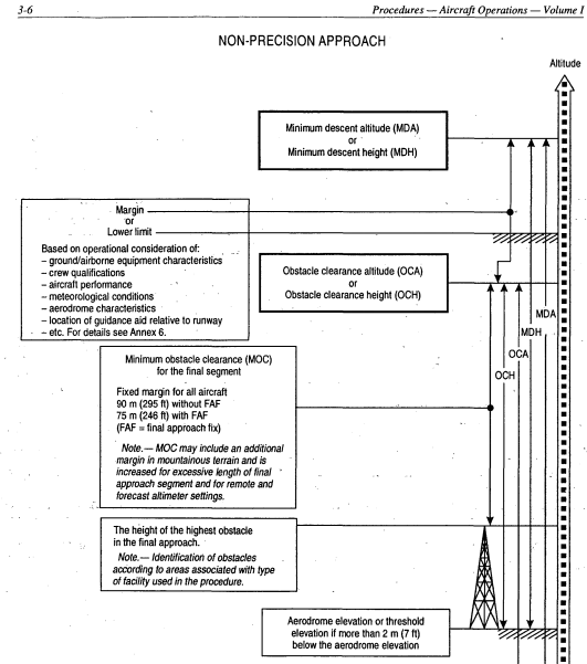
ICAO DOC 8168 is the worldwide accepted ref for procedure design. Any deviations should be published on the chart. Following are extract from m an earlier version, but if you do not have access these data are also published in Jeppesen Airway Manuals (approx 250ft minimum obstacle clearance)
But this is reduced near the edges of the protected area
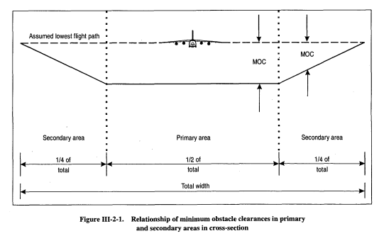
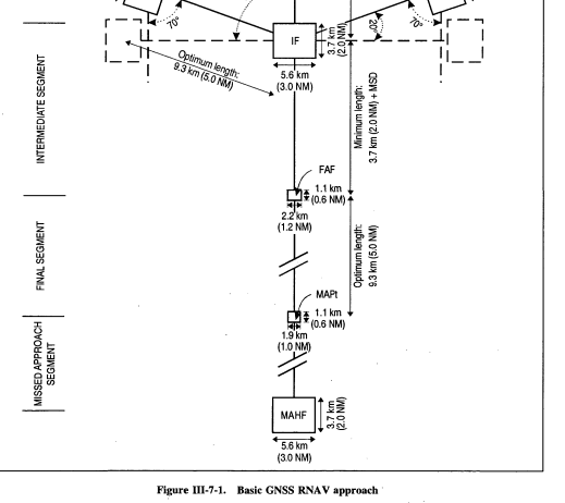
The total width of the protected area in the final approach segment is 1-1.2NM for a NP GNSS RNAV approach
So if your navigational accuracy is good and you are adhering to step-down fixes, and your altimeter error is 75ft, plus another 30ft for 1mb QNH error then you could hit an obstacle if flying around 150ft indicated below published step-down fixes. If you are less than 100ft below then you should still clear by only 50ft, which is not a lot to clear by in IMC…so yes, even though at low alts I know my altimeter error is 20ft, I’d rather stay within 25ft of the fixes’ published altitude
The yellow tables in Peter’s example are not part of the procedure design – they are advisory!
The altitudes in the profile view are part of the procedure design.