
Sure… unfortunately the SigWx was dumbed down 2-3 years ago to
But, you don’t need CBs to get severe turbulence. So I have not used the SigWx for years now. It’s OK for deiced jets, which is the principal user of the service.
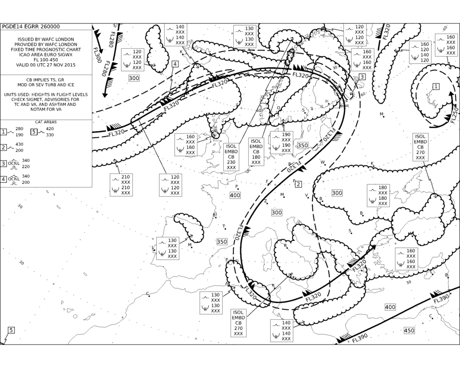
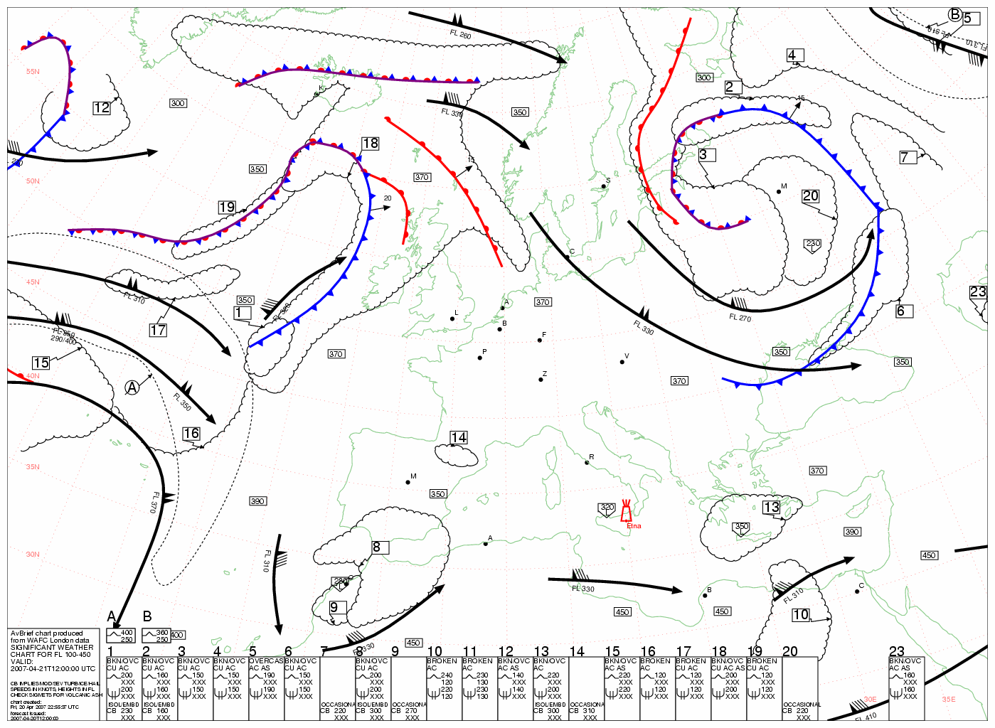
I guess the main reason they don’t show fronts is that the map is for a large altitude interval (FL100 – 450) and you can’t say the location of a front over such a range, am I right?
But you can look at the low-level map (such as the one below) and it will give you the front location…

I have reasonable experience with the reliability of both of these, although I sometimes feel that they keep too much of “safety margin” in producing the significant weather charts for FL100 and above. The issue with any more accuracy of forecasting of the “suddenly appearing build-ups” is that they sometimes cannot be reasonably forecasted even an hour before they appear / so we are left with the Eyball radar to avoid them. I don’t have enough experience with stormsope yet. Many people swear by them. Has anybody here made any bad experience with stormscope, where you would have hit severe convection/convective turbulence without the stormscope showing any warning?
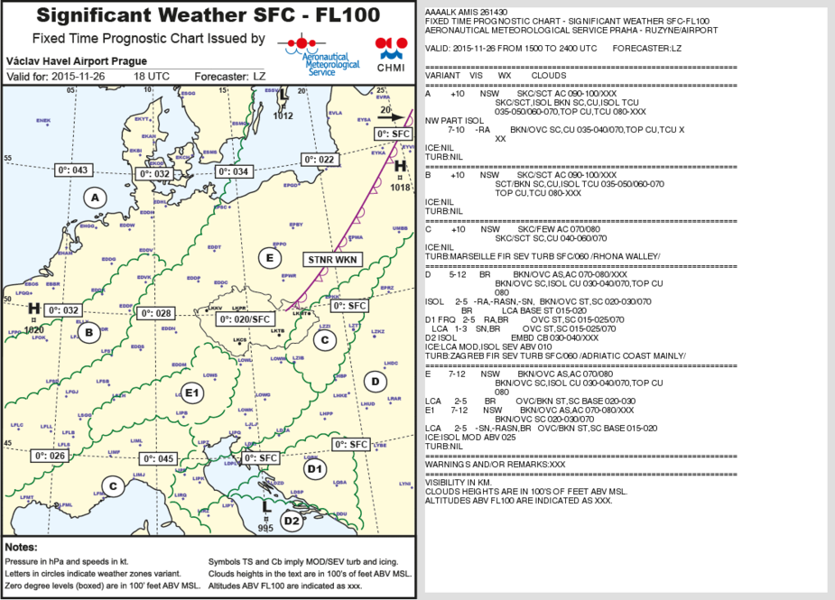
this is the high level chart
Centurion_Flyer wrote:
I guess the main reason they don’t show fronts is that the map is for a large altitude interval (FL100 – 450) and you can’t say the location of a front over such a range, am I right?
As far as I remember from my IR theory, the fronts on all charts are drawn at the place where they reach the ground. So If you fly higher, you need to project it into the direction where it moves, or actually according to what you have learned about the cross-sections of different types of fronts.
But I stand to be corrected, maybe for a chart which has a base higher than ground level, it doesn’t make sense to draw the front at all?
Yes; MSLP charts show the surface positions.
The SigWx charts used to show fronts. I have some in my old trip writeups e.g. here and here. The last one was produced by Avbrief and I believe they even used software to draw the fronts. Then ICAO mandated the removal of the fronts so they had to strip them out. A year or two later came the ICAO-mandated removal of info in regions were CBs were forecast.
There is a guy here who knows ALL about this 
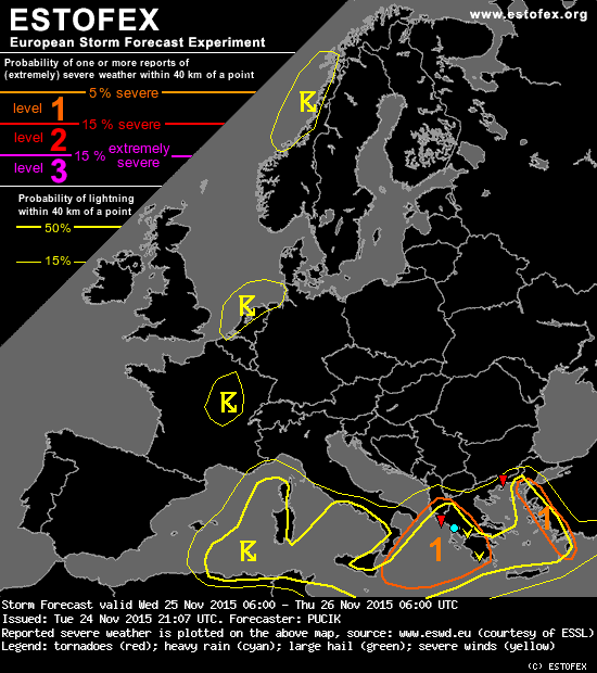
But the isolated or embedded CBs still show on the SigWx charts right? And there are also Fronts & Surface Pressure charts produced, even by the UK Met Office with a rough forecast as far as 3 days away and shorter than that. So you can have a look at the different Fronts & Surface Pressure charts (if available for your area) and see over time how fronts are forecasted to be moving to give you a rough picture to start with in the first place (although I don’t look at these charts myself very often). Or have a look at the European Storm Prediction chart (Estofex).
I have not a big problem flying through even some frontal weather, but not through embedded or isolated CBs and especially thunderstorm clouds of course. So, stormscope in combination with on board satellite based radar can help here to stay out of the soup.
I personally use a Thuraya satellite setup with external antenna to bring me the latest charts, sat radar overlay, Sigmets, METAR and TAF right into the cockpit. Then in some areas in Europe ATC has a radar overlay available for their radar screens. Such is the case in The Netherlands with e.g. Amsterdam Radar (not with DutchMil). In that case I would even fly in between some forecasted thunderstorm activities enroute to e.g. Rotterdam using the stormscope alone with a way out and ATC giving me some advise as well and with the knowledge that that they can and do, but it would feel so much better to just have a device like the ADL120 along with you as well (or some other satellite weather system such as based on the Thuraya).
There are dynamic lifted index and CAPE value charts available (GFS based) which will give you a forecast of convective activity in the area as well (for planning purposes) and there is a more or less dynamic simplified Log-P Skew-T diagram available as well that will show you possible cloud layers over time at a fixed position of some place along your planned route. The looping will show how the cloud layers are expected to develop over time and the clouds show darker if the lifted index value drops over time.
The Estofex picture is of interest as well. Have a look.
Below a short video a friend shot sitting in the back of the SR22T while I was flying inbound to Rotterdam coming from the south flying in between some thunderstorm activity to the left and right of me. I had some additional advise from ATC on the movement of the weather, but wished I would have had e.g. an ADL120 with me at that time. I did not have the Thuraya external antenna and system installed in that aircraft at that time. One thing to watch for with the Stormscope is that it is susceptible to interference from e.g. the strobe or aircraft lights. It might give you false indications that “travel” along with you.
If your IMC at least in the states you could rely on ATC to give you vectors around precip. They would also warn of no gaps in the line. Heavy precip without SS activity is not a reason not to enter but if I had my choice I would take an area with less precip. So together with ATC help and SS it was pretty safe to fly IMC with weather around. Isolated embedded was not a problem even without ATC’s help.
I dont have too much experience here in Europe. Can anyone tell me how helpful ATC (Radar) is with weather avoidance?
In most places ATC is willing to help but they would have to go and sit behind a computer and look an a basic weather radar site to help you out. If it is not busy, they might do so, but in most cases they might simply not have the time and they also have no overlay available.
Can anyone tell me how helpful ATC (Radar) is with weather avoidance?
Most European ATC will not warn you of any radar returns. The pilot is expected to request any avoidance but then they are very helpful in fulfilling your request. In this regard sometimes they are even better than US ATC. In the US they once basically told me it was looking good on their screen and I should not be such a chicken when I refused to enter IMC on the border of really bad convective weather. That would have never happened here in Germany. If the pilot says he can not fly in one direction they accept it no questions asked.
But again the pilot must get the avoidance started. I never heard “I see an area of medium to heavy precipitation 11 o’clock 10 miles”. If you do not request any new heading etc. and it is on your flight plan you fly right through the thunderstrom…
Sebastian_G wrote:
I never heard “I see an area of medium to heavy precipitation 11 o’clock 10 miles”.
Even that happened to me once, near Frankfurt. I was in the soup in a 172 trying to reach Egelsbach. Maybe that nice lady in Langen could hear that I didn’t have my IR ticket for too long at that time. It is six or seven years ago now and never happened again, so don’t count on it.


