Sebastian_G wrote:
But again the pilot must get the avoidance started. I never heard “I see an area of medium to heavy precipitation 11 o’clock 10 miles”. If you do not request any new heading etc. and it is on your flight plan you fly right through the thunderstrom…
Flying back from Denmark on a VFR flight plan, Bremen Info was quite proactive in advising aircraft flying from the North Sea Islands (Wangerooge, Norderney, etc) about a thunderstorm sitting over Oldenburg and actually advising aircraft to steer x degrees left or right to avoid the worst so I presume it’s all down to the individual controller…..
AeroPlus wrote:
AeroPlus 27-Nov-15 21:48 #28
In most places ATC is willing to help but they would have to go and sit behind a computer and look an a basic weather radar site to help you out. If it is not busy, they might do so, but in most cases they might simply not have the time and they also have no overlay available.
Not having overlay is probably the answer.
But then why is it that according to some of the others if you initiate the weather avoidance request they can do it?
Sebastian_G wrote:
In this regard sometimes they are even better than US ATC
I dont knooow about that. The US guys really know there stuff; some are even actually pilots. Pre Controller strike there were a lot more controller pilots.
In the case of German ATC it’s probably worth to point out that there is a huge difference between the RADAR frequencies and the FIS frequencies. I’ve had the pleasure to visit German ATC in 2013 at their facility in Langen.
The RADAR controller does not have weather overlaid onto their screen nor is there any laptop nearby their desk.
FIS on the other hand has a lot of additional tools available and they can activate a WX overlay to help out VFR pilots. They also can pull up VFR approach charts on their screen, have the ICAO chart as background on their radar screen, etc. That is software developed by DFS themselves as I was told.
On the other hand I did hear last year (2014) on a RADAR frequency a conversation between a pilot and ATC about turbulence in the soup. The controller did tell the pilot when to expect calmer air and to be out of the soup. So something might have been improved since then.
LFHNflightstudent wrote:
I don’t know the ADL 120 system but it seems to run on an iPad is it commercialized?
Yes it is available. Just click here
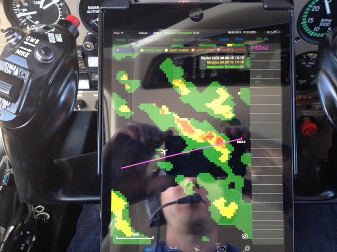
Back to the original question here are some images of a bad convective buildup close to home. The interesting thing is that this thing did not have any lightning activity. No indication from the stormscope or the data link lightning. Still I think flying through would have been a very bad idea:
I have found the on board radar to be invaluable when used correctly. There is no concept of Nextrad out in Asia, nor do ATC other than Singapore have any weather avoidance capability.
I often fly into embedded enroute IMC conditions on the strength of the onboard radar, which l consider to be an MEL item for IFR flights. The Stormscope on the other hand I have found to be of limited longer range strategic use rather then closer avoidance, giving a larger area view, and some idea of convective trending, whereas the radar is much more tactical, and can be used for navigating around weather.
I would not be comfortable relying soley on the SS for actual avoidance.
Having said all that, when conditions permit, nothing beats the MK1 eyeball. :-)
E
Peter 24-Nov-15 08:12 #18
NEVER penetrate layers of IMC if embedded convection forecasted
I agree, but how do you assess this? There is AFAIK no “simple” forecast of “embedded convection”. All one can get is proxies e.g. a TAF of TSRA would indicate nasty stuff, or the troughs on the MSLP chart.
The SIGWX chart
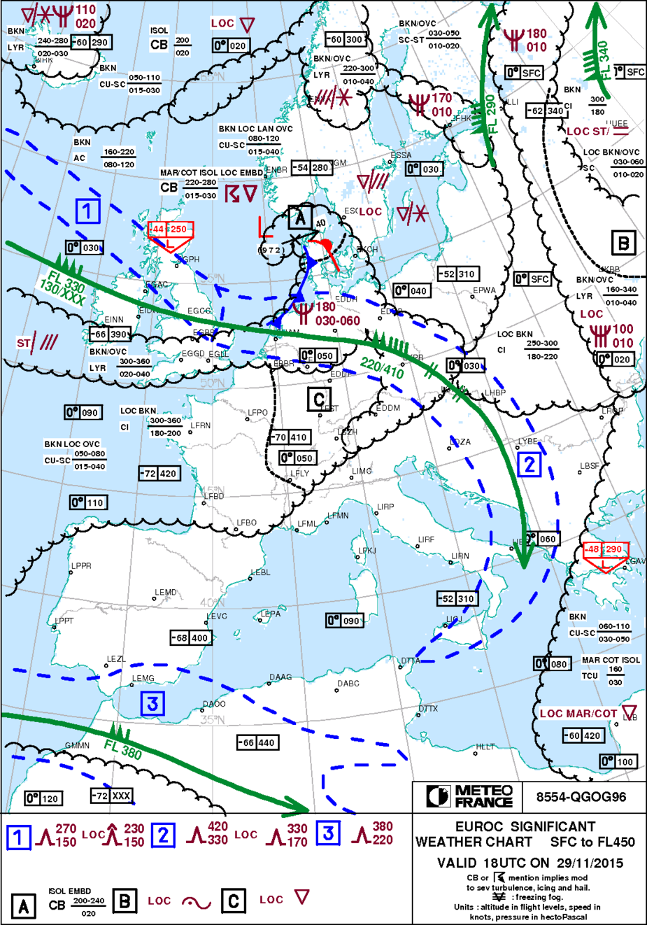
available via telegram from autorouter shows where to expect convective weather, embedded or isolated TS etc.
As I’ve no internet weather nor stormscope, I rely on that chart usually to avoid convective condition
I did a flight 2 days ago, EGHE-EGKA, in similar wx to post #1, on which the WX500 stormscope was showing isolated strikes along the route and at the destination.
The ADL150 showed nothing where the WX500 strikes were – a totally clean image. And while the flight was mostly in IMC (due to Class A base, and later ATC restrictions) I popped up through the top every few mins and could see perhaps 50nm ahead and it was just blue sky.
I did see this to the left of the track

which showed nothing on the stormscope but showed up on the ADL
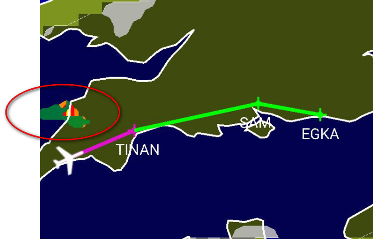
I concluded the WX500 was showing real strikes but they were much further away, which is the usual thing; it shows stuff much closer than it actually is.
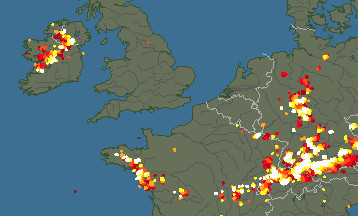
Looking at the sferics archive for the relevant time I see a big TS but a long way to the east
The Q is what to do in this situation if you are in IMC the whole time. A CB could build up pretty fast.
The ADL150 delivers delayed radar data but it could deliver much less delayed sferics data. Also is it possible for convective wx to produce lightning with nothing showing on the ADL?
I find sat strikes more useful than stormscope. Delayed but accurate with unlimited range. There’s also global coverage as opposed to sat rain data.
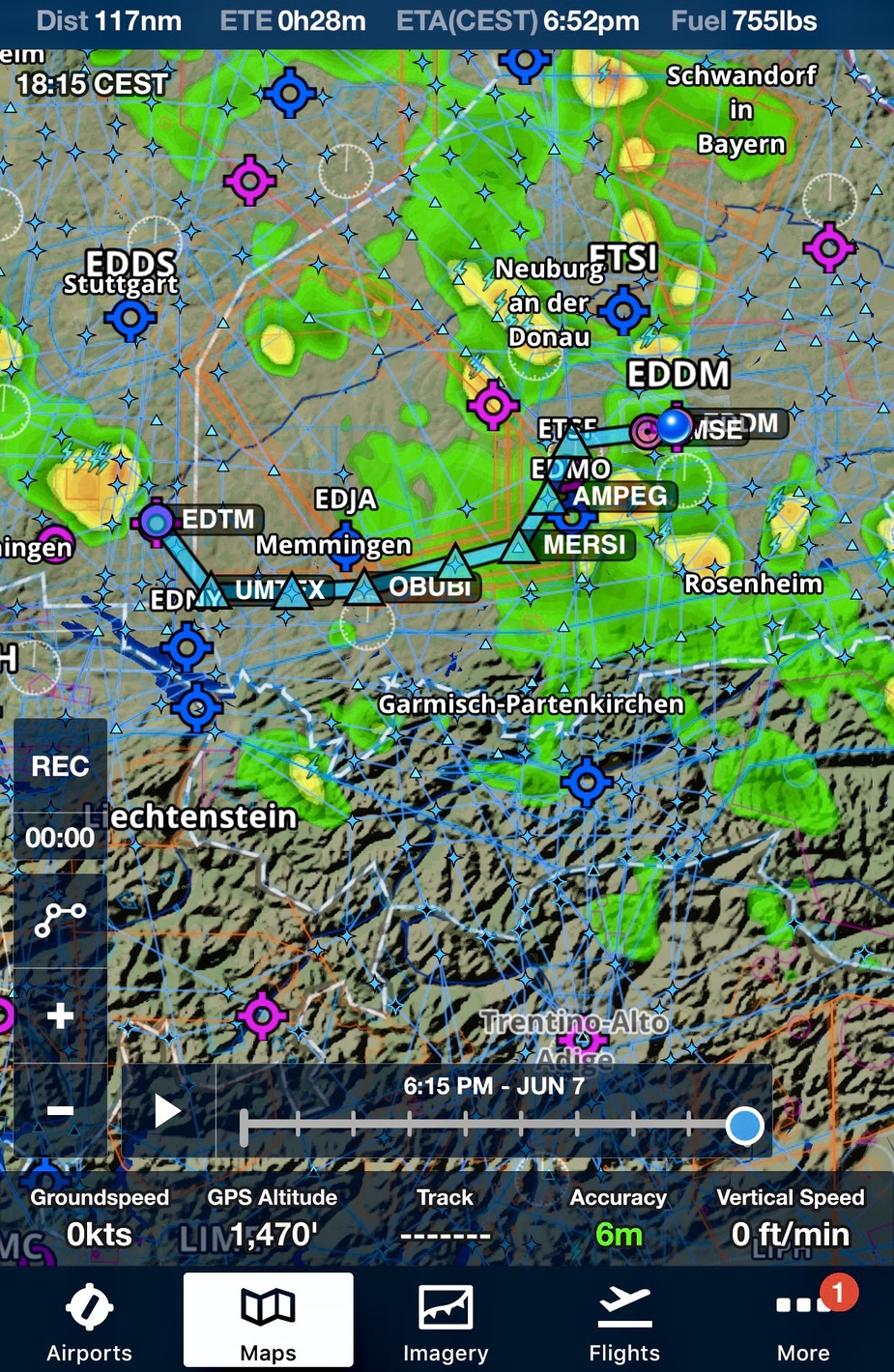
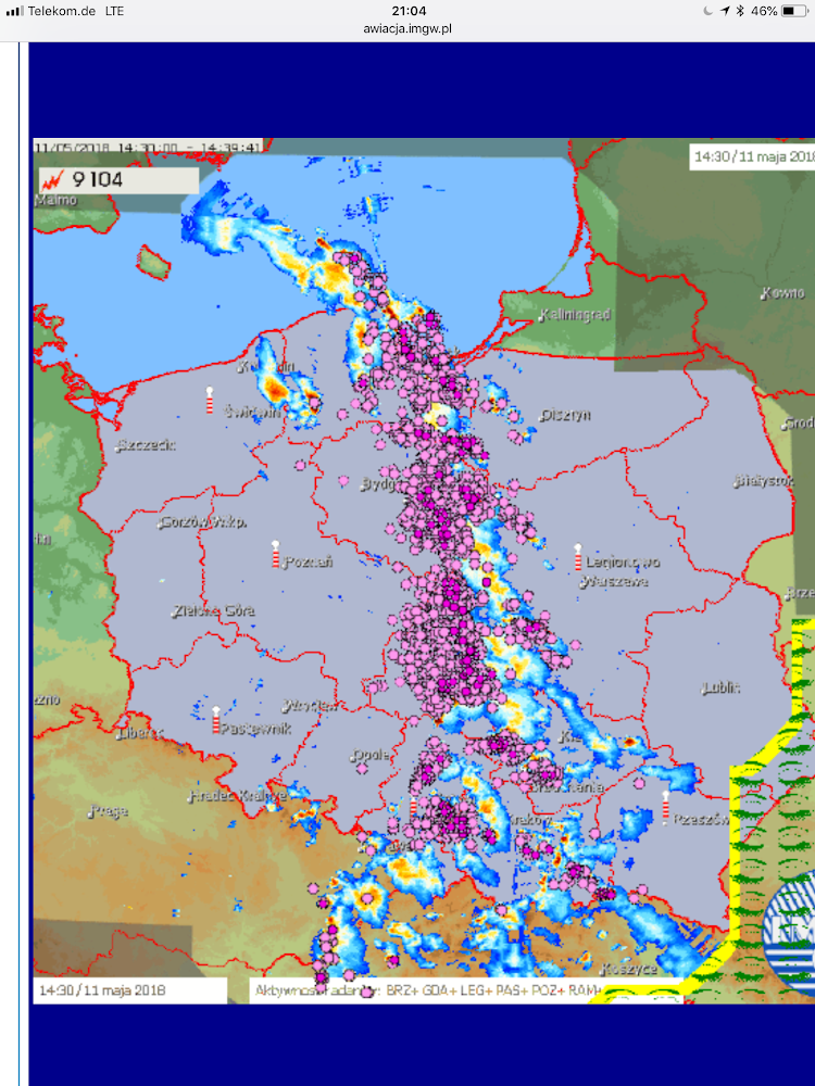
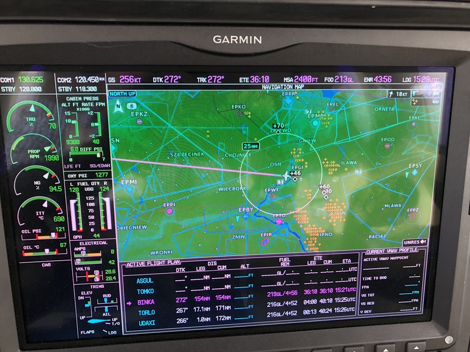
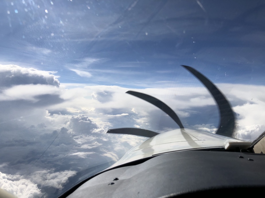
Here’s a recent trip where I had to cross a convergence line twice. First east to Warsaw, than back west to Heringsdorf. Maybe normal thing for experienced pilots, but for me a challenge.
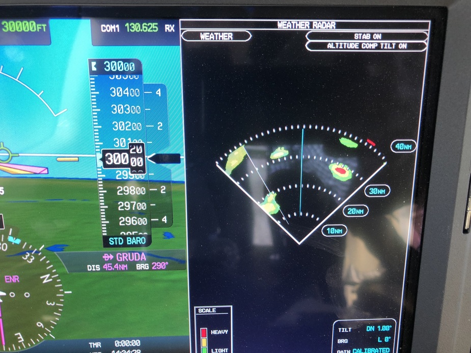
The thing is however that you are at, what, FL300 in that pic? I doubt one would want to dodge those buildups at say FL150, using the ADL, but maybe people do. And many of them will be producing strikes.
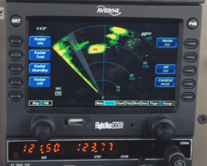
It is very difficult without RADAR. I posted on PPL/IR last week a short flight I did from Munich. Download radar was fine but you needed real time to have any comfort.