To answer your questions: as mentioned, there is the German low level enroute chart (as published by DFS) which on its back side, shows the MVAs. I don‘t believe this side of the chart is published in the online AIP, but I would have to check again.
But you don‘t really need it in order to get an idea about MVAs. As a conservative approach, take the max ground elevation (within some reasonably sized quadrant) and add 3000 feet to that. That gives you the MVA. (In terminal areas, the MVAs will be lower, but that won‘t really help you on an extended cross country.)
With the above statement it would appear that IFR flight through “winter (and even in spring)” is unsafe due to MVA>Freezing level?
Well, if you are a black-or-white kinda guy (which many really are!), then yes, that would be the conclusion. In practice though, you can safely fly, even without turbo and de-icing gear, on a lot of days. That is because, in central Europe:
-there are days when it‘s clear 
-there are (many) days when, apart from fog or some low stratus type cloud, it is clear
-as I said previously, in the absence of significant frontal activtiy, clouds tend to not have a lot of vertical extension in autumn and winter. Thus, even if those clouds contain some ice, you just „zoom through“ them in climb (that‘s why a well climbing aircraft is a good thing). Arrivals are a bit trickier, because sometimes ATC initially descends you down to some altitude (2000-5000 feet) and then keeps you there before you can start down on the ILS or RNAV approach. When you see this coming, insist with ATC to stay at whichever altitude keeps you on top for as long as possible. In this scenario, it helps if the freezing level is not right on the ground (which is quite often, even in the middle of winter), so before you land, you will shed at least some of the ice collected on the initial approach.
Make it an exercise this autumn/winter and check the sat images every morning on a hypothetical flight (say south of UK to the south of Germany) and see on how many days there are no real fronts and no high-rising clouds in the route. I guess you will be surprised…
What I guess is specific is that enroute controlled airspace extend to such a low level that MVAs are relevant.
Yes AA, that‘s what I was trying to say in short.
@TimR, please see my example below. In terms of weather planning, I am going to focus on the risk of icing only and will ignore other weather aspects such as strong crosswinds at destination etc.
Playing through the scenario for your flight from EGSX to EDMA, let’s assume the following routing:
EGSX N0140F050 ONO/N0140F050 IFR DCT MAK L607 LNO M170 PODAT DCT LENDO DCT ROPUV DCT OLIVI DCT MND DCT XINLA DCT NOMBO Y161 DODIL EDMA
I checked the MVA chart and the highest MVA on the route is 5000 ft, which means checking ahead the days where the temperature is going to be sub-zero at 5000 ft. Interestingly, over the next 10 days, at FL 50 there are only 2 days when the temperature is forecast to be close to zero. This is under both the ECMWF and GFS models. Assuming for a moment that the forecast is correct, the high-level picture is that should give you pretty good flying days and choice of days to fly on (or optimise against other weather phenomena). Please note however that longer-range forecasts (beyond 3-4 days) tend to be pretty inaccurate and can change significantly. Looking at Wednesday, 14 November, 2am, it is apparent that the ECMWF and GFS models are very far apart:
ECMWF model:
GFS model:
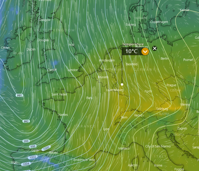
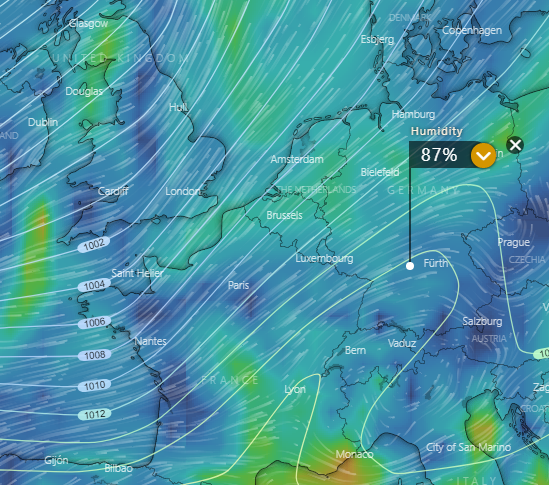
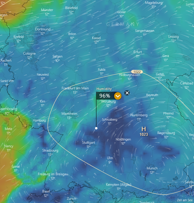
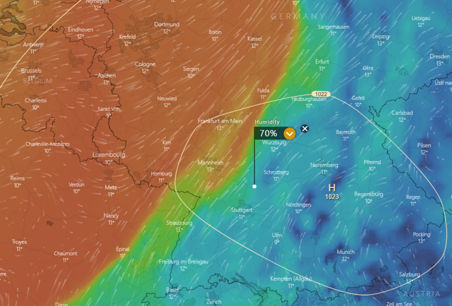
Assuming for the purpose of the discussion that the GFS model is correct, that gives you areas of zero degree temperature on the route. Checking humidity on the route, you are likely to encounter clouds over southern Germany at FL50:
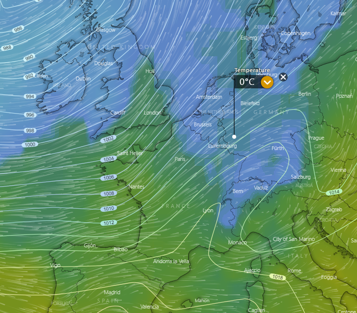
However, the good news is that FL100 is expected to be cloud free almost all the way to the destination:
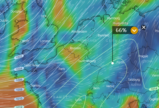
Although you might expect clouds (and possibly some light icing), lower altitudes are forecast to be above zero so you could possibly pick up some amount of ice during descent through FL50 but it would also melt below that level, which would be an acceptable risk to me.
Overall, I would be pretty confident in terms of dispatch rate over the next 10 days (barring early morning hours with possible fog at EDMA below minima).
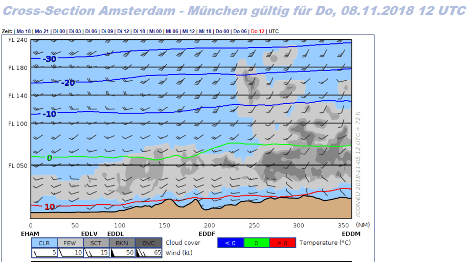
Picking yet another day (Thursday noon) where the freezing level is just above FL50, the DWD cross-sections (from the ICON model) look as follows:
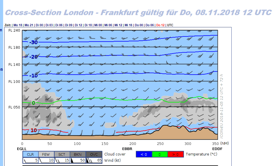

I wouldn’t see a problem flying IFR on that day and would aim for a non-oxygen level of FL90. The route is forecast to be mostly clear and I might hit some clouds (probably only light icing) near the destination but I would have “plenty of room” below the freezing level, especially with the freezing level forecast around FL75.
Hope this helps.
Also, I don’t have the MVA charts at home as they are in the aircraft but I have some slightly dated MVA chart photos which my wife took a while ago:
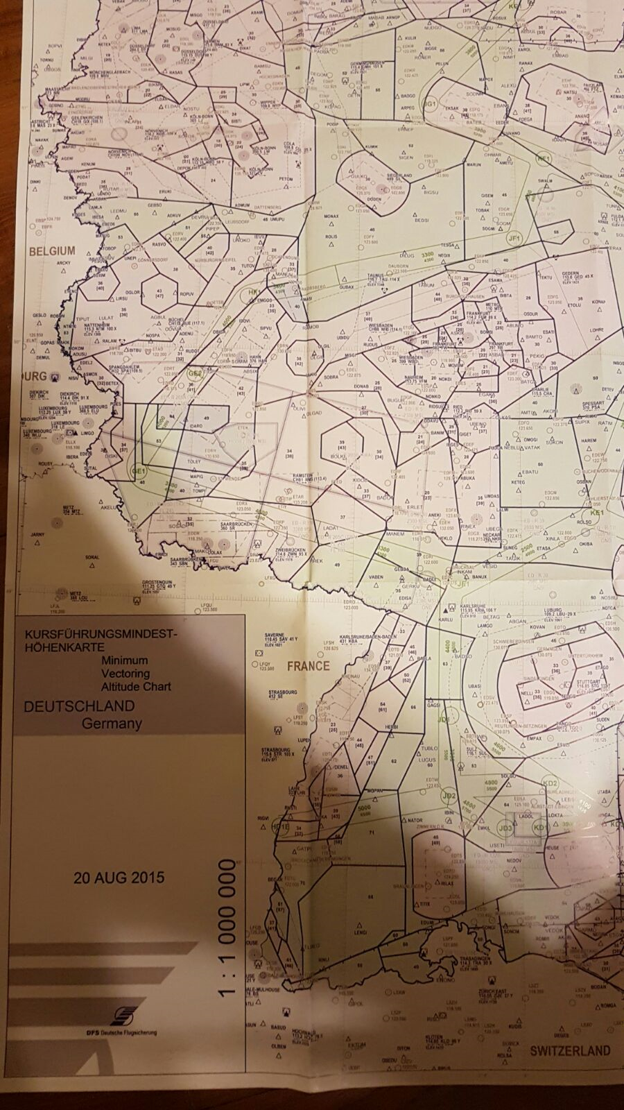
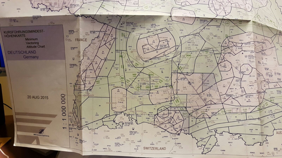
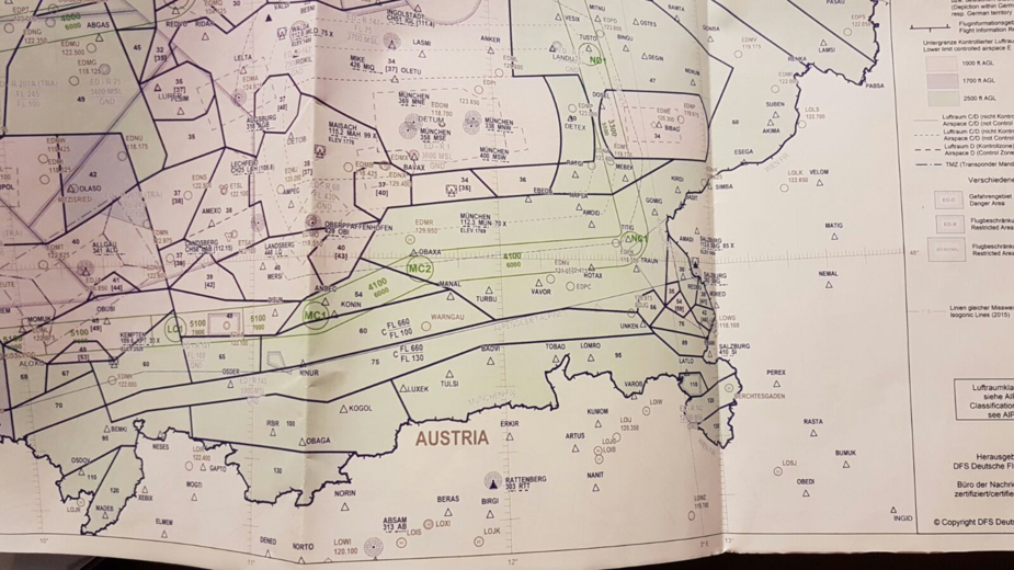
The MVAs are shown as two-digit numbers. To the extent there is a two-digit number shown in square brackets, e.g. ‘47’, this denotes the MVA during winter months (cold temperature adjustment) and would be effective now (I can’t remember the exact dates and do not have the chart legend in front of me).
Although this is a 2015 chart, the MVAs have not changed significantly as there have not been any major airspace changes for the route in question.
TimR wrote:
Comparing that with wbardorf’s method of looking at temperature, dew point and humidity on Windy would appear to show that at FL100 you get a 7c dewpoint spread at humidity levels around 60%. Methodology a lot like a SkewT just less accurate. Any cloud at that level would likely result in icing I presume.
I would not expect any clouds with a humidity level below 80%, let alone icing. Broken cloud layers would normally correspond to humidity in excess of 90-95%, which is why I normally start looking more closely whenever humidity levels are above 80%. I have yet to establish a rule of thumb about icing (and icing is obviously fiendishly difficult to forecast) so I go by the rule that icing occurs only during presence of visible moisture, which is why a humidity level below 80% should not produce any icing (as there are no clouds). I would expect icing to be possibly significant enough above 90% which leads me to avoid combinations of flying in areas of sub-zero temperatures and humidity above 90%, especially if there is no possibility of reaching positive temperatures above the MVA (for Germany and countries which do not allow IFR below MVA).
Relevant DWD cross-section and Windy examples (using ICON as model) for Thursday, 12 pm UTC:
FL 50:
FL 100:
Very important to note is obviously that we are looking at model outputs here and especially the DWD cross-section can lead to the false illusion of precision, however I have generally found them to be reasonably accurate, especially when looking at them for T+6. Of course always expect the unexpected, including an incorrect forecast, whether it be for freezing level, clouds or winds.
Normal rules for IMC, in terms of temp-dewpoint spread:
<1C means 7-8 octas cloud
1-2C means 6-7 octas cloud
2-3C means 4-5 octas cloud
3-5C means 2-4 octas cloud
>5C means clear
There is a way to translate this to RH and I believe it is strongly temperature and pressure dependent, but 80% RH will not make IMC.
@wbardorf thank you for this detailed walk-through / and the MVA screenshots. Tremendously helpful!
wbardorf wrote:
I would expect icing to be possibly significant enough above 90% which leads me to avoid combinations of flying in areas of sub-zero temperatures and humidity above 90%, especially if there is no possibility of reaching positive temperatures above the MVA (for Germany and countries which do not allow IFR below MVA).
My flight will likely be towards the end of November so freezing levels around the MVA’s can be expected. Bearing this in mind would you agree the below as a safe planning/execution strategy:
Anything else?
Yes, that pretty much sums it up for me. My level of conservatism goes up one notch if I know that I won’t be able to reach positive temperatures on the way to the ground.
I use these criteria with a non-TKS aircraft whilst with a TKS/FIKI aircraft you can presumably take slightly higher risk as long as you don’t stay in icing conditions for too long and try to get out of them (I let TKS/FIKI aircraft pilots comment…)
My level of conservatism goes up one notch if I know that I won’t be able to reach positive temperatures on the way to the ground.
Yes; you really do have to be quite careful then. Yet, that type of flying is routinely done in planes which have no de-ice capability at all; they just have to carefully make sure they remain mostly VMC, or abandon early.
Or, they have to make sure it is cold enough; I recall one departure from Dortmund, winter, -6C on the ground and about -15C by the time I reached the cloudbase. No ice at all was found then (I had prop TKS). On the descent into Shoreham, -13C initially and about -3C on the ground, I picked up about 1cm of ice, but I was going to be landing anyway. The problem there is if you don’t get to land (e.g. a blocked runway, or ATC give you a hold in IMC at -5C, etc).