
If we would be able to come up with some criteria for icing risks like above, I could consider making a dynamic chart that shows the potential icing risk areas with some disclaimer that this is no guarantee for finding no ice in other areas. Would would we have to include in the formula?
GRAMET is by far the best product out there in my opinion, have a look at their algorithms.
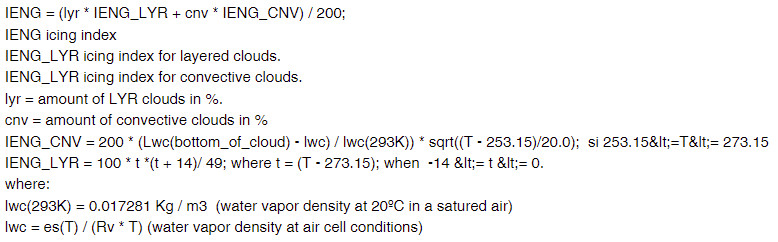
Icing Zones with moderate or severe icing are plotted. The algorithm to obtain an icing estimator developed by author is:
https://peter-ftp.co.uk/screenshots/202206143714213921.jpg
A result between 30 and 80 is considered as moderate, over 80 as severe icing.
achimha: that looks interesting!
I do not know their formula for it, but it should be a combination of: (a) where is the freezing level, (b) are the clouds of the convective type and (c) how much moisture is in the air and maybe some more.
I agree, but the fact remains that by far my worst ice encounter was in smooth stratus cloud, base 1500ft, tops 4000ft, blue skies above, nothing on the charts. ~ 30mm of ice in 5-10 mins. Max power was just OK to fly, in a slow descent. A PA28 (e.g.) would have gone down quick.
So..... what is needed is a forecast of SLD presence in a given air mass. I just don't see this exists.
The Gramet site is great for general use but it doesn't forecast a thin cloud layer, like the above example, or thinner. I have verified that on numerous flights. It just shows a blue sky all the way up.
Tom,
are you based in ZRH? If so, do I know you?
can you tell me why the guys doing the LSZH TAFs every now and then completely mess up their forecast? About 3 weeks ago during the passage of a front, both GFS as well as the DWD (EDNY TAF) correctly predicted the cloud base to drop from ~6500' down to ~1000' at around noon, in the case of GFS even days in advance. Yet it took the LSZH TAF until about 10o'clock to "predict" that drop too.
If you feel a TAF is wrong, then say so and give feedback. It can happen, should not but can. We are humans. But we need to know. Often enough in the analysis the reasons why a forecaster (of which I am not one) decided as he did are perfectly straightforward, other times they are not. But they need to know. I don't know the case so I can't tell you my take on it.
But what worries me even more is that they sometimes get the METAR's wrong too. How you can classify a solid cloud layer extending over thousands of square miles with no vertical movement as "BKN" is beyond me, and I found the explanations by Daniel Buck quite weak.
Daniel is one of the people I do listen to. I don't know what he said, but I am one of the people doing these METAR's and I consider him one of the best. If you say it was WRONG, then that is something I have to take very seriously.
BKN means 5-7/8ts of a measured ceiling. OVC means 8/8. That is, a solid, stratiform layer which has no vertical deviations we can see or measure. And that, Tom, is very rare. Basically, it does happen with stratus clouds but not much in any other condition.
We have a number of ceilometers at or around the airport which measure the exact height of the cloud base. Furthermore, I am limited to 3 layers of cloud I can give in a METAR, which have to be in an ascending order in terms of quantity, unless I have TCU or CB's in which case I can give 4 layers. So in order to get a OVC layer, I would need a cloud base where all my measuring devices show the ceiling to be on the same level. If I have measurements where there is a clear indication that there are holes in this layer, that is that the sensors give me higher cloud layers above the layer I would consider OVC possibly even if I only had my eyes to check it, then that layer becomes BKN. If I can define the layer above the BKN one, I can add another BKN (e.g. BKN010 BKN020) but I need to know if that layer is a) there and b) it's quantity. If I do not, I need to give what I can see and prove.
BKN can be anything from "more than half" to a factual overcast especcially if there are layers on top of the BKN layer, which will complete the overcast in terms at there are no "blue spots" to be seen but which does not mean the layer itself is overcast. That is why any ceiling with BKN is considered to be a main ceiling whereas SCT or FEW are not. The moment that you get BKN, you have a ceiling you might as well consider to be for all practical purposes overcast.
Clearly, the old way of indicating in 1/8ths was more exact here. But unfortunately, that is gone.
In my experience, real measurable overcast is rare and as I said limited to stratus cloud. Most of the time, there are gaps in those layers and the moment there are any, it is no loger an OVC layer. Maybe this has changed also in the way that measurements are now available which in the older days were not. It is fairly easy to declare a layer of cloud "overcast" with your bare eyes, but with the modern means you have today, it becomes pretty obvious that things are often not what you think they are :)
That hasn't been my experience. We used to call the briefing hotline of Meteoschweiz whenever we were unsure about the weather. We either got confirmation that the weather development was uncertain, or got outright wrong advice. One day we called and asked about the possibility of fog the next morning, the meteorologist was very sure that there was no possibility of fog development, yet we ended up with the Mittelland covered in the thickest fog I've ever seen which lasted for almost a week.
Again, this is something which needs to be reported and received feedback on. When it happens and not years later. It can happen that one is wrong. There are reasons why. It has happened to me, it has happened to others. e.g. that all models tell you there will be 10 kts wind the next day and then nothing happens and consequently you have fog where all indicators told you you won't have it. That is unfortunately the daily life of a meteorologist.
I can tell you honestly that this was and is one of the ongoing frustrations I had with this job after transferring from flight dispatch. It took a while to reckognize the fact that there are many situations where weather parameters are either unpredictable or at least unpredictable to the degree of accuracy and time span people expect today. In that regard, I agree, machine made charts and forecasts are "easier", because a machine does not hesitate but simply spits out it's results. The models CAN be and often ARE massively wrong however. And you need to know the weaknesses.
I can even imagine that GFS might have occasional better results long term than the much more exact models we use for local forecasting. Why? It ignores a lot of factors the local models do have but which can, in certain situations, distort the image. We had this happen this spring, when we did have a situation over weeks which was not one seen often. The models get corrected after verifications, so if you end up with something which has not happened in this way for 30 years or so, there is a good chance the model will screw it up. GFS, which in this case gave simply RAIN for weeks on end, was right of course. Our model was trying to be more precise, so it did give periods without rain, which did occurr but not always at the exact TIME it did predict it. GFS took 3 hours measurements and found oh, every 3 hours I can see the chance of precipitation being more than 80% so there you go. The European models and local models do try to be more exact and to work these 20% where there is no rain. Often enough they are right, sometimes they are wrong. Of course, this works backwards too. GFS sometimes predicts long periods of something when often enough it is just a spike.
The other thing which frustrates the hell out of me at times is that people today have totally unrealistic expectations on the accuracy of forecasts. If I get calls 3 days before in an unstable situation which demand of me a prediction whether at 10:45 it will rain or not in a situation other than a stable high pressure area, there is no serious way to tell them that. It may, it may not. Often enough people have wishes and expectations for a particular day and you have to tell them that it is not possible to predict it with any degree of accuracy. So what then? They get disgruntled and walk away instead of taking the prediction on board that the situation IS indeed UNCLEAR. That, Tom, is as much a forecast as "it will rain at 10:34, stop at 10:45 and restart at 11:15" which often is what people expect. Yes, some weather apps do this. But I think it is highly dangerous to rely on stuff like that. The automated apps and other internet ressources often enough give a totally false sense of security, either way.
If I have a major flight in front of me and I get the consensus of my colleagues that it is unclear, then I take this as seriously as a clear yes or no. If it is like that, then if the flight I want to make is ESSENTIAL, I will go on the airline. If it isn't, I am aware that I probably can't do it.
So we've given up calling the expensive hotline, because it never added anything we didn't already know from studying the weather ourselves.
Well, if that is your conclusion, so be it. I am extremely wary today of the fact that there are apps and other things out there which claim to be soooo exact and in the end are not. But it is really so as I was told when I started this job by one of the real cracks in this professions: Start to work here and nobody will ever take you seriously, everyone will remember each and every bad prognosis but none of those which were spot on.
He was very right.
If you are in ZRH and you would like to see once what it is we do, give me a shout. I'll be happy to show you around the station if conditions allow it.
Best regards Urs
Urs,
are you based in ZRH?
No; otherwise I'd have used their ILS straight away instead of searching 30mins for that hole that was supposed to be there 8-)
If so, do I know you?
No we don't know each other (yet)
If you feel a TAF is wrong, then say so and give feedback.
To whom? I posted the METAR example on your facebook page, I'd actually have liked to know how you got at that classification, but I think anyone was all that interested... I'd have liked to know why exactly this layer got classified as BKN. The "thread" is still there, April 22 this year.
April 22 this year there was basically just one layer, extending from ~3000ft to 6200ft (AMSL). It has been raining, so the bottom wasn't that well defined, with "fluff" hanging down a few hunderd ft. Maybe that made you think it was two layers. The top was really flat, I flew over it for 1.5 hours (my aircraft may be slow but not that slow), half an hour just a few hunderd feet above it, there has been not a single hole in it.
When I flew through it (on the ILS14), there was no turbulence, as one would expect in a BKN layer.
They get disgruntled and walk away instead of taking the prediction on board that the situation IS indeed UNCLEAR.
Well yes. We all know that Meteorology is not an exact science. But your claim was that only a professional meteorologist would understand weather model output. Three people now posted saying in effect that asking a professional meteorologist didn't add anything material to their view of the weather. Yes it's not "fair" in the sense that a pilot would only call the weather briefing hotline if the situation was sufficiently difficult, but that's the only thing that is relevant to us pilots. If we get value added information in exchange for the time and money spent for the call, we'll call. The consensus seems to indicate otherwise. I bet the hotline is not used very often, but maybe you have the actual numbers.
I take this as seriously as a clear yes or no.
I take that seriously too. However, if I knew this already before calling, this is not adding any information, therefore I will not call in the future. If the call didn't make the uncertainty less, it didn't add any value, therefore it didn't justify the expense in time and money.
Yes GFS may be crude, but it beats all other models in terms of availability. Look at the ecosystem created by GFS, be it Ogimet, the AeroPlus Weather app, even I use its output for my flight planning software. Therefore, GFS is a lot more useful than any of the european models because many of the applications possible with the GFS data would not be viable at the access fees european weather services ask for their data.
Weather forecasting is a service. That service is used by people if they find it useful. Instead of wishing the "good" old times back when users just trusted their professional meteorologists and didn't dare to try to picture the weather themselves is not going to be productive. These times are not going to come back.
We live in a networked digital world. 45.45 Baud Telex is no longer state of the art. One can do better than METAR and TAF. When asked why this cloud layer was classified BKN when OVC might have been the more useful classification, Daniel Buck basically said that they couldn't do better because that's how the coding rules were. How about some innovation? How about making ones products more useful for ones users? For example, if it was so difficult to classify a cloud layer, why not offer the raw ceilometer values as well? (remember the data processing lemma: data processing can never increase the information content, only decrease it). If a weather situation was hard to predict, why not add some metric on the predictability of the data elements? Meteoblue is doing this right now. The DWD has been introducing new products on the flugwetter.de site recently. Yet on meteoschweiz.ch, I don't see much innovation happening. The aviation offering is, um, quite pathetic.
If you are in ZRH and you would like to see once what it is we do, give me a shout. I'll be happy to show you around the station if conditions allow it.
Now that's an offer I'd gladly take. How many people could you accomodate? I'm sure I can find quite a few people interested in this.
Tom,
I don't know how to do private mail here but contact me off forum pls, so we can arrange something. You can find my mail via my website . If not, tell me and we'll find out what to do.
The "thread" is still there, April 22 this year.
Where? I went through the whole page and could not find anything. email pls?
The top was really flat, I flew over it for 1.5 hours (my aircraft may be slow but not that slow), half an hour just a few hunderd feet above it, there has been not a single hole in it.
Ah. Ok, well, BKN layer(s) in a METAR do NOT mean that there are holes in the clouds. No way. It means that the reported layers had holes, bottom to top, not the other way around. METARs only report what is visible from the ground, not what is on top. If the undercast where you were flying was closed, that does not at all mean that the lower layers were.
It has been raining, so the bottom wasn't that well defined, with "fluff" hanging down a few hunderd ft. Maybe that made you think it was two layers.
So that means probably some FEW at very low and then possibly SCT and BKN above that. Yes, that would pretty much be what I expect in such a situation. I am not at work, so I can't pull up the full picture, but it does make sense to me. And yes, that could indeed be a coding rule problem. If you run out of layers, then you can't give an overcast layer if 3 others are below it.
But your claim was that only a professional meteorologist would understand weather model output.
If that is how it came across, I did not make myself very clear. What I am saying is that these people do know more about how to interpret those models than anyone outside can. That does NOT mean that pilots don't understand what they see in the model forecasts, it just means that it is quite likely the forecaster can see more and different things. If you call up because you are unsure and so is he, that means, amongst other things, that you were right in your assessment of the situation. I've experienced this much different many times.
Therefore, GFS is a lot more useful than any of the european models because many of the applications possible with the GFS data would not be viable at the access fees european weather services ask for their data.
GFS is great mainly because it is openly available. Would Ogimet and others be able to use the European models as well, the results would be even more interesting and probably a lot preciser even than they are now. Unfortunately, it is European policy that these models are not freely available, so GFS is what everyone uses. You will understand that I do not comment this.
Instead of wishing the "good" old times back when users just trusted their professional meteorologists and didn't dare to try to picture the weather themselves is not going to be productive. These times are not going to come back.
Neither do I want them to, no way. Heck, I can see quite clearly how much all this has evolved only in the 12 years I am at it and I love most of what has evolved. But like any and all information available on the Internet, one needs to know how to use them. We all do that, we look at the GRAMETS, which btw I love, and we check out what the results are. Do we get burned flying with it? Is it good, what's wrong? If something is wrong, then you learn time after time where you can trust a product and where not. That is what our daily work includes as well. If I know that one model 90% of the time exagarates rainfall figures, I'll know this after a while and interpret it accordingly. But how do you want to interpret a product someone has done where you don't know the source nor the method? All you can do is try it and if it works for you hope, it won't burn you when it encounters something it has not been programmed for yet.
It gets dangerous if I get people who will simply look at their weather pro prediction and plan flights with it, or if they read "professional" charts available on the net without knowing what they do, or worse think they do but don't.
One can do better than METAR and TAF.
Yes, no question. Then again, you need to differentiate what each product is intended for, not try to use them for something else. A Metar or TAF have no function to report or predict (in the trend) how a cloud system looks from above for a start. They are clearly defined products to give forecasts/status reports for an airport, from ground up.
The other problem is, it is very difficult these days to get such products produced and delivered, especcially in the aviation field. If you produce something as the official weather service, it needs to be approved and certified as an aviation product. ICAO Annex 3 clearly states what may be produced and what not.
True, some met services have a larger offering in products. It is unrealistic that a relatively small organisation like us should compete with the DWD (actually we do cooperate rather than compete) or the NOAA. I agree that there is room for improvement.
Now that's an offer I'd gladly take.
Let's keep it between us for a start? We can always do something bigger at a later scale. Contact me pls and we'll see where to go from there.
Best regards Urs
I thought that OVC was simply banned from TAFs. The "worst" you got was BKN. Interesting...
A lot of stuff is simply wrong e.g. the PROB30 & PROB40 being the only options. It has led to a shorthand whereby - in the UK, anyway - PROB30 is a back-end covering exercise (which ensures no wx forecast - fog excepted - will ever be provably wrong) and PROB40 means "we think this might actually happen".
The national European wx services don't open their models because they sell the data to commercial weather repackagers. For example if you are a big DIY chain and you want to know whether on the coming weekend to do a special offer on decorating gear (crap wx) or a special offer on gardening gear (good wx) you pay some considerable money to a commercial wx repackager service which will give you a "customised" forecast.
Whether the national models are better than GFS has often been debated. I heard that the UKMO model is better in the traditional SW flow conditions which the UK sees most of the time, but not so good in all the other ones. I've not seen any evidence suggesting the UKMO model might be better than GFS for aviation-type 3D forecasts; I've spoken to forecasters who were paying £ 4 figures / year for access to 3D data and it didn't seem it was any better than GFS. In fact I know some of them use GFS for some of their stuff, to save money.
Whether the national models are better than GFS has often been debated.
They have one major advantage: significantly higher resolution.
We all do that, we look at the GRAMETS, which btw I love, and we check out what the results are [...] But how do you want to interpret a product someone has done where you don't know the source nor the method? All you can do is try it and if it works for you hope, it won't burn you when it encounters something it has not been programmed for yet.
Because the GRAMET guy is a hobbyist whereas the others are pros? Like Linux is from hobbyists and Windows from the pros? Sorry, this is a market where users make their own choice and GRAMET is a real game changer. For the first time, someone has actually spent some thought on sensible chart representation. I know that the DWD people are very impressed by it and feel the heat. All they do is offer a pre-computed chart of a few dozen routes in an inferior representation and I don't want to know how much budget they spent on that.
I hope for the following:
Until that happens, we'll be stuck with GFS. Not that it is bad but it's sad to see all that European tax money being used for something that is not accessible.
Achim,
Because the GRAMET guy is a hobbyist whereas the others are pros?
No, not because of that. GRAMET is great. Not only the DWD people are impressed with it, everyone I've talked to is. You are right, it is currently the best representation for pilots. And obviously it has to use GFS for the very reasons you state.
the national weather services get merged into a European weather service. One model, best of breed instead of 25 semi good models
This one would have possibilities but is not going to happen in a hurry. What I do see is increasing cooperation between the services, such as the D-A-CH group. But like in other such aspects, Europe is not by far as "united" as it sais on paper, nationalist sentiment will prevent several countries to unite their services with others.
there is free of charge open access to the data, maybe commercial users continue to get charged for it
There are movements in this direction. Whether it will come true to that extent remains open. It would be nice however if the services start to develop their product lines according to the needs of the core groups.
DWD has one of the best weather platforms I think with "flugwetter.de" respectively PC Met. They also were the first to include meteograms like Gramet now does, however, as you say, Gramet takes it to a new level. Europe is however still and on purpose a long way behind what NOAA offers.
My concern with the GFS model is not so much it's quality, it is pretty good for what it is used. However, under Obama the US have moved towards the European model, so it could well be that GFS from one moment to the next is no longer freely available. That, as I hear, is a MAJOR concern with a LOT of people in recent years. We do see a lot of US ressources disappear in recent years, not least the Sembach site, which is now no longer available to the public. If that happens, a lot of people in and outside aviation will have a MASSIVE problem on their hands.
I would argue the Sembach site did not offer any value, by the time it finished. There are countless "graphics from GFS" sites.
If GFS access ends, it will be left to somebody to set up a consortium to throw some money at say the UKMO and use their model. And obviously charge an annual subscription, or maybe run an advertising-based site (like Meteox). Does the UKMO charge more according to how many people can access the final product?
What other US data has disappeared? There was DAFIF in 2005, but that's because the national CAAs around the world shafted the USA by threatening to withdraw aeronautical data unless the US stopped publishing it openly. GFS data doesn't come from €€€€€urope.


