If you’re gonna try to cheat the system, he should have just left VFR, gone to 17500ft and once well away asked an under-worked center controller for a popup.
I admire the tranquility of PIC in following ridiculous ATC requests and replying in decent and professional manner.
This looks like at least 2 airproxes were triggered by this totally inadequate behaviour. I suppose there must be an investigation going on in the US about this.
I’ve not yet listened to the recording, but unless you hear “possible pilot deviation” from the ATCO there will be no investigation. The US doesn’t have an airprox board.
He gave a traffic alert repeatedly and they were VERY close to at least two airliners at some stage.
In Europe, this would be a MAJOR investigation. I can not believe that something like this goes through in the US without any consequences.
Mooney_Driver wrote:
He gave a traffic alert repeatedly
That’s their job, separate IFR from VFR, and with VFR you have to get a positive vis. This seems pretty normal to me, if it wasn’t for the fact that the aircraft was a big jet on a IFR mission across the globe, and the total confusion about what mission he actually was doing. (I have to listen again though, did it last night with only half an ear).
AdamFrisch wrote:
If you’re gonna try to cheat the system, he should have just left VFR, gone to 17500ft and once well away asked an under-worked center controller for a popup.
I would have expected something like that
Emir wrote:
I admire the tranquility of PIC in following ridiculous ATC requests and replying in decent and professional manner.
I admire the controller for his restraint
First, the jet did not depart IFR. A VFR departure in the US is not connected with an IFR flight plan as is the case with a YFR. YFR is not supported in US airspace. So the jet departed VFR and was assigned a right hand pattern at 1500 feet. The pilot should have indicated the direction of flight requested for VFR and the desired VFR altitude in communications with the tower before departure. The highest VFR altitude over BFI to the south is 1100 and to the north at 1800. To the east or west,it is 2000. To go higher, the jet would need a clearance into or thru the Seattle class B where he could be assigned a higher VFR altitude. The pilot never requested a climb thru the B nor did he receive a VFR clearance thru the B. If he had departed IFR, the IFR clearance covers any operational altitude or route assigned by ATC.
So I would have requested a clearance along the intended direction of flight via a climb thru the B. So my request would be something like, request VFR climb thru the class B to 17500 on an easterly route. That would have resulted in vectors from the tower with an eventual VFR clearance thru the B and to contact Seattle Departure. then once on the Seattle departure frequency, I would request to pickup my IFR clearance from KBFI to LGAV. Something like: “Seattle departure, big jet de[arted KBFI, would like to pickup my IFR clearance to LGAV Athens.” This would only be possible if the climb could be conducted in VMC.
When departing VFR, a tower has no clue where the aircraft is intending to go unless verbally communicated with the tower. So an on course heading and altitude should be requested.
Emir wrote:
I admire the tranquility of PIC in following ridiculous ATC requests and replying in decent and professional manner.
The tower was extremely professional in my opinion. The jet pilot was not, primarily in that they did not understand the VFR limitations and the class B and who controlled what. By not requesting an appropriate VFR departure to an altitude and heading thru the class B, the tower was unable to read the pilot’s mind and was constrained by keeping the aircraft out of the class B and in VFR airspace that he controlled. The only thing the controller could have done was to pin down the jet pilot’s intentions before the departure. The departure was not operating under any active flight plan, VFR or IFR. They were expecting to be able to pick up an IFR after departure and on the tower frequency. If the pilot climbed into B airspace without a clearance into the B, it would have caused a pilot deviation.
For pilots that have filed an IFR flight plan and that intend to depart VFR and pick up the IFR clearance after they are airborne, they need to understand the system. The IFR will remain in the center computer for 2 hours past the scheduled departure time. Only that center or the departure TRACON will be able to locate a flight plan filed within that center. Other centers along the route will not have a clue until the flight plan clearance is issued by the original center or TRACON, who will then coordinate with adjacent centers and FIR. So, particularly if departs near a center/FIR boundary, they need to contact the original center for their clearance or they will be told that the flight plan is not in their system. This can result in the aircraft needing to contact FSS and file a new flight plan from a nearby point and then go back to the new center to get the clearance. If ATC is too busy, they are not required to issue a clearance to an airborne aircraft and may tell the pilot to contact FSS and pickup their clearance.
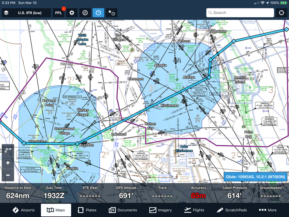
One final note, each airport is assigned a center that flight plans are route to. Each airport in the US NAS has the center included in NASR database, so filing systems look this information up. Near center boundaries (+/- 50 NM), the charted center boundary is not used, but an uncharted surface center boundary is used. Here is a screen shot of a difference where the surface center boundary does not match the charted one. All the centers have agreements on where the surface boundary is located and in almost any boundary, they are different. The blue line is the charted center boundary between Miami Center and Jacksonville Center. The magenta line is the surface boundary and is where the flight plans get routed to.