Peter wrote:
If the crash site is in the main canyon, I would bet he was in IMC at the time.
And that would be even more worrysome. IMC at 6k in the Alps with huge peaks all around following the valley?
Obviously we do not know but it would appear according to the reports in this thread that it was CAVOK. Certainly the photograph of the crashed aeroplane indicates reasonable weather and viz.
As was already said at the start of the thread, even with unlimited visibility the Simplon pass is different to many other passes. When approaching – even with a 1’500ft margin over the pass – you basically fly through a curved canyon and cannot see through to the southern exit of the pass.
“You can never outclimb the terrain” is one of the important rules for clearing passes. Since the pass is very close to the Rhône valley it is safe to have reached already the recommended altitude of 8300ft when leaving the Rhône valley at Brig to Simplon pass.
BeechBaby wrote:
Obviously we do not know but it would appear according to the reports in this thread that it was CAVOK.
As LeSving has already hinted, CAVOK is not generally a useful concept in mountainous terrain. CAVOK refers to the conditions at a specific airport and particularly in mountains conditions can change rapidly over short distances. Also, CAVOK does not mean that the sky is clear – not even at the airport.
Airborne_Again wrote:
As LeSving has already hinted, CAVOK is not generally a useful concept in mountainous terrain. CAVOK refers to the conditions at a specific airport and particularly in mountains conditions can change rapidly over short distances. Also, CAVOK does not mean that the sky is clear – not even at the airport.
I fully understand that. I was referring to the suggestion that he may have been IMC and merely questioning why someone would fly IMC at 6k with MSA of 8300?
It would be suicide.
Understood. 2 days ago, I flew around Barcelonette on the morning (9am), and it was cavok on the whole south east of France, convective 50nm at the north but ok there. The evening before was very convective and there have been rain showers in some of the valley. Although over the mountains it was bright sun, some valleys were totally foggy resulting from residing moisture of the evening before, and some still there at 11am. If you fly low on the mountain following a valley, you can encounter such fog while turning in a valley like showed by the FR24 trace and have to decide rapidly to U turn.

It is still suicide to fly that low, and this is the first problem.
Another exemple of tricky cavok is the one that kills the JU52 last year. cavok but damn hot and strong winds, but we already established it wasn’t the case.
CAVOK is no cloud 5000ft AAL, or MSA, whichever is the higher.
In these canyons, the MSA is way above the aerodrome elevation, or 5000ft.
Similarly the METAR reporting goes that much higher, in these areas.
But this was not near an airport (within the CAVOK reporting radius).
Can anyone post a google maps pic showing which canyon a pilot would have properly turned into? On a quick look, none of the ones near this pilot’s southerly turn go anywhere useful.
Peter wrote:
CAVOK is no cloud 5000ft AAL, or MSA, whichever is the higher.In these canyons, the MSA is way above the aerodrome elevation, or 5000ft.
Similarly the METAR reporting goes that much higher, in these areas.
But this was not near an airport (within the CAVOK reporting radius).
Can anyone post a google maps pic showing which canyon a pilot would have properly turned into? On a quick look, none of the ones near this pilot’s southerly turn go anywhere useful.
Peter, CAVOK is also used by pilots to mean no cloud good visibility anywhere.
To me that whole thing sounds a little big like pilot incapacitation. The FR24 track (FWIW) shows a level flight, way too low, straight into the cumulus granitus. I have a hard time imagining anyone who has his wits about him to fly like that. I also disagree that a PA28T doesn’t climb above 6k ft, this is a ridiculous assertion. I learned to fly on PA 28/160s and/180s and they happily crossed the mountains surrounding the L.A. basin (6-11 k ft) on warm/hot days. They certainly aren’t the best climbers in the world, but the guy had 60NM to get to altitude.
Hello,
I fly Robin DR40 in Sion (LSGS) and live near Sion.
The weather was good, a bit of mist but light ! It was VMC
The METAR of LSGS was VRB02KT 9999 FEW080 20/14
It was a bit warm with a high DA but the Simplon Pass is the lowest pass in the Alps. When taking off from Laussane any plane is able to climb to 8’000ft. Our Robin climbs without problem to the Matterhorn at 14’000ft
I attach the image of a webcam located in front of the pass, at the time of the accident
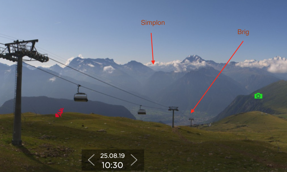
Well if that is a bank of mist forming a layer along the valley, and he flew into that at 6k, charging along at 150kts, with tops clear then that would be a monumental error of judgement. And yet that is what FR24 shows. Pretty strange unless he feared being trapped on top with no VFR ref? In that case he should have turned back or an immediate climb to MSA