It’s fast change in air pressure that affects ears. Babies going slowly to higher or lower pressure altitude would not be affected, e.g. being carried up/down by human on foot. Or SLOWLY in a vehicle.
A very gentle climb and descent in an aircraft would be better than a fast climb and descent to minimise time at altitude.
Normally a climb is not a problem because the eustachian tubes readily open in that direction. It is when descending that you get a problem. Are babies different in that respect?
Normally may be, but I can say I have seen various behavior. My son (8yo) handles 800fpm descend with some pain, 1000 and he shout for stopping.
I have transported some younger (3 and 5yo) one to cure for whopping cough, and they supports a fast descent at 1500fpm without problem but shout when climbing at 600fpm…
every airliner is worse than that. My babies were having a very bad time whenever we were travelling. Giving them something to drink can help.
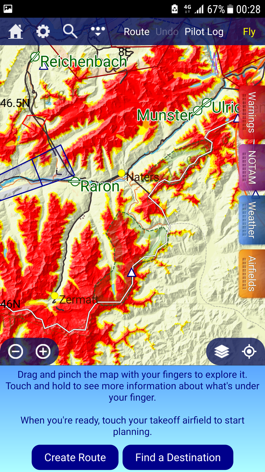
SkyDemon shows a ‘route’ through a pass (GAFOR) assuming the feature is ‘on’ and not stopped displaying it (see ????’s about this earlier in thread).
Assuming a ‘gin clear’ day, unless one is very knowledgeable about a particular route, it still can’t be easy to ‘map read’ your way through a twisty pass even if a knowledgeable person has drawn the required ‘pass route’ on your chart before departure. So for a novice (for want of a better word) having that SD GAFOR route on display would be a huge aid and a great comfort. Not to mention if using SD you can ‘click’ your way along the GAFOF at the planning stage. This produces a lot of waypoint (close together) but that is of no real problem.
What other moving map device can ‘paint in’ a GAFOR pass like that? SD can’t be the only on.
I certainly would not want to attack the twisty Simplon (no pressurisation / turbo / Ox etc.) without the pass route showing on my moving map – whatever device. Without the ‘pass route’ on a moving map, a brief reduction in viz would be very unnerving for the ‘novice’.

WarleyAir wrote:
Assuming a ‘gin clear’ day, unless one is very knowledgeable about a particular route, it still can’t be easy to ‘map read’ your way through a twisty pass even if a knowledgeable person has drawn the required ‘pass route’ on your chart before departure
I see you have +20 points in the route, that is a lot to keep track of 
Low level VFR navigation skills are less to do with with ‘novice’ either you a local guy or you are not
Over navigating moving maps at low levels make it even worse even with a planned route plotted, you get load of illusions from screen zoom +/-, so best to keep a simpler route of 3 heading/distance/times loaded in the back of your mind in case
If you fly +3000ft higher on a ‘gin clear day’ you should see +10km full way through that pass with max 2 or 3 ref points at the time?
Why do you have to ‘keep track’ of all the waypoints. They produce a curvey magenta line which can be flown like any other magenta line.
Stops you turning into the wrong valley – must be a valuable aid in VFR.
Yes but following that curvy magenta line at the wrong altitude does not save you from planning errors: as your altitude goes lower you will need more points in the magenta line, when the curve gets more complex you risk turning in the wrong valleys (this depends on your altitude)
Actually, turning SD terrain colors ON with “reference red color” being pass altitude, +1000ft, +2000ft, +3000ft does clearly show the “wrong valleys” and how many are there, so gives better terrain appreciation and simpler routes to follow, these could be easy to navigate if SD goes off than the +20points route you are plotting…
I think you can plan a simpler route at 8500ft without much worry about the 5 wrong valleys?
Simplon pass is your only choice of any route until 10500ft
Here is at 6500ft
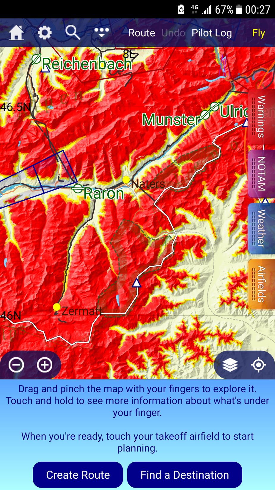
Here is at 8500ft