As indicated before, those GAFOR routes appeal to more functionality in SD than foreseen:
1. Route definition over the ground (a bit like VFR routes)
2. Weather forecast
3. Altitude indication
In SD function 3 is underdeveloped and it would be a safety enhancement if SD would indicate the Minimum Crossing Altitude as in the swiss charts.
So in reality: GAFOR is more than weather forecast in SD: it is also a VFR route indication
LeSving wrote:
Then what has this to do with roads?
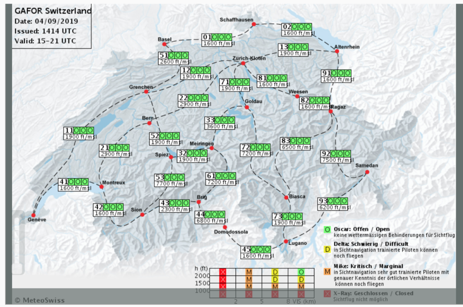
Nothing. But in Switzerland and Austria they are route forecasts. In other countries that doesn’t have alpine terrain, GAFOR forecasts are usually area forecasts.
Are these “routes”, or whatever it is, called GAFOR in Switzerland also, or is this something SD has “figured out” ?
Yes they are. The information is taken straight from the AIP. Why should they be something SD has “figured out” as you call it? Why the condescending tone?
It is rather obvious that some people are putting more into these “routes” than what is the intention. I’m just trying to figure out what they are, and what they are not. Are they routes (in the VFR flying sense of the word), or not. For instance. From what I gather in this thread, they are NOT. They are simply weather forecast, and has little to do with VFR routes (like those VFR routes on maps of TMA/CTRs).
@LeSving, in Austria and Switzerland, these GAFORs are wx forecast for a series of valleys and passes that can be used as a VFR route to cross the Alps. I think this has been mentioned several times here already. You can fly anywhere you like, but the GAFOR helps with decision making.
Again, this has nothing to do with this accident where a pilot flew straight into a mountain on a clear day with no / almost no wind.
Airborne_Again wrote:
Then what has this to do with roads?
Nothing. But in Switzerland and Austria they are route forecasts. In other countries that doesn’t have alpine terrain, GAFOR forecasts are usually area forecasts. Are these “routes”, or whatever it is, called GAFOR in Switzerland also, or is this something SD has “figured out” ?Yes they are. The information is taken straight from the AIP. Why should they be something SD has “figured out” as you call it? Why the condescending tone?
In my opinion, VFR routes do not exist
For example Brig – Meiringen can be closed but the flight quite possible by the Aletsch Glacie and the Jungfrau.
Brig – Domodosola can be closed (at the altitude of the road) but the flight quite possible “on the top” by passing anywhere up to 14’000ft
Open does not mean easy no danger …
It indicates only the height, relative to the ground, of the expected cloud layer, at different places
Obviously, nobody should fly into a mountain in VMC.
But still lots of people do it. Even locals do it.
Usually multiple holes in the cheese need to line up for it to happen.
In this case there must be a clear explanation for the leisurely climb to 6000ft, and it must be that the pilot thought this will be sufficient. He wasn’t somebody stupid. No way could he have been thinking that the baby will come to harm at say 7000ft or 8000ft. Just like I am sure D-ESPJ saw the “6500” and descended down to it (though he was prob100 in IMC, either the whole time at/near 6500ft, or later). Very clever pilot; I knew him well.
So I reckon he saw a figure somewhere… On some map. That’s the first hole in the cheese.
Then as he turned south to enter the canyon, he didn’t realise fast enough that something looks really wrong. The Alps are HUGE and it is hard to judge whether something is 1000ft below you, or 500ft, or 5000ft, unless you have familiarity with it. That’s the second hole in the cheese.
LeSving wrote:
Are they routes (in the VFR flying sense of the word), or not.
They are not routes in the sense of ATS routes. But they are certainly routes in the sense that they are particular paths over the ground which are reasonable for aircraft to follow.
Are there any anemometer records for the Simplon Pass for the morning of 25 Aug? Or an estimate of the highest wind speed within the surface boundary layer there?
Qalupalik wrote:
Are there any anemometer records for the Simplon Pass for the morning of 25 Aug? Or an estimate of the highest wind speed within the surface boundary layer there?
There was almost no wind that day
There was very little wind on the day we came through (or I wouldn’t have attempted it)
We did have a 2-300ft/min sink, at one point in the actual pass.