there is no problem of visibility in these conditions.
the webcam if on it is 20 kilometers from the pass and more than 7km from Brig
CAVOK is no cloud 5000ft AAL, or MSA, whichever is the higher.
When I was briefing Samedan, I saw that they had their own definition of CAVOK (essentially, good enough for a safe visual approach) but I can’t now remember what the definition was.
Timothy wrote:
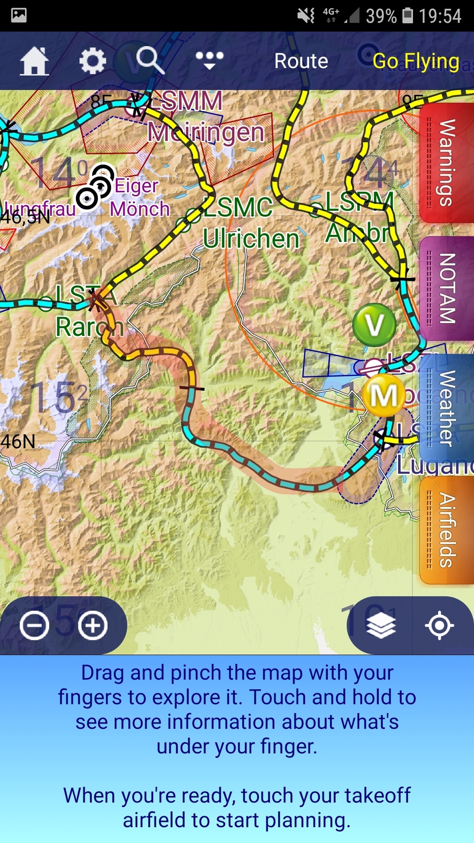
and carefully marked up every twist and turn in SkyDemon.
While this is a very good planning exercise and should help increase your situational awareness, there is no substitute for real-world looking out of the window when mountain flying.
This is the opposite of IFR where you need to disregard your impressions and go with the instruments.
If your careful plan is not looking good out of the window, surely you would climb further or turn around or something before it is too late?
We have all made mistakes in planning, have we not?
Thanks for your great post, Gigicret, and welcome to EuroGA. What options does this leave us with?
I am 99% sure I know the pilot, though not personally. PPL+IMCR, with a fair bit of European touring time, but prob99 no oxygen, and with a small child on board not likely wanting to go too high. Posted here a lot, too. I don’t want to post more until confirmed, because due to the long weekend (today, Monday, is a holiday in the UK) it’s going to take the local police extra time to track down his family (not that anybody of his immediate family is alive now).
Pilot incapacitation, with his wife sitting in the back seat with the child (as is often done)?
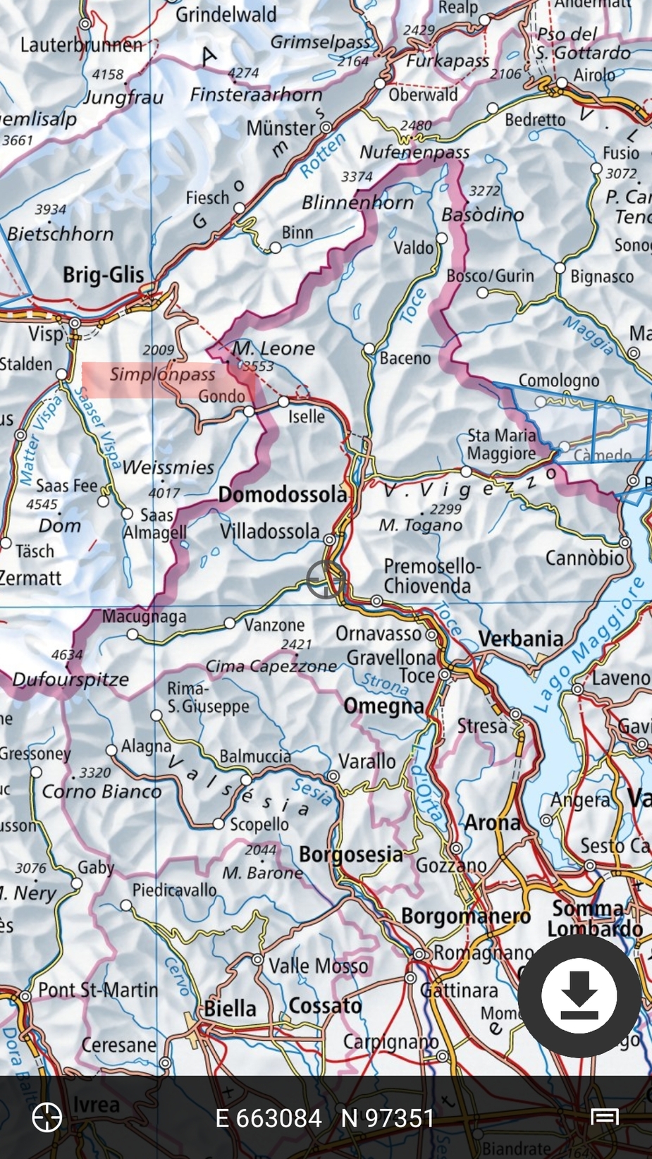
That final southerly turn is not clear to me. As I posted above: Can anyone post a google maps pic showing which canyon a pilot would have properly turned into? On a quick look, none of the ones near this pilot’s southerly turn go anywhere useful.
showing which canyon a pilot would have properly turned into? On a quick look, none of the ones near this pilot’s southerly turn go anywhere useful.
Not sure if I misunderstood you, but actually it is the GAFOR-route 44, heading from the Simplonpass south and then east towards Lugano?
I have uploaded some screenshots showing the route.
BTW, although maybe not the place to promote nice Apps, but there is an App “Swiss Map” where one can nicely zoom into each detail of the Swiss maps (units shown are metric).


Peter wrote:
Thanks for your great post, Gigicret, and welcome to EuroGA. What options does this leave us with?I am 99% sure I know the pilot, though not personally. PPL+IMCR, with a fair bit of European touring time, but prob99 no oxygen, and with a small child on board not likely wanting to go too high. Posted here a lot, too. I don’t want to post more until confirmed, because due to the long weekend (today, Monday, is a holiday in the UK) it’s going to take the local police extra time to track down his family (not that anybody of his immediate family is alive now).
Pilot incapacitation, with his wife sitting in the back seat with the child (as is often done)?
That final southerly turn is not clear to me. As I posted above: Can anyone post a google maps pic showing which canyon a pilot would have properly turned into? On a quick look, none of the ones near this pilot’s southerly turn go anywhere useful.
The pilot is the owner of the Piper
The newspaper lematin.ch publishes a blurry picture …
The accident did not occur where the flight radar road stops, the accident occurred approximately here
Timothy wrote:
CAVOK is no cloud 5000ft AAL, or MSA, whichever is the higher.
When I was briefing Samedan, I saw that they had their own definition of CAVOK (essentially, good enough for a safe visual approach) but I can’t now remember what the definition was.
In Switzerland CAVOk means
- horizontal visibility + 10km
- no clouds below the MSA (Minimum Sector Altitude)
- no CB or TCU
- no significant meteorological phenomenon
For Sion LSGS the MSA is at 16’000ft
For Samedan LSZS 10’000ft
Forgive me GIGICRET was he supposed to turn right into the valley towards Breithorn? Did he miss it or was his route to go further up from where he impacted?
Gosh… I (have a couple hundred hours in a 1979 Arrow IV… exactly like the one that crashed) did write:
* he was fairly heavy
* it was fairly warm
* NA Piper Arrows don’t climb all too well anyways
*maybe he did not know how to adjust Vy for altitude, and maintained 90KIAS in the climb
*maybe (I have seen this many times) the pilot reduced the power to “25/25” after takeoff, and then never advanced the throttle and prop as he climbed higher.
*maybe he didn’t know about leaning
If you put all this together, an NA Arrow does not climb AT ALL above 6000 feet MSL
So, once again:
And yes, I did say that I think it would be unlikely an owner pilot would not know how to operate his aircraft.
Actually, I have had this aircraft up at 14000 feet, in summer, two up. Right in the Valais Alps btw. See here. It actually didn‘t struggle at all. But it needs technique (mixture at exactly best power, prop full forward, speed at exactly Vy corrected for altitude, ball in the centre, etc.)
If you put all this together, an NA Arrow does not climb AT ALL above 6000 feet MSL
So why did he not turn round?