Valtime wrote:
What is EAD? What does it stand for? Is it the British AIS?
EAD is the European AIS Database – a repository of AIPs, NOTAMs etc. both in human and machine-readable form kept by Eurocontrol. It has the AIP data of all EASA countries and a few others as well (such as Jordan and the Philippines).
(Some important updates made to my post #7 above.)
EAD is a repository for European AIPs. It has been up there for many years. It is behind a login for some bizzare reason, and the URLs of the PDFs change all the time to prevent people passing them on, bookmarking them, etc. That’s why each time someone here posts one of the URLs I have to download it and upload it to EuroGA  But it is the only pan-European repository of AIP data. The only other way is to dig around each country’s national website, the above mentioned Royal Swedish Aeroclub, etc.
Some countries do not supply data to EAD, for unknown reasons.
One can imagine a foreign pilot going completely mad with the deliberately restrictive “system” Europe has. Or… spend $$$$$ on a Jeppesen package.
Peter wrote:
But it is the only pan-European repository of AIP data. The only other way is to dig around each country’s national website.
Please note that I found a few times recently that https://www.aurora.nats.co.uk/ for UK AIPs some times showed older data than EAD, sometimes just non-existent links.
I’m not sure that there is any other source really than EAD…
Peter Said:
EAD is a repository for European AIPs.
Very interesting. This would have saved me a lot of time When I was working wit foreign AIS… I’ll register and see what is available there.
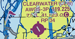
I learnt to fly with the French ‘Atlas VAC’ so am naturally biased. I think it’s having all the information you need, well laid out, in a standardised format easy to read in flight. It’s approach chart, taxi diagram and AIP entry in one concise document.
Initially I was incapable of flying to another airfield without it, but now it’s ok as long as the frequencies and runway are written down and I’ve been there before (to not get lost taxying on auto-information).
Pre-gps the VAC’s zoomed-in map was good for finding the airfield: you could find the town with a VOR and 500.000 map, but the VAC would show you (e.g.) next to the north road with a big factory at one end.
Pictorial information is much more user-friendly, e.g. circuit direction as a right-angle arrow rather than having to read through a block of text.
In France reporting points are not on the 500.000 maps, so you should really have the VAC if flying through a TMA or CTR. Less of a problem now with Skydemon etc.
I can see the attraction of having a minimum amount of information, shown on the sectional. This would never work in the UK, where entries in the private flight guides (Pooleys, AFE) seem to have been written at length by the airfields themselves.
From the first 10 pages of GEN1.1
to decipher the VAC:
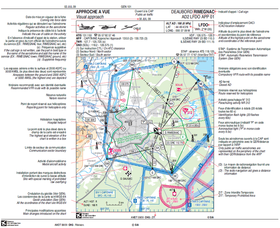

The French VAC is way more user friendly, takes to 2 seconds to read and land !
If one goes to EAD and does an Advanced search with the ICAO code, and all the other selectors left unselected, one usually gets one PDF (optionally followed by others; see below) and for some countries that PDF is what in France they call the VAC.
For France, this seems to work fairly well even for obscure small places.
I am told it can be more than one PDF in some other countries.
In the UK it is just one – even for Gatwick – and it is what is normally referred to as the “AIP” which you check for customs/immigration, opening hours, blah, blah.
Some countries reportedly don’t deliver anything to EAD; not exactly sure what they are. In Germany, it appears, you get nothing at all from EAD unless the airport has instrument approaches and then you get the AIP and all the charts

The UK does the same but you get the AIP for VFR places too (not all, which is why people buy e.g. the Pooley’s Guide)

By using the AIP Type selector and selecting either AIP or Charts, one can get the AIP PDF or the Charts PDFs separately.
The VACs (typically a 3 page PDF with the aerodrome vicinity diagram and then textual data) don’t seem to be a common thing across Europe.
Peter wrote:
What I wonder about is why someone might think a VAC chart is really important. I mean, there is a runway, so you fly there, talk on the radio as necessary, and land on it…
Says the chap that flies IFR using GPS overlay approaches… 
The French VAC is the optimum example of how all visual approach plates should be. Everything you need is there in an easy to understand format.
The ICAO versions in various AIPs pale in comparison.
Regards, SD..
Says the chap that flies IFR using GPS overlay approaches
I never had any problem landing on any runway anywhere, and neither should anybody else with a PPL, so this whole business must be merely a manifestation of how much is needed
If I was running an airfield with no nimby issues, I would publish the runway dimensions, bearings, and the elevation.