http://aviation-safety.net/wikibase/243389
According to someone down there, doing a missed approach, in bad weather.
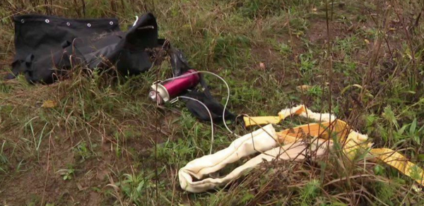
However, looks like the chute was activated, at some point
A testimony says the that the clouds were low.
METARs for Dole Tavaux (28NM away):
METAR/SPECI from LFGJ, Dole Tavaux (France).
SA 28/09/2020 11:30→
METAR LFGJ 281130Z AUTO 18007KT 9999 OVC007 12/11 Q1013 BECMG
SCT008 OVC020=
SA 28/09/2020 11:00→
METAR LFGJ 281100Z AUTO 18006KT 9000 OVC006 11/10 Q1012 BECMG
SCT008 OVC020=
SA 28/09/2020 10:30→
METAR LFGJ 281030Z AUTO 20008KT 8000 OVC007 11/10 Q1012 BECMG
SCT008 OVC020=
SA 28/09/2020 10:00→
METAR LFGJ 281000Z AUTO 21006KT 9999 OVC007 12/10 Q1012 BECMG
SCT008 OVC020=
SA 28/09/2020 09:30→
METAR LFGJ 280930Z AUTO 20006KT 9999 BKN007 OVC012 12/10
Q1012 BECMG SCT008 OVC020=
SA 28/09/2020 09:00→
METAR LFGJ 280900Z AUTO 20006KT 9999 OVC007 11/10 Q1011 BECMG
SCT008 OVC020=
SA 28/09/2020 08:30→
METAR LFGJ 280830Z AUTO 19005KT 160V220 9999 OVC006 11/10
Q1011 BECMG SCT008 OVC020=
SA 28/09/2020 08:00→
METAR LFGJ 280800Z AUTO 20005KT 9999 OVC005 10/09 Q1011 TEMPO
3000 -RADZ BECMG BKN020=
SA 28/09/2020 07:30→
METAR LFGJ 280730Z AUTO 22005KT 9999 OVC004 10/09 Q1010 TEMPO
3000 -RADZ BECMG BKN020=
SA 28/09/2020 07:00→
METAR LFGJ 280700Z AUTO 20006KT 9999 OVC004 10/09 Q1010 TEMPO
3000 -RADZ=
Conditons will likely have been worse than that at La Véze, which sits at a much higher elevation and closer to the Jura mountains.
The RNAV approaches at LFQM have rather high minima. Even if the aircraft was LPV-capable (not a certainty with a 2006 model), the cloudbase might have been too low for the approach. Visibility likely was not the problem.
If he did the approach to runway 05 (flightaware looks like it), then the crash site is indeed on the other side of the runway, i.e. after initiating a missed approach. Winds would have favoured runway 23 though.
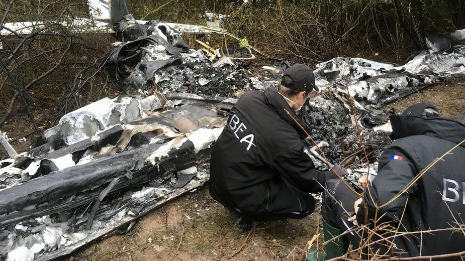
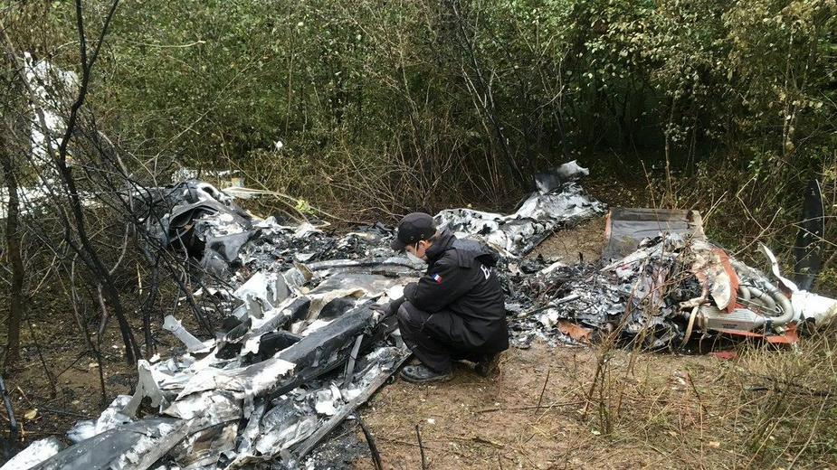
It might be a loss of control when going missed – when flying by hand. Not a lot left of it, due to a fire
The chute appears to have been deployed but perhaps too low.
The last flightaware track indicates he would have been on a left base for RWY23, but still at 6000ft while LFQM is at 1270ft. The initial and intermediate segments on the instrument approaches to RWY 23 (RNP or NDB) are all at 3500ft.
The village of the crash is also on the first plateau like LFQM, it’s 5km straight east. It is on the same side of the little ridge that runs SE of there. The small wood with the crash is basically on the final for RWY23.
The second article (in french) quotes the farmer as saying the layer was about 100m from the ground. When he saw the plane coming out of it, there was simply nowhere left to go and no time to react. Another person says the last communication with the tower did not indicate any excess stress or sign of problems.
The prop blade visible on the second picture published by Peter seems to be intact. It looks like the prop was not spinning under engine power by the time of impact. Does the activation of the chute switch-off the magnetos?
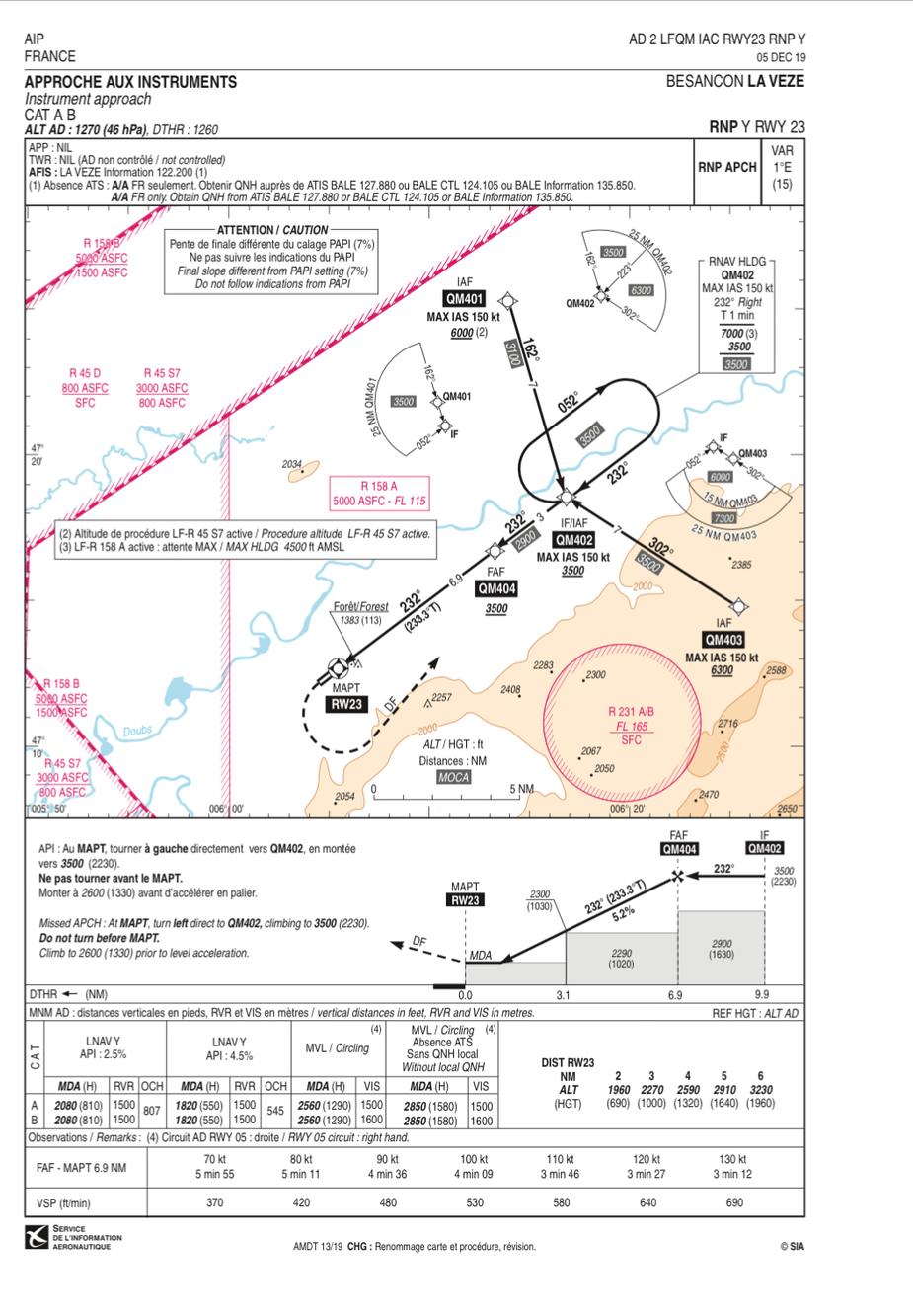
The LNAV 23 doesn’t appear to be unconventional, although I see the French use percentage gradient instead of degrees for the CDFA, but it translates to around a standard 3 degrees based on rate of descent at 100 knots.
As usual very sad when this occurs, hopefully the investigators will provide some insight on the reason for the accident.
Peter wrote:
The chute appears to have been deployed but perhaps too low.
IIRC is has happened that chutes have been deployed by impact forces and not manually.
RobertL18C wrote:
The LNAV 23 doesn’t appear to be unconventional, although I see the French use percentage gradient instead of degrees for the CDFA,It is normal to give percentage gradients for 2D approaches – the UK does, too. AFAIK, 2D approaches are never charted as CDFA in AIPs. Jeppesen does chart them as CDFA.
@Airborne_Again I must get out more, I hadn’t realised people used any charts other than Jeppesen :)
I think the percentages relate to the missed approach climb not to the CDFA. API normally relates to approach procedure interrupted. According to the local media, witnesses say they thought they saw a parachute before the crash.
Why not use the SIA approach charts, they are easy to use and best of all free?