This issue seems European-only, so I don’t see a DME-DME GA station being developped and certified by a private company on its own money 
According to this, VOR/DME reception will be guaranteed over France at or above 3500ft. It would be positioning from a single VOR/DME, instead of 2 DMEs.
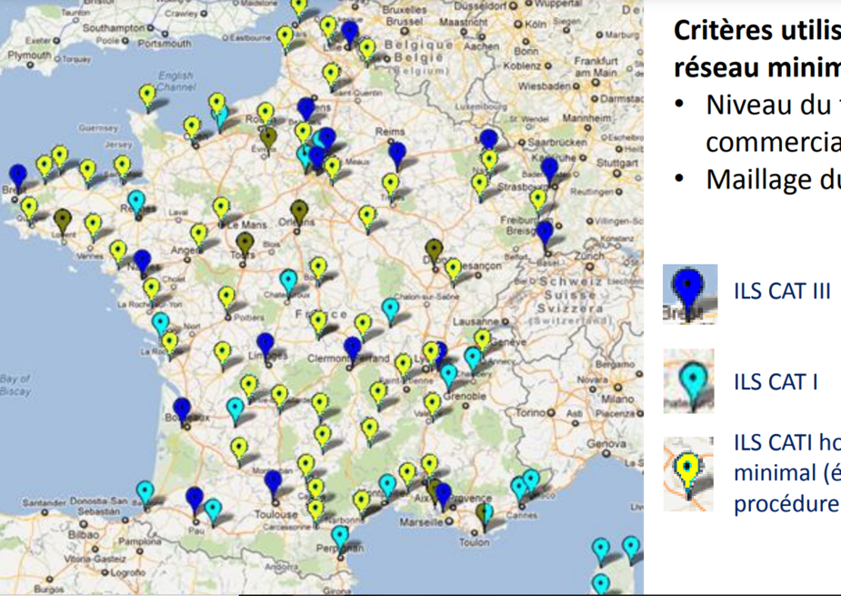
Apart from a minimal ILS network, ILSs will be removed unless the airport operator takes wants to keep it at his own expense.
The minimal network are the blue (light and dark) dots on this map :
Jujupilote wrote:
Only an approved GPS
Maybe I’m wrong, but a GPS is all you need in Norway to fly IFR with a GA aircraft. But for commercial aircraft, as well as ambulance and other stuff, you must be able to fly also if the GPS signals should fail. However when all radars are gone, and only WAM/ADS-B is left then what? WAM/ADS-B is also dependent on GPS.
I wonder how much longer the already enormously deskilled trade of what is called Air Traffic Control will survive the coming technology?
RobertL18C wrote:
Presumably someone might introduce a DME-DME for GA
Don’t think so – beyond the cost (given the marginal benefit as GPS works most of the times) – there’s also the capacity question with DMEs: As a DME ground station can only handle a limited number of requests at a time it can easily lead to frequency congestion when every GA plane starts to fly with a DME/DME navigator…
A DME-DME “navigator” is totally technically possible.
If congestion was a risk one could poll them less often; say every 30 secs, and use a cheap AHRS to DR in between; a €10 3 axis accelerometer chip should be able to do 30 secs within 0.1nm at 150kt
The only tech issue is reception at low levels. Strictly speaking, flying at a few k or below, you will be outside the DOC (the official coverage volume) of a DME, a lot of the time. Especially TDMEs. It actually works a lot better in practice, but…
Also there is a method which uses only one DME; a Concorde pilot told me their FMS uses that. It is quite cunning. It involves solving hundreds or thousands of simultaneous equations. It is also used in placing satellites into orbit; you have just the one ranging variable there. It does require an occassional reception of another DME, or knowledge of GS or some such. The satellite application eliminates the unknowns because the orbital mechanics are fixed, so the precise orbit can be determined just with one “DME” on the satellite.
The problem is the return on investment, after you got it certified. Nobody actually knows if it would sell. My feeling is that it would sell to a few smart people on EuroGA but the hordes of the great unwashed would stay with their GNS430 because, hey, it works every time I fly, so wot is da problem?? And if the 430 blows up I have my skydemon 
For the American homebuilt market, it would sell if you made a slide-in x430 replacement, i.e. a WAAS GPS with DME-DME. In Europe, it would not sell; the market in Annex 1 touring is way too small.
One small issue is that you have to sell a database of DMEs, to be updated periodically. HEY now you have a regular revenue stream so you can talk to investors
In the certified sphere, you might sell more FOG INS boxes; see some previous threads. I think you can buy a box for 5k (100+) which has a triple FOG, GPS antenna one end, and NMEA coming out the other end. I was going to buy one to play with; legitimately driving a tablet moving map, and of course nobody is going to install a toggle switch on the output of a GNS/IFR box because, hey, the STC drawings don’t show that
This is going to be a real mess if each country has their own GPS backup solution as implied by the feedback here from France and Norway, plus Switzerland as mentioned in the OP, just to take 3 examples.
But it certainly does point to further life for DME, regardless the details of the solution. Some sort of GPS backup is needed. Without tearing apart all the obvious caveats and details, here are a couple real-life examples:
1) GPS interference:
Wireless controls fouls airport GPS
2) RAIM outage:
LSSN B0206/21 NOTAMN
Q) LSAS/GAAU/I/NBO/A/000/999/4729N00934E
A) LSZR
B) 2102011211 C) 2102040642
D) 01 0912-0954 1633-1645, 02 0547-0625 0631-0650 0908-0950
1628-1641, 03 0543-0621 0627-0646 0904-0946 1624-1637, 04 0538-0617
0623-0642
E) GPS RAIM IS NOT AVAILABLE FOR LNAV.
LSSN B0210/21 NOTAMN
Q) LSAS/GAAU/I/NBO/A/000/999/4724N00839E
A) LSMD
B) 2102011213 C) 2102040642
D) 01 0911-0953 1632-1645, 02 0548-0651 0730-0735 0907-0948
1628-1641, 03 0544-0647 0726-0731 0902-0944 1624-1637, 04 0540-0642
E) GPS RAIM IS NOT AVAILABLE FOR LNAV.
LSSN B0212/21 NOTAMN
Q) LSAS/GAAU/I/NBO/A/000/999/4711N00725E
A) LSZG
B) 2102011252 C) 2102041637
D) 01 0909-0950 1631-1646, 02 0458-0503 0551-0652 0730-0735
0904-0946 1627-1641, 03 0454-0459 0547-0648 0726-0731 0900-0942
1623-1637, 04 0450-0455 0542-0643
E) GPS RAIM IS NOT AVAILABLE FOR LNAV.
How much does it cost a year to keep a VOR in service? NDB?
I do know an airfield close to me looked at string up an NDB and they were quoted 65K. But I have no idea what the running costs are.
@Bathman, for an NDB the biggest cost by far is the calibration flights. The transmitter itself costs next to nothing to run, and I know of at least one NDB that has been off the charts for many years but is still running and being used by a flight school for training purposes.
GA did have a multi sensor area navigation unit at one time but the market was so struck by GPS that it never really got a market foothold.
The Narco STARNAV used VOR/DME and GPS this before GPS was certified for IFR used VOR/DME to verify the GPS position but used the GPS as the data source for IFR flight as long as it had the conventional navigation plot backing it up, it also had an input for LORAN data.
I can’t help thinking that with modern data processing it would be easy to auto tune two DME units and access the GPS database to get the best navigation solution from four or more DME stations rapidly tuned automatically. The question is would such a unit be a commercial success?
Skyforce produced a portable unit that used a minimum of 2 VORs to produce a position. Unfortunately this was just before GPS so the project was doomed. It was accurate enough if the geometry for the cross-cut was good otherwise it needed 3 VORs.