Hello,
Having recently completed my EIR I am not at ease when interpreting the wetahercharts for an IFR flight.
Considering the need to be able to land VFR and the lack of desire to have a whole flight in the clouds I find it rather difficult to make a go/no-go decision
Note the plane is a regular DA40 or PA28 (no FIKI).
I understand that Thudnerstorms, CB, TCU and icing at the level of light/on the path are clear no-go.
Flight path is approximately the one in yellow from N to S and level would be FL80/90
I would welcome some insights/corrections of my interpretation on following cases:
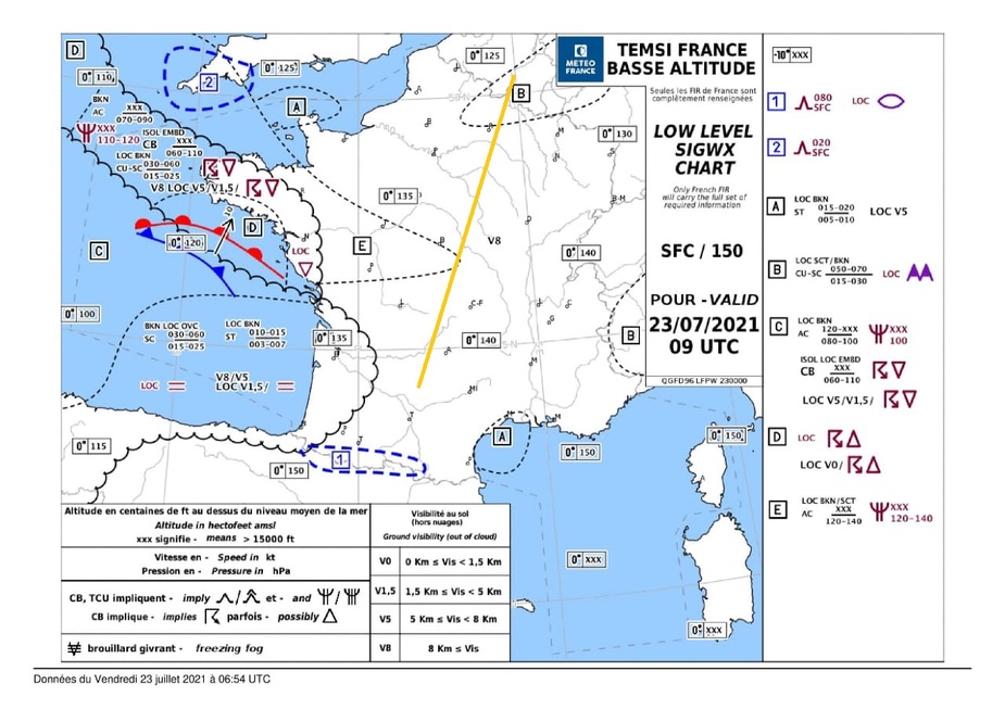
I would say rather yes, I do not see much issues.
Following cases are subsequent charts of 31/07
First 6UTC
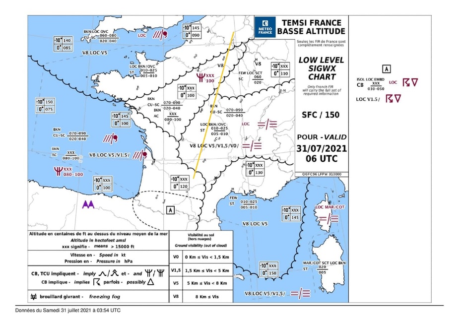
Icing could be an issue. Flying at FL80 would mean in/out of the tops on the flight. Unsure of that one
Then 9UTC
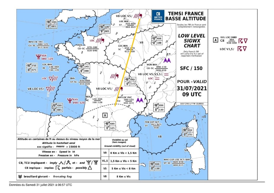
Unclear how I should interpret first part of the flight. I see that tops are at 020-030 but on left side of are these are shown at 070-100 with 0° at 085
Flying afterwards at FL90/100 should bring out of the clouds and in postive temp range.
For the arrival I wonder if zone A would not become an issue with EMBD CB… while gramet seems more positive
Final one:
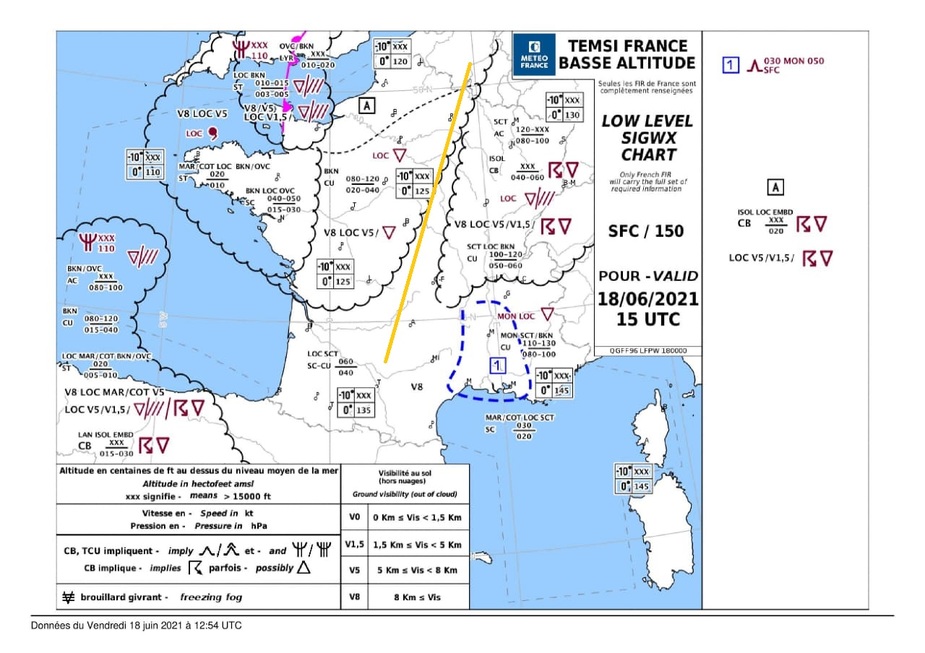
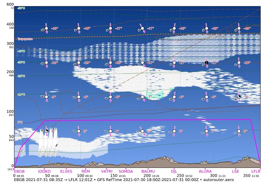
Flying out of the clouds in zone A then climbing to FL090 seems fine as at top of clouds and out of freezing…except that on the right side of the route it is not that positive.
Thank you in advance for your views on this.
jfw wrote:
I understand that Thudnerstorms, CB, TCU and icing at the level of light/on the path are clear no-go.
Not necessarily. If the TS/CB/TCU are isolated and not embedded, you can avoid them visually.
As for your weather scenarios, they all look ok to me. Specifically:
First 6UTC … Icing could be an issue. Flying at FL80 would mean in/out of the tops on the flight. Unsure of that one
As this is a forecast, the 0° level could be lower than FL100, yes. But in that case you would not have to descend much to get above the 0° degree so I wouldn’t worry much.
Then 9UTC … Unclear how I should interpret first part of the flight. I see that tops are at 020-030 but on left side of are these are shown at 070-100 with 0° at 085
The 070-100 tops are quite far away, while the 020-030 are right on your path.
For the arrival I wonder if zone A would not become an issue with EMBD CB
Locally embedded CB…You are getting to your destination anyway. If you are in clouds when approaching zone A, you could descend and cancel IFR earlier.
Flying out of the clouds in zone A then climbing to FL090 seems fine as at top of clouds and out of freezing…except that on the right side of the route it is not that positive.
Those CBs are isolated and not embedded. You should be able to see them.
I would ditch these old fashioned wx maps and use windy.com. Select the ECMWF model and see a much better picture.
The old charts were designed for big jets, which always fly IFR, have great ice protection and radar, and need to know about other stuff than “we” do.
The GRAMET is frequently fiction. It comes from GFS which is not as good as ECMWF, and the new ICON one is even worse since ICON manages the least accurate forecasts I have ever seen 
I would not any flight in IMC with any CB activity forecast. In VMC it is fine because you can avoid it visually, especially if – as is often the case – the cloudbases are fairly high. And use radar (meteox.com) and sferics before flying.
I agree with Peter I just get ECMWF Windy view, I found the rest of significant WX charts to be consistently useless, the GRAMET cuts along the route may not be adequate when you start moving out of your planned route or start crossing fronts in different spots & timing, I would not rely solely on these for the en-route portion but on depart/destination they could give a better view but worth checking against TAF/METAR, sometimes I get some puzzling comparaisons: 3km vis & 500ft celing on 2h TAF vs CAVOK in GFS…
As long as there is chances of visual avoidance at my level I would still fly with isolated CB in the forecast, the caveat is I need a low surface dew point is low (bellow 15deg) then no more than bumpy isolated CU/TCU that make nice pictures and wonderful flights with occasional bumps, when dew point is higher than 25deg, I don’t bother classifying clouds, even the fluffy cumulus CU is too bumpy to fly inside
For embedded CB, Ideally the forecast need a good spread dew & temps (10deg should give descent cloud-base) and I also plan to fly low VFR in VMC if IFR in IMC turned to be crap (notams, airspace, safe altitude, en-route diversions and fuel for long detours)
The fact that one need to land VFR on Y-FPL require a much thorough and wide WX briefing and complex YES/NO making than I-FPL flight
I use Windy mostly. I’ve been really caught by Gramets so never use them now. I practice quite a bit by looking at the forecast, paying a lot of attention to historic satellite data, and then do my own extrapolated forecast for 4, 8 and 24 hours to try and get familiar. Works well for me. ForeFlight is useful too but always always overdo icing conditions to stop themselves from being sued I guess. Always avoid embedded CBs.
Charts as above I use only to have a hi level picture on the frontal systems, mostly I use Windy lately, DWD (has some good general forecast descriptions per area) for the ice prediction and local weather forecast (not some international forecast) for me. Just before departure a run a couple of METARS/TAF in telegram or have a look at Orbifly to see all METARs. Convective weather avoidance is always the most difficult part due to the unpredictability and very fast evolution from CU to TCUs…CBs
Regarding the use of Windy, how do you use it in practice? I’ve got it downloaded but it seems there are a lot of features.
Light aircraft IFR is all about plan b’s, plan c’s and escapes in my opinion. I am sure you know about fog, low vis and landing minima, and you might know about takeoff minima (which seems to be less well understood). Assuming the weather at departure and destination (and alternate!) is OK, then really three big things to worry about enroute are terrain, icing and CB’s, which you seem well aware of. Forecasts are forecasts, they are not 100% accurate, and sometimes quite a way off that. You can improve your chances and information gathering by using something like Windy as mentioned above as it gives a better picture than a SigWx once you get used to using it.
I fly a PA28 with no FIKI and no weather radar or stormscope, I will generally give an IFR flight a go and deal with weather en-route. The things that I have no defence against are icing and embedded CB’s. For that reason – I will normally try and plan the flight below freezing level unless I can be pretty sure that I won’t be IMC for any significant time. This does mean having a backup plan if needed – one of my worst fears is being stuck at MSA in icing conditions, so generally if I do plan to go above freezing level I will not fly in an area which has an MSA close to or higher than the freezing level. Assuming no icing issues, flying in cloud for hours is not the most scenic (and quite tiresome if no autopilot) but there is nothing wrong with it. The problem is when there is embedded CB/TCU around. In this case I will not do a long cruise in IMC, because I have no in flight information against running into something nasty, so it’s either get VMC on top and avoid the lumpy stuff visually, or stay below it if I can’t do that. Obviously if they are isolated then you should be able to avoid them individually anyway.
Things that would almost immediately stop me are very low freezing levels for the route with solid IMC forecast, and significant CB/TS activity, especially if it’s a really grey day and it’s likely to be embedded. In these cases I will either go VFR below or scrub the flight.
I know this hasn’t been a direct answer to your questions, but whilst planning is important, weather is weather and can, and often will be different than forecast, so it is useful to have a think about how you might deal with various possibilities. I also found the IR course extremely lacking in teaching real world IFR, and I had to learn a significant amount very quickly when I got my first job flying an old piston twin on a 24/7/365 operation. A lot of the learning experiences were less than pleasant.
Personally I find the TEMSI charts one of the best for GA. They are done by meteorologists, not computers, and they are usually very accurate.
A lot of stuff can be taken from online sources, but nothing replaces SWX charts of this quality. Switzerland and Austra also have one common Low Level SWC, so has Germany.