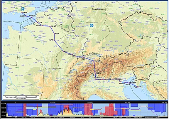
What were the jetstreams like? You were flying quite high.
They are forecasts and winds are the average between sampling points. Mostly upper winds are determined by satellite sampling rather than observed measurements so up to twice the average is not uncommon. I recall coming down the centre of the UK in a Jetstream with all the nav kit switched off (Standard V Bomber stuff) We thought we were over Birmingham but when the radar was switched on we were just approaching Thorney Island! Met is a good guess, nothing more.
My opinion aswell, just the difference between the forecast and reality.
At what altitude are the GFS Winds being forecast? If it’s 2000, 5000 or 10,000 ft, maybe that explains it.
The wind maps are 500mb (see the label at the top) which is about 18000ft, which is about where we were.
I normally find there is very little difference between say 14000ft and 20000ft.
On this occasion I suspect that our route just happened to lie in the worst possible place between the low (N of Germany) and the high (W of Ireland) and the positions of these were very different to what the forecast MSLP charts show. In that case you get squeezed into a fast airflow which is driven maximally by both at the same time.
Great story about Thorney Island, Tumbleweed  Aren’t you glad the Russians didn’t invade during the cold war? Finding Moscow in IMC might have been fun…
Normally 100, 200,300,400,500, 700 hPA
Almost every modern airliner today (at least Airbus) is sending down spotwind and temperature values automatically for meteorological processing. Via ACARS.
40 years ago e.g. on B707 the copilot had to take wind and temperature data (so-called Aireps) on long distance flights and forward the form to the met office at the destination airport. Mostly done by airline personal of the station. To get the data earlier Gander or Shanwick Oceanic when releasing flights over the North Atlantic added to the clearance “Send Met Reports”. Then winds and temps were to be included in the position report.
Of course the automatic measurements of today are mostly taken in the upper “jet” levels, not at 500mb. Maybe a source of ambiguity.
I think it is critical for range considerations if your flight path crosses stronger winds perpendicularly for a longer period of time. In the planning phase the wind may give you a slight tailwind component and when you are actually in the air the axis of the wind field perhaps shifted by 20 degrees and you are experiencing (unexpected) headwinds.
As with the aerodrome forecasts it is important to always have the latest version of those charts (range critical flights). Anyhow, I often saw wrong predictions …more with the TAFs than with the winds.
The GFS site I use will plot whatever height you want.
For planning purposes I disregard a tailwind, and regard a headwind at its max forecast figure. However I also have a GPS linked fuel totaliser, accurate to 1-2%, and that is what enables diversion decisions to be made.
However it might sometimes be smarter to take a different route entirely – if the strong wind is concentrated in a narrow corridor.
[edited to remove the URL – not working]
For planning purposes I disregard a tailwind
Why?