Agree with the above.
Bobo, there is presumbly nothing better than having some gliding experience in the mountains. You certainly have a better basis than I had when I first flew motorized aircraft in the Alps.
I wouldn’t make too much of a science out of it. Just read a book like Sparky Imeson’s, abide by a few golden rules (initially fly only in very good weather, etc.) and then make your first flights.
If you want to invest more effort into this, just take an experienced mountain flying instructor along on your first couple of flights into the mountains. No need to be formal about this and take a “mountain flying course”. You can such instructors at every airfield in the vicinity of the Alps. In Germany, the flying school at Kempten (EDMK) is well known for this. Otherwise just pass through Mannheim when flying down. 
Another vote for the late Sparky Imeson’s “Mountain Flying Bible”. I have flown a good deal in the Rocky Mountains and I would highly recommend the practical advice and rules of thumb suggested in this excellent book, to anyone considering mountain flying.
Boscomantico’s summary of Alpine routes above is very good too, I have been on many of these routes and the techniques I learned in America have served me well in Europe. There should perhaps as he suggests be a structured mountain flying course that concentrates on practical VFR techniques for normal flying in mountains rather than getting a short-duration rating for the special altiports.
Bosmantico, that’s a very informative post, thank you. I am hoping that this coming season will finally be the season that sees me doing a lot of VFR flying between UK, Switzerland and Croatia and I shall be referring back to your post nearer the time.
Interesting thread. I’m going to Las Vegas, USA in April.
Thinking of renting at Henderson (KHND), Vegas and flying over Grand Canyon and land at Grand Canyon National Park Airport -6609 ft (KGCN) (I have a validated license). Has anyone here done that? I guess a airplane checkout at Henderson would consist of some mountain flying intro?
I would be happy for any suggestions or tips for this trip :)
Jonas
Jonas,
well, flying the Grand Canyon (via the published corridors) really has very little to do with mountain flying, since you will be thousands of feet above the ground. Just some consideration of density altitude is required, but that’s it.
However, yes, most flying schools / rental outfits in the southwest seem to require some type of mountain checkout nowadays, irrespective of where exactly you intend to go afterwards.
Don’t fly into GCN, though. It’s mainly for the commercial air-taxi operators and they are not too fond of private spamcans.
Instead, fly into Grand Canycon West (1G4). They do want to sell you a tour to the Skywalk, but I think it is worth it.
As regards the corridors, coming from the south, I flew:
-Fossil northbound at 11,500 ft., then
-Dragon southbound at 10,500 ft., then
-Zuni northbound at 11,500
and then via Marble Canyon to Page
which is a nice tour.
Does anyone know of a general chart for VFR routes through the Alps? OK the Swiss VFR chart marks the main passes, but I have in mind an Alps-wide chart of recommended conventional routes, something like the one Colorado publishes for that state’s mountains.
boscomantico,
Thanks for the info, i was not really sure what to expect, looking forward :)
What a great topic it has become! Bosco and others thanks a bunch. I’ll be sure to print this and take it with me. I agree with Bluebeard, it would be nice to have some maps with the suggested routes.
I don’t know if there is a better option but for the Alps I would use the Jepp “VFR/GPS” charts, which were last published in 2013, and are now discontinued.
They still exist in paper, and also exist in an electronic version called Raster Charts, which can be run as a GPS moving map, in FliteMap and at least one other way I have come across.
Last time I flew with the Swiss “ICAO” chart (2004) it was rubbish, mixing feet and metres for spot elevations, and this has probably killed a few pilots who were doing a bit of unofficial IFR. I ended up flying 3.2 times lower but fortunately I was VMC at the time.
Quote
Interesting thread. I’m going to Las Vegas, USA in April.
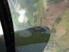
I’ve never tour-rented from LV (I did aerobatic training there) but have tour-rented from Grand Junction. If you fly up the Colorado River, theres some spectacular scenery, and you can fly deep into the Gray and Desolation Canyons of the Green River. The guy who allowed me to do that with his Pa28 has unfortunately move to a non-aviation business. These pics were taken through the open vent of the Pa28-181. I needed the 180hp.
Link to my Flikr if the embedding doesn’t work: http://www.flickr.com/photos/27183900@N04/