
That is interesting but it doesn’t appear to explain why huge areas of, basically, rain or drizzle are totally missing from meteox. In the 17/8/2018 LFBP case the rain was heavy enough to soak me in a few mins and the tops were around FL140 (and I would not have attempted that departure if I did not have full TKS).
There may be a technological explanation for it but it surely is simply not right to not show what most would regard as relevant weather.
Fortunately the Golze ADL product shows it.
If it is drizzle, it could not show up. As you can see from the images, the actual Doppler rain radar is there as well as the Golze ADL product results. Light drizzle is not always shown with all products, but if the rain is heavier it should show up in most products as they all use the same Doppler Radar stations, but just smoothen out a bit different in their own way. That is also why you might fly through an area which is depicted green in the ADL app, but not seeing any rain or only a few drops or very light drizzle.
I’ve merged the last thread with a previous one on the same topic; that time comparing meteox.com with sat24 and again showing big differences.
The differences you are seeing between images for the different apps is related to non-meteorological processes each app is using to display the data. I can tell the apps are using different color tables (i.e., which values of reflectivity correspond to dark green, yellow, orange etc.). It is also likely there is some post-processing occurring after the radar data have been measured and calculated. Some apps perform an extra smoothing to make the raw data more pleasing to the eye. Raw radar data can be very noisy and difficult for un-trained people to read. Smoothing averages out much of that noise and makes the larger-scale picture more clear. There may also be some degree of spatial interpolation to transfer the raw data from its native grid (plan-position indicators on conical surfaces) to the Cartesian grid most likely being displayed on the apps. This requires both horizontal and vertical interpolation, and the scheme used, as well as the final destination grid on which the data are plotted, can impact the final appearance of the data as well.
It is highly unlikely that different radar sites are being used to generate the data you’re seeing. I know Europe has a pretty large radar network, although I’m not sure how well the different countires cooperate and share data with each other. For weather purposes, they probably do share, so you are probably seeing data from the same root sources, just manipulated in post processing as I detailed above.
This is the response I got from Jeff Duda on the differences in images from several apps as to how they display rain at a specific location and time in a different way.
Jeff Duda, Professor and Post-doctoral research associate
University of Oklahoma School of Meteorology
Peter wrote:
Right now, south east UK, there is drizzle.
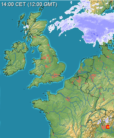
I would say this is in fact no radar data. The weather area between the UK and Norway could not be depicted that way. There is a big gap in radar coverage in this area:
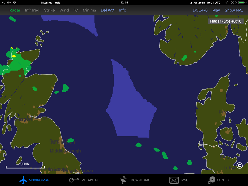
There isn’t supposed to be a blind spot over the SE UK though 
Thinking of the UK, we have the Met Office, and throughout europe Meteox and Windy provide useful services as well as the other national met offices.
I find that at the same moment in time on the whole Meteox and Windy are identical, so I assume use the same feed, but are often out of line with the Met Office. I cant imagine that they have a different feed from the national weather office who probably closely guard the data.
I wonder if the differences are due to how the data is interpolated or some other reason? The differences I find can be quite substantial.
In terms of more sustained weather I find Windy remarkably accurate. On a recent trip there was a large but isolated block of weather that Windy indicated had a base of less then 500 feet and tops of 12,000 feet. I was tempted to go through it but had a little reservation from the passengers point a view of just how unpleasant the ride might be – I did look to go under and found the tops and the base were almost exactly as predicted. I thought that was quite impressive given their modelling.
Windy Satellite feed is EUMETSAT and Weather Radar feed is Met Office, it’s written on the top right of the screen !
Ibra – yes would account for the difference, but are each actually using different satellites and does the data come from weather sats in fixed orbit? I had assumed it is ground based radar?
I believe the satellite(s) are geostationary. They offer updates every minute.


