
Thank you all.
One recent example was Annecy LFLP:
Z:

Y:
X:
Presumably only the Y version can be flown procedurally (i.e. without vectors).
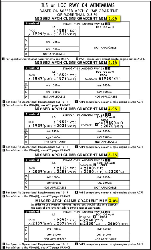
All three have the same basic DH of 800ft, based on a 2.5% climb on the missed approach.
As an aside, a lower DH is available if you can climb faster than 2.5%:
Peter wrote:
Presumably only the Y version can be flown procedurally (i.e. without vectors).
Why do you say that? I can’t see that any of them require radar….what am I missing?
Peter wrote:
Presumably only the Y version can be flown procedurally (i.e. without vectors).
Each of them can be flown procedurally:
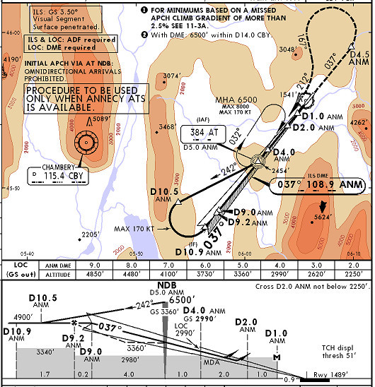
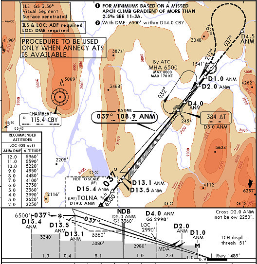
- Z – arrive at CBY, leave it with QDR 120, descend to 5000’ at D1.5, descend to 3000 at D6.5, turn heading 082, clear for ILS approach  that’s what ATC would say and that’s the procedure
- Y – arrive at AT at 6500’, make holding if necesarry, make procedure turn descending to 4900’ and enter ILS
- X – arrive at TOLNA at 6500’, leave it QDM 037 to ANM and enter ILS
Yes, Emir, I agree. I didn’t read them properly.
I think X cannot be flown using “classical” IFR, non-RNAV, because how would you get to TOLNA? Other than by flying the back course (not allowed in Europe AFAIK) and then a procedure turn at TOLNA.
BTW
turn heading 082
should be a track of 082.
Peter wrote:
I think X cannot be flown using “classical” IFR, non-RNAV, because how would you get to TOLNA
TOLNA is defined as DME19.0 at radial 217 ANM so you can fly to it from your previous point in your flight plan (which was also defined somehow). I’m not saying that this is easy without GNS but it is possible. When taking IR training I was flying routes up to 500 NM with steam gauges (HSI, VOR, DME and ADF) without GPS and it can be done
I guess X would be flown if arriving from southernly directions.
Peter wrote:
should be a track of 082
No, I believe this is heading 082. Track would implicate you have some navaid to rely on (assuming no GNSS to fly track from point defined with D6.5 at QDR 120 from CBY).
Yes, anything is possible but the intention in non-RNAV (non-GPS) flying is that every point has to be defined as a navaid, or a radial+distance from a navaid.
This discussion can get very theoretical e.g. how do you get to ROMTI, when initially arriving at the airport?
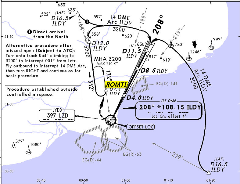
You can fly to the NDB, do a PT, fly up on a bearing of 352 until the DME reads 4.4… but that isn’t strictly speaking charted (even though it’s obvious). IMHO, ROMTI is a purely RNAV waypoint.
This is why I wondered if there are other reasons why ATC might issue one of the three options above.
Peter wrote:
IMHO, ROMTI is a purely RNAV waypoint.
First question is whether ROMTI is intended to be flown to as part of arrival. If it is (e.g. for holding in arrival) then it will probably be arrival from south (or SE or SW) so you’ll hit LZD, leave it QDR 352 and hit ROMTI at D4.4 ILDY – it’s quite obvious and I don’t see any problem. Then you enter offset holding flying heading 322 for 1 min and turn QDM 172 to LZD until you reach ROMTI again at D4.4 ILDY and then you continue holding. Leaving holding at heading 352 until D12.0 ILDY and initiate 14 DME Arc until you establish ILS.
I’ve flown similar procedure (ILS Y RW 12 at LQSA): arriving from BOSNA point to TIMID (D12.0 at KEB radial 309), flying heading 099 to enter the holding, turning at D8.0 back to TIMID and after one holding exiting at TIMID and entering 18 DEM Arc BHS for ILS 12.
IMHO it’s not teoretical.
I obviously agree as to the lateral navigation procedure but there are additional potential considerations concerning obstacle clearance.
We did that here before I think, quite a few times. If flying vectors, ATC is responsible for your obstacle clearance (except in Spain  ). If flying procedurally, you are, and initially you have to respect the chart MSA (SSA), then the MSA circle, then you fly to a charted IAF, then either fly the approach (as published) or descend at a charted holding pattern to the IAP platform and then fly the IAP. Elsewhere, obstacle clearance is not assured so one cannot necessarily fly along tracks even though they are obvious.
For example, are you assured of there being no obstacle on the straight track between LZD and ROMTI?
Peter wrote:
For example, are you assured of there being no obstacle on the straight track between LZD and ROMTI?
Yes, because the MSA in that sector is 2100!
AnthonyQ wrote:
Why do you say that? I can’t see that any of them require radar….what am I missing?
My (obviously too brief) question (unanswered) was that AFAIK, that non-procedural = radar vectors….it has nothing to do with RNAV.


