The root problem is trying to compare this with a conventional ILS (or indeed a surveyed LPV approach) – it is neither. It’s a free app running on a bit of cheap consumer electronics.
I would disagree, Steve.
What I said is:
Logically, where there is an ILS, the ILS GS should have been coded. Where there is a GPS/LNAV approach with a LNAV+V “advisory glideslope” coded, that glideslope should have been coded. That much is just obvious. Why code anything else? You may as well take advantage of the obstacle surveys which have been done, checked and published.
And I still can’t see what is unreasonable about such an expectation.
Let’s face it, if I was the developer, and somebody is going to test it flying into some ILS airport (which is a PROB100) and find it doesn’t match, I am just going to get a lot of support workload. On a free app especially, that’s the last thing I want.
For all I/we know, GPS-ILS was coded to match these approaches, and if that is so, I can’t see why the developer could not say that. Or was the database generated by an outside person?
As I say, copying surveyed approaches is a no-brainer. I will email the developer and ask him directly.
I suggested that he posts detail here but he has refused, describing the people here who were critical of it in less than polite terms.
Peter, was it really necessary for you to mention this? Seems petty and sure to further alienate someone who has developed an excellent app. And let’s remember it is just an app – and one that many people find useful.
I don’t think it’s supposed to be the approach, it’s meant to be an approach. Two quite different things?
There are also many, many airfields in the database that don’t have any kind of formal approach at all – so what would you compare those with?
I don’t think it’s supposed to be the approach, it’s meant to be an approach. Two quite different things?
Yes, but my question stands – IMHO. Why code something different to the existing IAP?
The existing IAP is not copyrighted.
It’s like Jepp coding approaches which are different to the AIP ones. They could, just for the hell of it. They could send a team to every airport and re-survey it. Why don’t they? Because it would be clearly dumb.
Maybe I am missing something…
There are also many, many airfields in the database that don’t have any kind of formal approach at all – so what would you compare those with?
Nothing. I have no issue with that. You have to fly such approaches in VMC first. I have designed some myself, and checked them in VMC.
One point which has been missed was that an esteemed member of the UK GA community took it upon himself to ‘survey’ various GA airfields and sought to create a database with the stated intent that the GPS ILS could then be used for real. From my perspective, it was at this point where I started to worry about how GPS ILS may end up being used, regardless of the ubiquitous developer’s health warning.
Dave_Phillips wrote:
From my perspective, it was at this point where I started to worry about how GPS ILS may end up being used, regardless of the ubiquitous developer’s health warning.
I wouldn’t worry too much about what other people do or don’t do. I personally find this app very useful. When approaching my home airfield in marginal weather, it’s much safer to do a DIY instrument approach than trying to scud run home from the neighboring IAP. Yet the former is illegal and the latter legal in Germany. Guess what I prefer.
Perhaps perversely, but I have no issue with the way it might be used. After all, it is an app running on a machine which is running hundreds of other threads, any one of which can crash it, etc. And most users will just use the internal GPS, which was probably optimised to find the local Macdonalds (one can use a proper external EGNOS GPS to get around that bit).
I have no issue with somebody coding the approaches. Somebody has to do it, and the developer is very good to make this a free app.
The Q which I was posting was different.
Just a final update in case anyone is interested…
I have not been able to get any more info from the app developer about the extent to which existing published approaches have been “matched”. He said the GPS-ILS GS is 3 degrees (which of course makes sense) but I have not been able to find out what happens at the steeper ILSs and LNAV+V approaches.
I can’t test it as I can’t think of any steeper ILS which I can test fly (London City, Innsbruck, Lugano are not accessible to me, legally or worth the avgas burnt to get there).
So the database compilation process remains a mystery even for published approaches.
As I said above, copying published approaches exactly is such an obvious no-brainer…
Peter wrote:
So the database compilation process remains a mystery even for published approaches.
It really seems so. I keep trying out this app every now and then, mostly to see if it would safely guide me to the nearest runway in case of total loss of onboard navigation capability. So far, I have not seen an approach that exactly matches any published approach. But from the approaches I have tried, I should be able to “tweak” the database by moving runway coordinates so that the computed glidepath matches the actual glidepath. Maybe the developer is interested to get these adjusted coordinates?
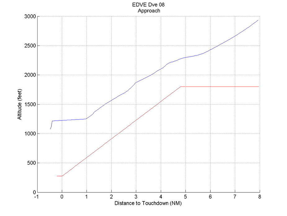
Below is an example where real life and app were apart by 500ft. A non-precision approach (GPS based) into EDVE, flown on autopilot along the advisory glideslope produced by the FMS in some turbulence. The runway has a slightly displaced threshold which has obviously not been calculated into the database.
Trying out the app I have come across two major problems with my Samsung phone and this program:
1. When the phone loses the GPS signal, there is no warning whatsoever. The display just freezes keeping the last ILS crosspointer position on screen, which is very dangerous if this were used as sole navigation aid. There is probably a little GPS annunciator on top of the screen, but that can easily be missed. Contrary, JeppView on the iPad, which shows only horizontal aircraft position anyway, will remove the aircraft symbol from the plate when GPS accuracy is insufficient.
2. When transmitting the approach path after landing for evaluation, the app has crashed two out of three times so far, losing all the datapoints it collected during the approach.
Peter wrote:
I can’t think of any steeper ILS which I can test fly
Altenrhein LSZR ILS has 4°. And your highway to Greece almost crosses overhead