Sorry for the dumb question, but how can it not be dangerous to do an LPV approach if there is a 500+ ft delta between the GPS altitude and altimeter altitude reading?
 So even if the DH was depressed, you should still, ahem, reach the runway OK
It is an interesting question though. If you have set the right QNH, the altimeter will read right at the runway regardless of temperature, so the issue must occur earlier, but LPV has not temperature dependent obstacle clearance issues. So why is there a problem at low temps? I can see check altitudes on the chart being wrong, the procedure platform (baro defined of course) will sink down, etc.
The GLO was giving me an accuracy of 6m and a correct altitude readout 223ft. Meanwhile the SkyEcho was stuck at 30m and regularly indicating 400ft altitude.
If that is their “WAAS” GPS, they need to fix their geoid correction. Maybe they did it only for the USA? If you are selling a WAAS box, and there is no WAAS outside the USA… At 170ft that error looks suspiciously like… what I have seen everywhere 
Peter wrote:
or the approach plate says the approach is not valid below some (very low) temperature; I vaguely recall seeing such notes somewhere
but LPV has not temperature dependent obstacle clearance issues. So why is there a problem at low temps?
tschnell wrote:
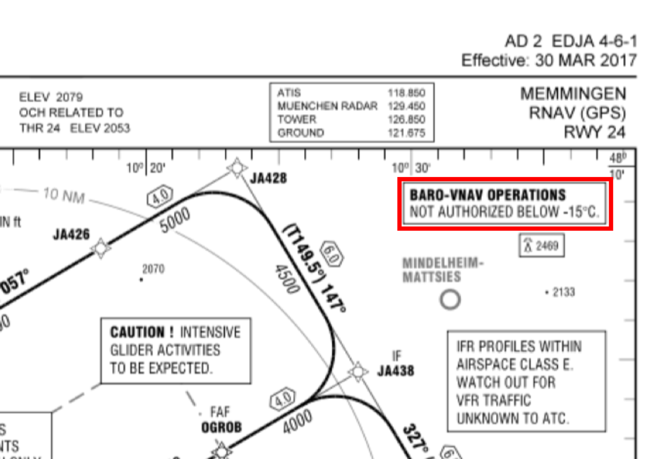
There is none, I think – same as with a “conventional” approach apart from a correction of the minimum when the temperatures are very low. What you have probably seen is a note on some approach charts that BARO-VNAV operations are not authorized below certain temperatures – and this makes sense of course, when a baro-input drives your glidepath indication. But I am not aware of any GA installation that uses baro-VNAV.
In very cold weather all legs of an approach can and probably should be corrected. The GPS altitude is only used for the glidepath.
I believe the Cirrus can use Baro-VNAV.
JasonC wrote:
I believe the Cirrus can use Baro-VNAV.
As far as I understand, the equipment for LNAV/VNAV-approaches does not exist for use in small airplanes.
huv wrote:
As far as I understand, the equipment for LNAV/VNAV-approaches does not exist for use in small airplanes.This is not correct – any SBAS-system will show you a gildepath also for an LNAV/VNAV-approach – it’s just Baro-VNAV that is not widely available.
[done]
any SBAS-system will show you a gildepath also for an LNAV/VNAV-approach
Tell that to Cambridge, Jersey and Guernsey ;-)
Tell that to Cambridge, Jersey and Guernsey ;-)
OK, so why don’t they?
Because they are classified as “BaroVNAV only” in the database.
I think that was because the money wasn’t spent to verify the glidepath for SBAS VNAV, probably because most of the aircraft using those airports are BaroVNAV equipped, but possibly because the people in charge didn’t understand the technology.
The MATCO of one of the three (no names!) came to me for advice on the subject, so I suspect was really quite ill-informed on the subject.
Timothy wrote:
Because they are classified as “BaroVNAV only” in the database.Interesting – I wasn’t aware that there are “Baro-VNAV-only”-approaches, and, looking at the AIP charts, there is no hint on the approach plates either…
chflyer wrote:
Sorry for the dumb question, but how can it not be dangerous to do an LPV approach if there is a 500+ ft delta between the GPS altitude and altimeter altitude reading? I can’t believe that happens. Or are we only talking here about deltas up in the higher flight levels?
The LPV glidepath is relatively fixed in space. On the surface of the airport, the altimeter setting is established by effectively setting the altimeter to read field elevation. So at the point in space, on the airport, where the altimeter setting is determined, all the temperature and pressure errors are eliminated. As you go up in altitude above the measurement point location and elevation, the barometric altimeter will largely adjust for standard atmospheric pressure lapse rate. So the main error in altimetry is due to temperature. The temperature error is zero at the airport surface and grows above that point and the pressure can vary the further you are from the airport. Fortunately, the location of the DA or MAP is very near the airport in elevation and distance, so the error in altimetry is usually small at the DA or MAP. So there is not much need for altitude correction at the DA except in the coldest of conditions. The error is not based on altitude per say, but altitude above the airport. So if you are going to land at an airport in the mountains, the error starts accumulating from the airport elevation.
At US airports where temperature corrections need to be supplied, temperature compensation may be at the DA, the intermediate segment, or the missed approach hold point. The worst place is usually in the intermediate segment because it has only a 500 foot obstacle clearance requirement and is higher above the airport than the DA and therefore the error is greater. The missed approach hold is often the highest altitude and therefore might need the most adjustment, but because the obstacle clearance is 1000 feet, it is lower risk. The DA point has the least amount of error, but the terrain clearance is also the least. The vast majority of airports in the US do not need temperature compensation for cold weather, and for those that do, the intermediate segment is most often the segment that needs compensation.