
Peter wrote:
the decision height is barometrically defined hence one is AIUI supposed to make some sort of temperature based adjustment on the DH, or the approach plate says the approach is not valid below some (very low) temperature; I vaguely recall seeing such notes somewhere
In the US, there isn’t any published temperature that applies to just LPV minimums or LNAV minimums. LNAV/VNAV minimums have a temperature limitation when the vertical path is determined by Baro VNAV equipment that is not temperature compensated. If an airport qualifies for cold weather adjustments, it applies to all IAP’s to the airport and to all runways and all types of approaches and is not limited to LPV.
Peter wrote:
most airports are at low altitudes so you won’t get large errors easily – one needs to be at a decent altitude, say FL100, to get an error of a few hundred feet
10,000 feet above the airport, 20 degrees above or below ISA at the airport, the error is 720 feet. If it was a near SL airport, then 10000 MSL, but if the airport elevation is in the mountains at 5000 MSL, the same error would exist at 15000 MSL.
The Cambridge (etc) issue was said to have been fixed by Jeppesen a few years ago. @bookworm might know more. But maybe it hasn’t? Last I heard it was a database coding issue, which prevented a +V approach being coded if there was a BARO-VNAV approach present. But, as usual, been there before 
Many thanks NCYankee for a great clear explanation!
looking at the AIP charts, there is no hint on the approach plates either…
Nope. The first you know about it is that it annunciates LNAV and you don’t get a glide path indicator.
That’s why you have to be prepared for such occurrences.
Is the +V option ever on the (Jepp) chart anyway?
bookworm wrote:
Surely baro-aiding is not relevant to a GNSS system using SBAS?
No, not in this context (approach phase up to MAP). It is relevant wrt missed approaches where the first leg is a climb on heading to altitude. Without baro-aiding, the pilot needs to manually sequence. With baro-aiding, the GPS will automatically sequence to the next leg once altitude is reached.
Peter wrote:
Is the +V option ever on the (Jepp) chart anyway?
I don’t believe so, but it does appear in the GTN.
But I trust that you are not confusing the +V option with LNAV/VNAV? They are very different beasts. I am willing to launch into the substantial differences, but not if there is no confusion.
Timothy wrote:
I don’t believe so, but it does appear in the GTN.
The +V never appears on a chart as it is a Garmin (and I assume Avidyne) product. It is usually available when there is an LNAV line of minima only as otherwise you would fly the LNAV/VNAV or LPV.
The problem arises in the Uk approaches Timothy mentioned where L/VNAV is disabled using SBAS but because it is still “there” in the coding, it effectively blocks the +V advisory from appearing.
@NCYankee, many thanks for the great summary.
Clearly then, any delta between GPS & altimeter altitudes in panel-mounts is almost entirely due to altimeter-related deviations from true altitude. In the context of the other thread where I originally posted, tablets, portable GPS, etc don’t have the same accuracy/integrity/continuity assurances which just emphasizes that they are not appropriate for IFR use except in the most extreme of emergency situations.
I should have thought of the temp element, as this is part of the IR curriculum and std ops in Canada and is covered at some length in the TC AIM. But of course -30C to -50C temps are common there this time of year. A Swiss source recommends use of the table any time aerodrome OAT drops below -15C which is more representative of much of central-northern Europe in winter.
Flyamax wrote:
VNAV utilizes a GPS created glideslope based on WAAS or baro-VNAV systems. For instance, I lfy with a GNS430W that never uses any baro input as it has no connection to any barometric source as what_next stated. @Bob tells us that the GTN750 has this and you need to know how it is handled. Which one it uses on an approach: GPS-related or baro-VNAV since baro-VNAV stays temperature limited and RAIM has to be checked.?
An IFR installation of a GNS430W will have the pressure altitude wired to the GPS. The pressure altitude is not corrected to local pressure and is usually has 100 foot precision. The pressure altitude is not used for vertical guidance, it is used for Baro-Aiding which is part of the RAIM/FDE algorithm which is used to determine integrity of the lateral position when not in an SBAS service volume with SBAS integrity information.
Flyamax wrote:
LNAV/VNAV approaches give lateral guidance only. RAIM must be checked when not using WAAS equipment. Here one has to know if baro-VNAV is used instead of WAAS. And the instructor seemed to emphasize that your GTN750 always uses baro-VNAV in place of WAAS.
The GNS430W is approved in the US to fly the LNAV/VNAV line of minimums using SBAS vertical guidance in lieu of Baro Vertical guidance. Some procedures at the fringes of WAAS in Puerto Rico have a note indicating that SBAS may not be used for the vertical and in other countries, this capability may not be permitted even when SBAS is available.
Flyamax wrote:
I read that there are LNAV+V approaches that are implemented depending on the manufacturer. It includes artificially created glide path for advise only. Then barometric altimeter will be the only altitude reference admitted in order to respect any altitude restrictions.
Yes. Advisory vertical guidance is not part of the approach design and is not a separate minimum on the approach chart. It provides a glidepath that can be used to make the descent from the FAF altitude to the MDA. It does not provide any protection below the MDA. In effect, it is an aid to pilots who wish to use the CDFA technique.
Flyamax wrote:
Perhaps anybody may correct me if this is wrong: baro-aiding is used as an integrity augmentation which gives the possibility to use a GPS independant source to give guidance. Thus, it requires only 4 stallites + the static source to detect any anomaly. I reckon that this is the reason why the GPS uses primarily a baro-VNAV are used. I heard somewhere that LNAV/VNAV approaches existed before WAAS and at this time you needed a certified baro-VNAV system to fly those apparoaches to the minimums
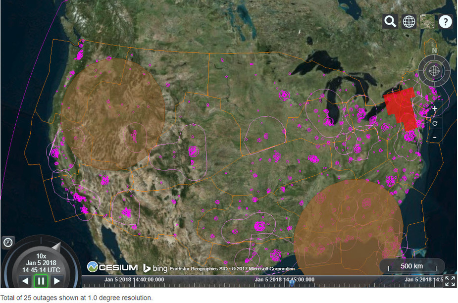
Baro Aiding is an enhancement to the RAIM algorithm, reducing the number of satellites needed to calculate RAIM. It is not used for vertical guidance at all. The availability of being able to calculate a RAIM solution is required as part of pre-flight planning when operating with a non WAAS GPS or in a non SBAS service volume. Since the RAIM calculation is dependent on the geometry of the satellite configuration and the operations of enroute (2 NM) , terminal (1 NM), and NPA (0.3 NM), the ability to calculate RAIM varies as a function of the operation. NPA is worst case and most in need of Baro Aiding. On any given day, there will almost always be areas of the US that will not support the RAIM calculation without Baro Aiding. As an example here is a snapshot of today. The red area will not support the RAIM calculation for NPA unless Baro Aiding is used.
AFAIK every IFR GPS has the pressure altitude input. The KLN94 has it too – the 10 or 11 Gray code wires. As NCY says this is used to help the RAIM thingy; I believe in cases when there are only 3 (or 4?) satellites being received and RAIM needs one more.
+V is implemented by Avidyne also so it must be Jepp who did the database coding for it (Garmin may be capable of doing database add-ons e.g. obstacle data for the handhelds, but Avidyne certainly aren’t, these days).
But I trust that you are not confusing the +V option with LNAV/VNAV? They are very different beasts. I am willing to launch into the substantial differences, but not if there is no confusion.
I have no idea of the difference.
I know what +V is; it is a synthetic glideslope coded as a line from the FAF to the MAP.
What LNAV/VNAV is I have no idea. It may be what bizjets have in the Collins Proline, which is capable of a synthetic glideslope on every published IAP (possibly only ones without any stepdown fixes, obviously). It may be a baro-derived synthetic glideslope? Hmmm, that may be baro-vnav…


