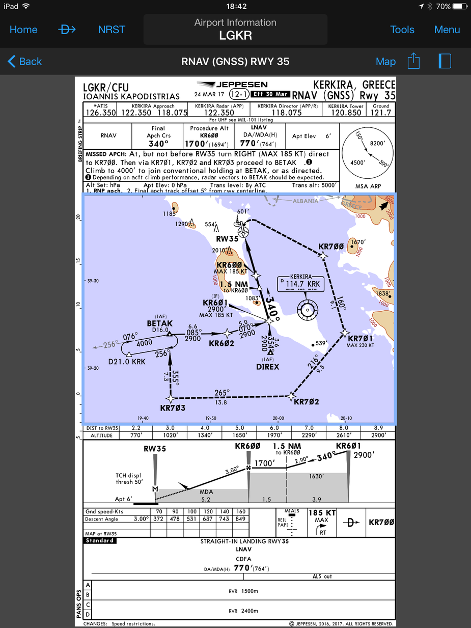
Here’s the plate.
The other approaches are VOR and Locator? Presumably the DME is co located with the VOR which is not at the RW threshold?
The RNAV may therefore be the only approach that counts down to the threshold?
There are several (similar) VOR approaches with DME distances and altitudes down to 2180 ft and DA 2000 ft.
Maybe I misunderstood the RNAV plate assuming that MAPt is defined at point of DA while MAPt is actually at RW threshold. Can someone confirm this?
It is, unless stated otherwise – FAA AIM “The missed approach waypoint is assigned a pronounceable name when it is not located at the runway threshold.”
(Source: AIM 5-4-5.d.5(d))
Thanks, now it’s clear.
Emir wrote:
Maybe I misunderstood the RNAV plate assuming that MAPt is defined at point of DA while MAPt is actually at RW threshold. Can someone confirm this?
The MAPt is always marked with an “M” in the profile view on Jeppesen plates. So in this case the MAPt is at the runway threshold.
RobertL18C wrote:
FAA AIM “The missed approach waypoint is assigned a pronounceable name when it is not located at the runway threshold.”
What the FAA says is not necessarily true outside of the USA. Particularly not for a procedure not designed according to TERPS.
Reviving this old thread because of kind of confusing situation I came across today when executing RNAV (LNAV) approach at Split LDSP. Here’s the plate:

Altitudes after DEXIS are given relative to runway threshold. However, on G1000 you can get only distance to SP402. It’s clear that SP402 is 2.8 NM from THR05 but it’s not easy to cross-reference altitude and distance like when you have approach which includes DME. Adding 2.8 to distances to SP402 read from G1000 and check altitude against the plate was easy today (CAVOK) but I wonder how this would work in IMC.
Poor mans solution: Pre-calculate the distances to SP402 and amend the plate while still far away from the airport.
As I understand this plate, if you fly the descend angle and as long as you are above 1200’ and before SP402, you should be ok to continue. Although I agree with you it would be great to have relevant altitudes that you can check every 1 NM, this is what I was taught as well.
There is a small difference between the AIP and Jeppesen:
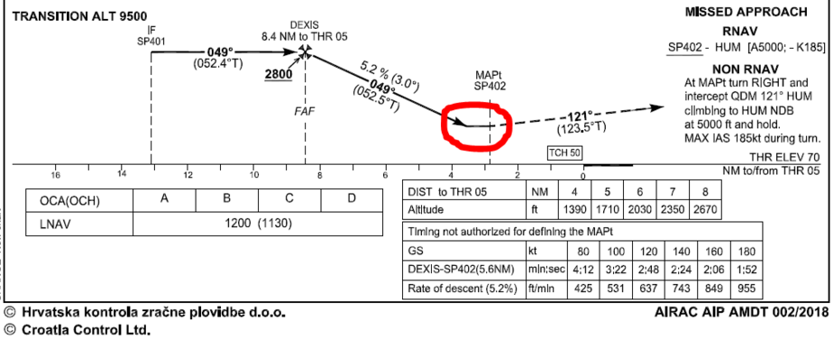
The AIP plate depicts that you can fly all the way down to 1200’ and stay there until reaching SP402 before going missed. However, the Jeppesen plate depicts that you should go missed as soon as you are down at 1200’, even before reaching SP402.
Please correct me if I’m wrong.
Classic case where having a DME is helpful. No easy way to show on a single GPS as the next waypoint is indicated. Suggest getting used to adding 2.8.or notating the distances to recalibrate vs SP402.