
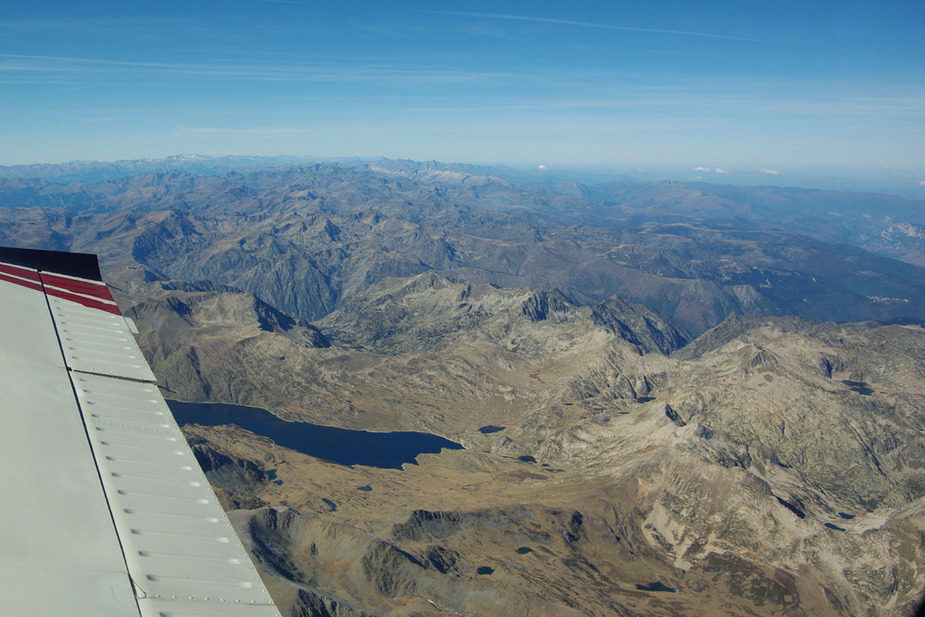
This

is spectacular but what would you do if you got an engine failure?
This is one solution
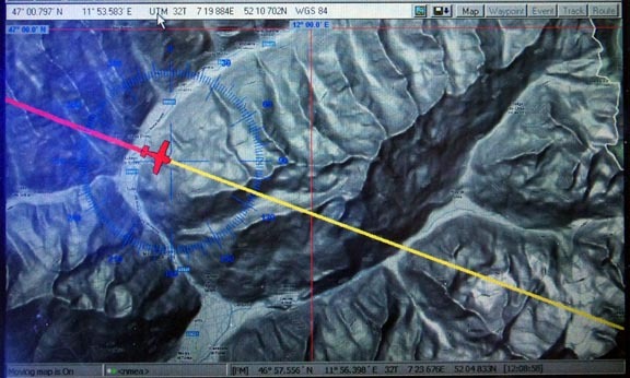
Good question. Your solution (please correct me if I am wrong) is to use your topical moving map and use this to guide you into one of the valleys?
This is what I would do
Think how I would combine a possible desecent in IMC and not hit terrain (sounds hard) while referencing said maps.
Question, if you declared a Mayday, would ACT be able to give you any assistance, assuming you were able to hold a two way conversation? While they would likely declare you responsible for your own terrain avoidance, could they, or would they give advice on areas definitely not to go? i.e Nxxxx, I suggest you turn right, your track is going to take you towards xxx mountain which has a base of 8,800 ft for example.
Question, if you declared a Mayday, would ACT be able to give you any assistance...
The only thing they really have is a minimum radar vectoring chart, so they could give you the direction towards the lowest terrain around you. And of course the direction towards the nearest airfield.
Synthetic Vision?
I know a guy to whom exactly that happened. Was on his way back to UK from southern France or Italy, some 10 - 12 years ago. He knew where he was (following his route on a paper topo map), aimed the airplane into a valley and hoped for the best. Came out of the clouds, saw a meadow next to a small road and put the a/c in there. IIRC the a/c was written off, but he and his family walked away with not even a bruise. Guess he used up his life's supply of luck that day.....
Synthetic Vision?
Today - absolutely! He didn't have that option at the time.
I'd first try to glide into the widest valley available, and of course I would have checked BEFORE the flight that there's space between the clouds and the ground. If that wouldn't work as planned then I'd pull the chute ... (Cirrus SR22).
I've done flights like that in my Warrior. Crossed the whole Alps on top in FL 125. When I did that I tried to have a perfect position fix every minute of the flight and I always knew PRECISELY where i was and where the next airports were.
Yep, syn vis.
Guess he used up his life's supply of luck that day.....
Yes I think very much so 
Synthetic vision should be easily possible these days on a handheld device. It was around more than 10 years ago, on PCs no more powerful than today's tablets (FS2000 on a 1GHz CPU) and it must be 5 years ago that I bought the NASA SRTM imagery for X-Plane on several DVDs for about €50.
Yet I haven't seen it actually working usefully. PocketFMS has it, but the demo I saw was extremely slow.
The Cirrus chute would be a very good option in this situation.
The topo map in my original post was a set of about 10GB of map tiles (10GB covering the Alps, the Pyrenees and various terrain north of Greece) which were generated using a tool called Mobile Atlas Creator (MOBAC), which rips the data off Google Terrain. Google (and all the other online map providers) don't like automated tile download, and the authors of MOBAC got threatened with legal action and removed support for all the useful data sources. However they left a way to put it back in using custom scripting...
The data I have runs under Oziexplorer which is just a generic GPS moving map tool. There is probably a way to getting it running on an Ipad.
I would have checked BEFORE the flight that there's space between the clouds and the ground
I think, most of the time, there is plenty of vertical room. Most areas of the Alps have plenty of flat valleys. The Pyrenees are a very different proposition, however...
While - alas! - not pertinent to Europe, AOPA FLYQ and ForeFlight have synviz.
The Garmin 795 has synthetic vision. I still have one of those around, so if anyone is interested :-)
Then, if you have an iPad, install e.g. AirNav Pro. It has synthetic vision. See YouTube video: [


