
I’m bringing myself up to date with PBN and have a question that I can’t seem to resolve.
If I understand this correctly, both LPV and LNAV/VNAV approaches are 3D and, with TSO-C146 (SBAS) receivers, the CDI provides guidance in an “ILS” like way both horizontally and vertically.
My question is, when both LPV and LNAV/VNAV minima are available for the same runway, how do you know in advance which annunciation, LPV or L/VNAV (and therefore type of approach) you expect to be displayed? I want to know in advance so I can brief and set the minima accordingly.
Ta in anticipation…
F70100 wrote:
My question is, when both LPV and LNAV/VNAV minima are available for the same runway, how do you know in advance which annunciation, LPV or L/VNAV (and therefore type of approach) you expect to be displayed? I want to know in advance so I can brief and set the minima accordingly.
The GPS box will always use the “best” approach available. So in this case you will get LPV. (Except possibly when GPS accuracy is not good enough.)
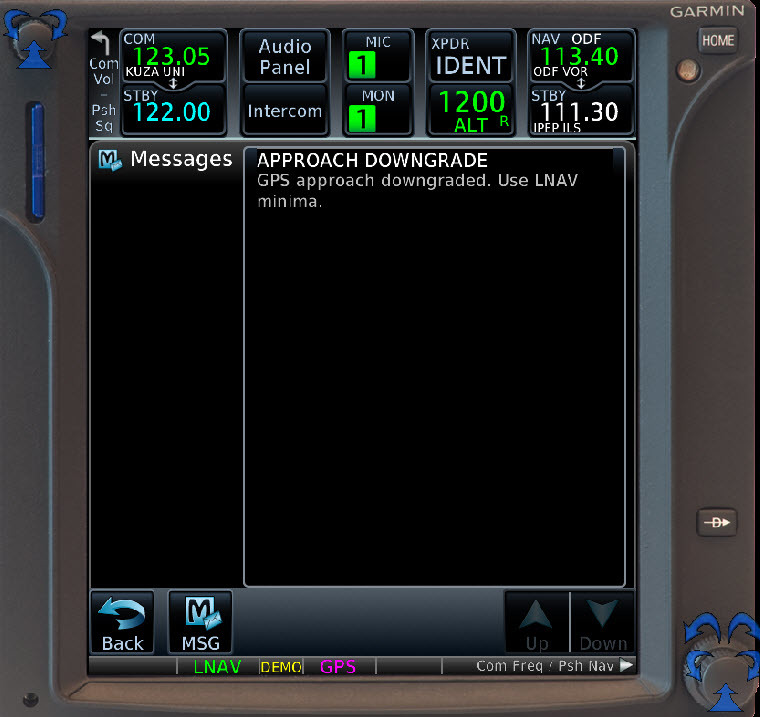
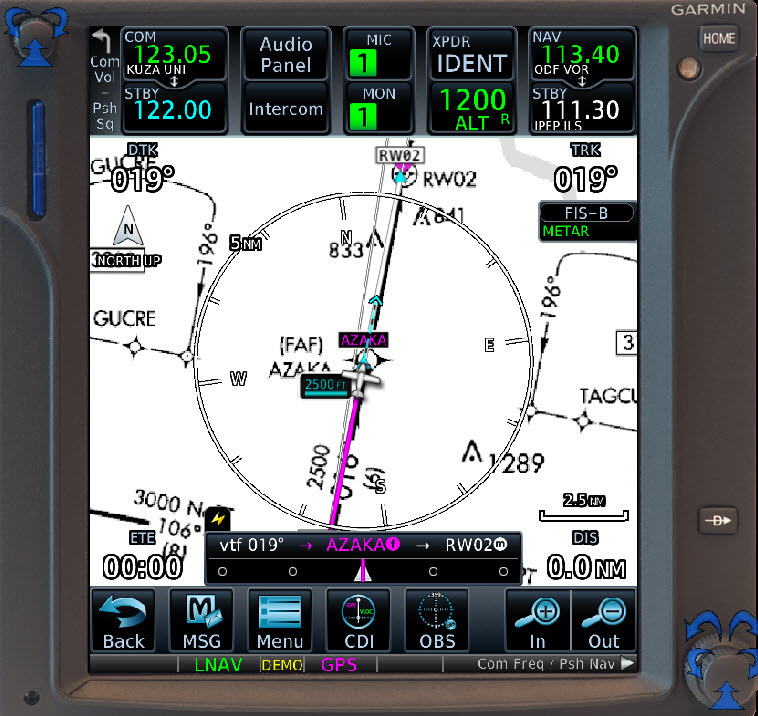
The approach entry in the GNS database will dictate the required accuracy and only one will be coded. So if an approach includes LPV, LNAV/VNAV, and LNAV options, LPV is coded and annunciated as long as the procedure does not fall back to LNAV. If the approach options include LNAV/VNAV and LNAV, LNAV/VNAV is annunciated as long as the procedure does not fall back to LNAV. There is no fall back from LPV to LNAV/VNAV. All fall backs are to LNAV and the vertical CDI will be flagged. The fall back occurs if it is going to occur at 1 minute before reaching the FAF. Prior to the fall back, the annunciation on the GNS is likely to be displayed in amber rather than the normal green.
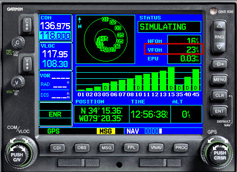
The fall back is based on the HPL (Horizontal Protection Level) and VPL (Vertical Protection Level) not meeting the minimum values for the approach. VPL and HPL are the 5 sigma containment radius for the actual position 99.99999%.. For all practical purposes, only VPL is relevant. A VPL of 50 meters is required for vertical guidance on an LPV with a DH >= 250 feet or any LNAV/VNAV. For an LPV with a DH < 250 feet, a VPL of 35 meters is required. Unfortunately VPL is not displayed on any screen in the GNS430W/530W, but on the satellite page, VFOM (Vertical Figure of Merit) is displayed. VFOM is an indication of accuracy in feet (the two sigma accuracy radius – 95%) and related in most cases to VPL and can be used to estimate VPL. A VFOM of 60 feet is indicative of a VPL of 50 meters and a VFOM of 40 feet is indicative of a VPL of 35 meters. So if you check the current value of VFOM as you near the destination, a value less than 60 feet says you will most likely get LPV or LNAV/VNAV annunciated and won’t get a fall back to LNAV. 60 or higher and there is a great likelihood of a fall back to LNAV. If you get to fly an LPV with a DH below 250 feet, then a VFOM less than 40 feet is predictive you will get LPV annunciated.
As far as HPL is concerned, for any LPV, it must be less than 40 meters. For LNAV/VNAV or LNAV, it must be less than 556 meters. Because of geometry, typical values of VPL are 50% higher than HPL at the same place and time. So the VPL of 50 meters is exceeded more often than HPL of 40 meters. Extremely rarely does HPL get close to the limit of 556 meters, so it is as close to a sure thing as one can get.
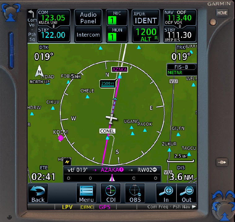
I attached some screenshots of the simulators for GNS530W and GTN750 to illustrate at my airport KUZA using RNAV (GPS) Rwy 2. I could not vary the simulated VPL on the GNS simulator but could on the GTN trainer to show the various indications, They are the same for both devices in real life.
530W showing VFOM
GTN750 with VPL and VFOM high value, note LPV annunciation
Message at 1 minute prior to FAF
Fall back to LNAV
F70100 wrote:
I’m bringing myself up to date with PBN and have a question that I can’t seem to resolve.If I understand this correctly, both LPV and LNAV/VNAV approaches are 3D and, with TSO-C146 (SBAS) receivers, the CDI provides guidance in an “ILS” like way both horizontally and vertically.
My question is, when both LPV and LNAV/VNAV minima are available for the same runway, how do you know in advance which annunciation, LPV or L/VNAV (and therefore type of approach) you expect to be displayed? I want to know in advance so I can brief and set the minima accordingly.
Ta in anticipation…
If you have an LPV box, you will get LPV. Should accuracy not be good enough, it will downgrade to LNAV.
How frequently does this LPV to LNAV downgrade happen in Europe?
Is there significant geographical variation in likelihood of such a downgrade?
Is it also dependent on age and quality of aircraft equipment and installations? For instance, does it happen more often to old/obsolete GPS boxes like GNS (think Windows 98) and the older GTNs (think Windows Vista)?
I would expect downgrades to LNAV to be relatively rare. Most likely is LPV200 because it has a tighter VPL maximum of 35 meters. LPV services are affected by solar storms. Yes, the coverage fringes tend to have poorer performance, in the US like Alaska and the west coast because of a lack of ground stations in the Pacific Ocean, but even on the west coast, the service is highly available, in the 99+ % area. I have never experienced an outage in my area of the US, which is in the south east. I have noted a few outages during some bad solar storm events, but even that has gotten better with improved WAAS system software, There was one system wide outage since 2003 that lasted 4 hours where a software update to the system crashed WAAS, but the basic LNAV service without WAAS was not interrupted. We also had one of the two Geo satellites that provide WAAS go rogue and the ground lost control of it for over a year. The satellited drifted eastward and some parts of Alaska lost service. The satellite eventually lost orientation to the sun and when the batteries died, the system reset and control of the satellite was reestablished, but it took many months to get it back in orbit where it needed to be. Now there are three Geo satellites providing WAAS service and replacements are scheduled, so even if one goes OOS they are backed up.
Service is not dependent on the age of the navigator, but it is dependent on the software version of the navigator and in some old installations, the antenna.
Here are some sites for the US LPV performance:
https://www.nstb.tc.faa.gov/AirportOutages/
https://www.nstb.tc.faa.gov/RT_VerticalProtectionLevel.htm
Use this site for EGNOS:
https://egnos-user-support.essp-sas.eu/new_egnos_ops/aviation-portal/aviation-dashboard
Jacko wrote:
How frequently does this LPV to LNAV downgrade happen in Europe?
Very rare, even on old installations.
At our local airport, I have never experienced an outage of our LPV200, but there have been weeks at a time where the ILS GS was out of service to the same runway. As a practical matter, my experience is that LPV is more reliable than ILS and I only do ILS for practice since 2008.
ILS reliability is basically according to how they look after it, because the installation is dual-redundant so a single failure should not take it out.
A lot of airports, not using it much except perhaps for IR training, are running their navaids on a minimal basis…
Interesting that LPV will never degrade to LNAV/VNAV. Is there no way to force it manually? Presumably +V is lost also.
At our airport the ILS was an older system installed in 1997 and the vendor was no longer in business. During electrical storms, it is subject to lightning and loss of electrical power. At a non towered airport that does not serve the airlines, often the airport owner is responsible for maintenance and they contract out for that. So an outage can last several days before it gets looked at and then if parts are not available, even longer. The ILS has recently been replaced with a more current vendor, but if power is lost at the airport, there are no generators that kick in to power lights and other stuff. With LPV, one only needs to have power on board the aircraft, but a night landing might be pretty tricky.
The TSO doesn’t preclude downgrade from LPV to LNAV/VNAV using WAAS for the vertical guidance, but as a practical matter, the conditions that would cause a downgrade from regular LPV to LNAV/VNAV to occur is not practical, which would be that HPL > 40 meters yet VPL < 50 meters. LPV200 might have a greater possibility, because VPL would have to be > 35 meters but < 50 meters. HPL is not much of an issue for downgrade as LNAV/VNAV has the same HPL criteria as LNAV, its just that if HPL > than 40 meters, it is extremely unlikely that VPL is < 50 meters. It is so much more pragmatic to just say downgrades are always to LNAV and vertical CDI is flagged. If vertical guidance is available via Baro VNAV, then it would make sense in that instance for a FMS that also supported LPV to downgrade to LNAV/VNAV.


