
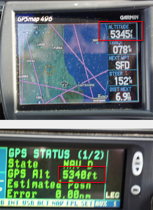
This is not a one-off… I usually see no more than 10-20ft between them.
This is very good news, but begs a few questions:
Did you verify EGNOS satellite to be in view at that time?
Do the two values also coincide so well on the ground in the vicinity of obstacles?
Is there any difference in the fluctuations of the two values on the scale of tens of seconds, especially in the first several minutes after power-up?
Yes.
Yes, as far as I can tell, within 10-20ft always.
It takes a while to settle after startup, with the KLN94 taking longer than the G496.
It takes a while to settle after startup, with the KLN94 taking longer than the G496.
I never tried these two, but every GPS receiver I tried (not necessarily aeronautical) took at least several minutes to settle, and the measured altitude always drifted downwards after startup, sometimes by as much as 150-200 ft. Do you observe the same?
Yes, probably a few minutes. But I am watching some other stuff during that time (waiting for the SG102 AHRS to settle, etc). Then I have ~10 mins from start of taxi to takeoff.
It’s notable how good the KLN94 is considering its crappy mid-1990s GPS receiver (a 3rd party module they bought in).
I have the GNS2000.
EGKK (up the road) says QNH is 1016.
The altimeter (KEA130A, USD 3000) is freshly overhauled.
I set 1016 on it. It says I am at 180ft.
The EGNOS GPS says 280ft.
If I set “geoid correction” on the app (Oziexplorer) it says 130ft.
So all of this is way off.
Surely an EGNOS GPS should not need the geoid correction?
That said, there is no obvious way to tell if the GNS2000 is receiving EGNOS… but even then this error does not make sense.
So exactly what is the altitude value that is represented by the GPS in question? Is it with respect to WGS84? If so, you would need to apply the local geoid correction. For example, ADS-B broadcasts what it calls the geometric altitude which is a value with respect to WGS084 and with a precision of 25 feet. To compare it with a corrected GPS altitude that would be displayed on a GNS430W on the terrain view, one needs to add the geoid correction to the WGS84 value and they should match each other withing 25 feet.
In addition to that, I wouldn’t bet on QNH at EGKK being the same as on the coast.
QNH is a rounded-down figure so the actual QNH could be 1016.9; you could immediately have a 25-30’ error.
Google says I live at 230ft. So that altimeter is within 1mb.


