Menu Sign In Contact FAQ
Banner
Welcome to our forums

ForeFlight (merged thread)

Correct. Right now, we are able to tell that the price hasn’t changed so we don’t touch it and only update the new price.

It could do a better job though of explaining so we already have plans for future updates so the feedback has been added to our request list.

Josh

ForeFlight - Head of International Gr...
KGTU, United States

Josh_Tahmasebi_ForeFlight wrote:

I know what you’re referring to with labels not showing until you zoom in further. Right now there is a space coefficient that I can’t adjust (I work on the Aero map personally), but I have this on my list and I’ll talk to the team about it next week and see if there are any quick fixes that can be made. I can’t promise it will be, but we will take a look. Peaks too :)

Hi Josh,

Is there any progress you were able to make on these improvements? These continue to be two of the main safety-diminishing issues in my opinion, i.e. you can’t trust knowing which potentially controlled airspace is ahead of you or around you when you need to look at that quickly and whether there is any major terrain to watch out for.

Thanks

EGTF, EGLK, United Kingdom

Hi @wbardorf,

I don’t have an update for you on it, but I will bring it up with the team again. When I brought it up previously, we did determine that the adjustment needed airspace labels is not a quick fix, however, we have some ideas on how to improve it. We do have a plan for terrain and will need to test to see what effect it may have globally.
I don’t have a timeline to share when these improvements currently, but the concern is definitely noted.

All the best,
Josh

ForeFlight - Head of International Gr...
KGTU, United States

Hi Josh,

Now (since Garmin Pilot software version 10) that Garmin has broken their own flight plan transfers via Connext, I’m wondering whether Foreflight has solved the problems with VRPs which we discussed here (post # 469).

Do you know if that issue has been fixed? Do Foreflight flight plans transfer reliably to a GTN now?

Specifically, would the route shown below transfer correctly from Foreflight to a GTN navigator? From Garmin Pilot 10.x it doesn’t (the departure aerodrome, Kirkbride, is unrecognised and “locked”). From previous versions of GP it would work. As of February last year, the VRP waypoint would not transfer from Foreflight.
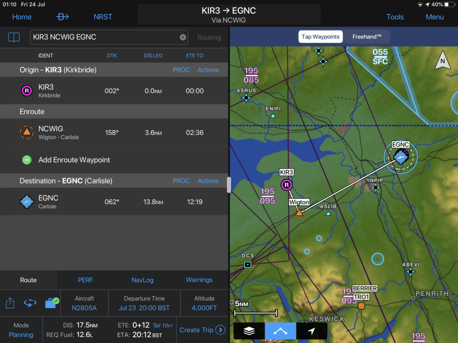
Last Edited by Jacko at 24 Jul 00:22
Glenswinton, SW Scotland, United Kingdom

Hi @Jacko,

Apologies for the delay. I have checked with the team on this to see where they are. On VRPs, this is in work, but not available as of yet. I pushed this up in priority with the team involved though so I expect this to be resolved soon.

On the airport in you mentioned, with this particular example, we are also locked. We have some work to do to update our system to better support airports where they do not have codes and an internal code was given for the airport. For instance, Kirkbride has a specific code in Garmin and one in ForeFlight to ensure we can show it in our system (e.g. EG37). We are working on updates here as well, but I don’t have a timeline for this yet either.

I know this is not what you were hoping to hear here, but all the questions have helped to renew the priority of the work and we should have a fix soon.

All the best,
Josh

ForeFlight - Head of International Gr...
KGTU, United States

Hi All,

I know I’m late here, but wanted to share the most recent updates from the last ForeFlight Mobile release 12.6:

Weather in Profile View

  • Enhance your route planning with a cross-sectional view of icing and turbulence forecasts displayed in Profile View.
  • Tap the new Layer Selector in the lower-left of the Profile window to choose between US or Global Icing and Turbulence layers like on the overhead map. You can enable one Icing layer and one Turbulence layer at a time, and also toggle the display of airspace in Profile.
  • Profile View uses the same color scales as the overhead map to depict varying intensities for each layer – blue for icing, green/orange for turbulence – at multiple altitudes in relation to your route line.
  • ForeFlight uses your planned departure and enroute times to display weather over multiple forecast periods during which your flight will be active, providing a more accurate picture of changing conditions throughout your flight. If no forecast data is available for all or part of your route, Profile shows hatch lines to indicate the lack of data.
  • Use the Ruler in conjunction with Profile View to “scan” along the map and see how weather for the current forecast period changes as you move the Ruler. Profile View has been optimized to render these changes at a much higher framerate than before, smoothly animating the cross-section of weather, terrain, and airspace.
  • ForeFlight will display Icing and Turbulence forecasts in Profile during a flight if you used Pack to download the data while connected to the internet. Profile does not support ADS-B Icing and Turbulence or other weather layers.
  • Weather in Profile View is available with ForeFlight’s Performance Plus and Business Performance subscription plans.

Overheat Alerts

  • ForeFlight warns you if your iPad or iPhone is in danger of overheating with a prominent visual and audible alert, allowing you to take steps to cool the device and potentially avert a shutdown during a flight.
  • The alert is triggered when ForeFlight detects that your device is dangerously hot and at risk of overheating and shutting down. However, your iPad or iPhone may still overheat and shut down before ForeFlight can display the alert.
  • Removing the iPad or iPhone from direct sunlight and turning an air vent towards it are the best ways to quickly cool it down.
  • The alert will not sound more than once per hour, even if your device returns to a high temperature state after initially cooling down.
  • You can disable these alerts in More > Settings > Alerts.

Additional Internet Traffic Details

  • Tap on Internet Traffic targets to see details about their filed routes and more.
  • When viewing Internet Traffic, tap on any aircraft marker to view a popup with information about it, including tail number or call sign, altitude, speed, aircraft type, and more.
  • If an aircraft is using a call sign, the popup will show its expanded name in most cases.
  • The popups for most aircraft on IFR flight plans also show the departure and destination airports and filed ETA, while many aircraft on VFR flights provide only the departure airport. Some traffic targets provide no route details.
  • Internet Traffic targets with blocked tail numbers will not report any route or call sign information.

New Mountain Peak Icons in High Resolution Basemap

  • The global High Resolution Basemap now shows the location of mountain peaks using a small triangle icon, along with each peak’s elevation in feet.
  • Enable the High Resolution Basemap for a particular region in More > Downloads > Download Settings.

More to come!

Best regards,
Josh

Last Edited by Josh_Tahmasebi_ForeFlight at 17 Aug 15:50
ForeFlight - Head of International Gr...
KGTU, United States

Hi Josh,

Thank you very much for the update on VRPs and small airports. My GP subscription has almost a year to run, so I’ll check back next spring.

Peter.

Glenswinton, SW Scotland, United Kingdom

Josh – quick one – is there a way to extract the European Foreflight/Jeppesen navdata to use in my EFIS which only accepts Jeppesen navdata? I’d like to avoid buying the same data twice, obviously. Thanks!

Fly more.
LSGY, Switzerland

Hi @Eurogaguest1980,

Thanks for reaching out. Are you thinking to use this to update the data on the EFIS? If so, we don’t have a way to do that, unfortunately. You would still need to purchase the data subscription from Jeppesen or your EFIS manufacturer (if they sell the data).

All the best,
Josh

ForeFlight - Head of International Gr...
KGTU, United States

Hi everyone!

It’s ForeFlight Release day again. Before I list what was added to ForeFlight Mobile, I wanted to mention that GAFOR and Internet Traffic have both been added to plan.foreflight.com as of late last week.

Here are the release notes for what is in ForeFlight Mobile 12.7:

Weather in 3D Preview

  • View interactive Icing and Turbulence forecasts as you play through your planned route in 3D.
  • Enable U.S. or Global Icing and Turbulence layers using the new layer selector in 3D Preview to display forecast weather along your route, and use the altitude slider on the right to view weather at different altitudes.
  • Tap the RTE button at the top of the altitude slider to only show weather at the same altitude as your route.
  • 3D View depicts forecast weather as floating colored blocks that use the same color scale to represent forecast severity as the overhead map and Profile View.
  • 3D View’s information panel in the top-left also indicates the forecast severity level at your current location and altitude, and adds a clock to indicate the estimated passing time at that location.
  • Like Profile View, 3D Preview combines multiple forecast periods to always show the actual forecast at every point along your route based on passing times.
  • Additionally, you can now show or hide the list of waypoints in 3D Preview by tapping the Route button in the top-right.
  • Weather in 3D Preview is included in ForeFlight Performance Plus and Business Performance plans.

Visual Approaches with TPA

  • Specify the pattern altitude for a new visual approach or traffic pattern entry in Procedure Advisor to add a prominent waypoint with the TPA in your route.
  • Access visual approaches in Procedure Advisor’s Traffic Pattern or Approaches menu.
  • Enter a custom traffic pattern altitude in either MSL or AGL formats, or tap the Select button to choose from a list of recommended pattern altitudes.
  • Select the type of traffic pattern entry or a straight in approach and tap Add to Route to insert the pattern entry with marked TPA waypoint into your route.
  • Tap the pattern entry in the FPL Bubble Editor and tap Set Pattern Altitude to change the selected altitude and update the TPA waypoint.

Internet Traffic Search

  • Find active Internet Traffic targets anywhere in the world by typing a tail number or call sign into the Search bar.
  • You must have an internet connection and be on the ground to search for Internet Traffic. Searching for aircraft while connected to an ADS-B In receiver will only show traffic targets received by that device.
  • ForeFlight displays matches for partial and complete search terms under an “Internet Traffic” header in the Search results list.
  • Tap on any traffic result to reposition the map and highlight the aircraft, which will also enable the Traffic layer if it isn’t already.

FBO Detail View Enhancements

  • The FBO detail view now displays self- and full-service fuel prices for both 100LL and Jet-A or Jet-A+ in a more compact table.
  • Information about contract Jet-A pricing via your JetFuelX fuel cards is also now available above the retail fuel prices at the top of the Information tab, rather than in a separate tab. Integrating your JetFuelX fuel cards into ForeFlight is available with ForeFlight Performance plans.

For more information, please check out https://www.foreflight.com/releases/12-7

Have a good evening everyone!

Josh

ForeFlight - Head of International Gr...
KGTU, United States
Sign in to add your message

Back to Top