I think if you set up Foreflight downloads like this, you can download anything you want, any time you want, without incurring unwanted cellular data costs.
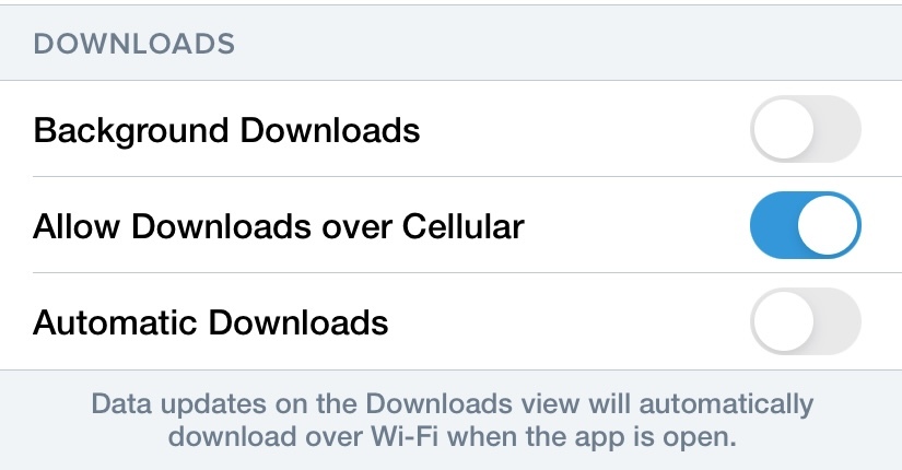
Good point; I will try that. It sounds like that setting will go online only for specific items downloaded.
Peter,
The setting affects the downloads at More>Downloads. Which files are selected for download are specified in your download settings and the list of files in your download section. Data such as NOTAMs, Fuel Prices, Winds Aloft and anything not included in the downloads tab are not affected by the setting.
Finally the profile view supports displaying different altitudes!!
This was a long awaited feature and I got it in with today’s update. Good for VFR in messy airspace.
it seems to be available only for pro plus subscriptions and higher, though.
ForeFlight 14.4 is published.
Per-Leg Altitude in Profile
Easily plan enroute altitude changes around terrain, weather, or airspace and visualize them in Profile View, with the option to start or end a climb or descent at a specified waypoint. To plan an altitude change at a specific waypoint, tap the waypoint’s bubble in the FPL Route Editor and tap Set Altitude/Speed/Time, or tap the waypoint’s label in Profile View. Available with Pro Plus subscriptions and above.
Available with Pro Plus subscriptions and above.

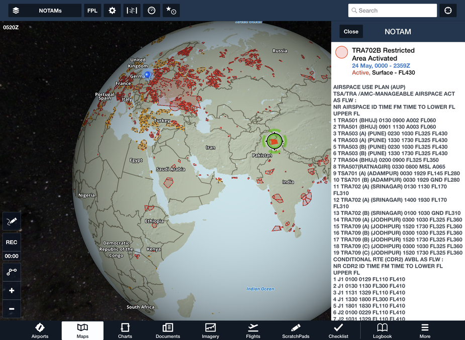
Global Graphical NOTAMs
Previously limited to Europe, Graphical enroute NOTAMs are now supported globally with the new NOTAMs map layer. NOTAMs are color-coded red, yellow, or gray based on type, severity, and active times.
Additionally, with the NOTAMs layer enabled, you can selectively filter which types are shown using the new menu in Map Settings > NOTAMs Settings, with toggles for Exercises, Controlled Airspaces, Obstacles, and Other.
Distance Rings and Altitude instruments in Kilometers
Easily gauge the distance to your surroundings in kilometers with a new Distance Rings setting. Enable Distance Rings in Map Settings > Distance Rings, and tap any of the three labels attached to Distance Rings to change to kilometers.
Customize the units of altitude displayed by the Map’s Instrument Panel for inflight reference with the new Altitude Instruments menu, available in More > Settings > Units/Time.

At last!
Anybody know why autorouter.aero appears to be more agile than FF in providing routes? FF tends to provide a lot of invalid route suggestions and only around 50% of the time will the selection have a valid route, or a route with a level which doesn’t require oxygen (assuming MEA is low enough in the first place). I basically have to check both autorouter.aero and FF to get a route, which is OK but can be a bit tedious.
In a previous job I used Rocket Route which did what it says on the tin and would generate valid routes very quickly, albeit at FL240 and above.
Perhaps this is a piston GA problem, but I would have thought the programs use similar algorithms for dealing with eurocontrol?
How do people download charts, and organise their downloaded charts?
I’ve had the EGKA RNP 02 and RNP20 because that’s all I need for my base.
I know how to send a chart to the map so I can see the plane on top of it, and how to vary the chart opacity against the base map.
The other day I downloaded the LFRD (Dinard) charts for a trip. I looked everywhere but the impenetrable FF UI did not reveal to me how I can just download all LFRD charts  So I downloaded them manually, one by one.
Today I went to EGJB (Guernsey). Could not find a way to delete the LFRD ones, except one by one, which is ridiculous if true. Try that with Charles de Gaulle Then downloaded the EGJB ones, but when I went to access them they were all missing, even though I had “packed” them… I landed on ILS09 (obviously it doesn’t need them to fly, and I have an old, 2019, set of Jepps for all of Europe, as PDFs, in case of emergency, on my phone). Before departing back home, I managed to download the airport chart and the only likely SID, and that worked, but again no way to download all EGJB charts in one go.
The FF UI continues to baffle me at every step, beyond using the moving map, selecting chart types, and I even worked out how to enter a route. Always takes me a while to find how to delete a route though
And I fly once a week, which is more than most people.
Maybe the Ipad Mini UI is screwed up, but I can’t fly with anything bigger.
Do you have your route saved on the Flights tab? If you select a flight on the flights tab and click on the “send to” icon at the top, besides sending the route to the map page, you can also send it to plates. That creates a binder for the flight on the charts tab with all the charts. You can then select the individual charts as you need them, or if you want you can select only those that you want to use and then you can swipe from one to the next using 3 fingers and only those selected will be presented.
My conclusion after having tried out FF a couple of times is that the big flaw with the user interface is that it is highly modal, i.e. it operates in different modes where you do different things. It has been known since the 1980 at least that modal UIs are harder to use than nonmodal ones. Of course, all UIs are modal to some extent (e.g. popup windows), but FF really depends on this. To plan a flight you have to do different things in different modes – and in the right order!
In contrast, SkyDemon really only has two modes: planning and flight. Even though this annoys me sometimes it does correspond to two essentially different operating situations.
I’m sure that if you only look at what it can do, FF is great, but its UI is not.