
Xlr8tr wrote:
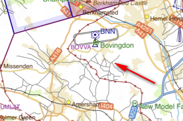
two images of the same busy area, both programs have all the ‘cultural elements’ turned on.
To be honest, I don’t think that the SD map is good enough for VFR map navigation either. If you navigate solely by GPS, then the FF map would do fine.
If you navigate solely by GPS, then the FF map would do fine.
I agree.
If you fly by ground features (which almost nobody does nowadays) then you will probably be using something like 1:250k charts (the UK does those, specially for that purpose) and IMHO that’s not a market worth pursuing because getting hold of that detail in a machine readable format means throwing yet more money at copyright owners. This sort of detail is really pointless
What is needed for VFR flight is a very clear airspace depiction, with properly done merging of the polygons, and audio warnings of airspace busts coming out via the device’s audio output (3.5mm and bluetooth) are especially key in the UK due to the new CAA 100%-bust-them policy 
Interesting to see the different diameter of this area, between the two programs
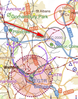
It is known that the UK CAA charts, and the UK AIP, show certain danger areas significantly bigger than the byelaw which defines them  Probably not much a nav app developer can do about that since they have to obey the AIP, but this difference is worth investigating in case it is something else.
Airborne_Again
To be honest, I don’t think that the SD map is good enough for VFR map navigation either. If you navigate solely by GPS, then the FF map would do fine.
If you’re navigating solely by GPS then surely you aren’t using the map at all, other than to check you programmed your GPS correctly.
I’d be interested to hear why you think the SD map isn’t suitable for VFR navigation.
Peter 27-Mar-20 14:15
If you fly by ground features (which almost nobody does nowadays) then you will probably be using something like 1:250k charts (the UK does those, specially for that purpose) and IMHO that’s not a market worth pursuing because getting hold of that detail in a machine readable format means throwing yet more money at copyright owners. This sort of detail is really pointless
The object of the exercise was to show Josh just what detail is available as a selectable (declutter-able) vector, not what I’d necessarily have displayed during a flight.
Having said that when I’m flying open cockpit or tandem tailwheel, single radio, 60-80 kts I very much appreciate that level of detail around busy airspace. Why would I want a folded 1:250k chart taking up valuable space when I can have so much more information on my phone/tablet. When I’m in my Cirrus I declutter to what I think I need and when at the day job (B777) I declutter even further.
This thread is full of posts stating that Foreflight isn’t yet usable for VFR in Europe, I’m trying to give some feedback as to why I think that is the case, me, myself, I – the way I would use it, the information I would need to make it my one stop shop.
Both apps are highly customisable and you can choose how or what you want to display, if that information isn’t there in the first place however then it becomes a little more difficult.
Xlr8tr wrote:
If you’re navigating solely by GPS then surely you aren’t using the map at all, other than to check you programmed your GPS correctly.
For airspace awareness (to avoid it or to ask for clearance), to avoid danger/forbidden areas, etc.
Based on speaking to countless people, I think most CAS busts are caused by a distraction, not by the pilot having misread the map during planning. That aspect of any app used for VFR needs to be seamless and totally reliable.
lionel 27-Mar-20 15:24 178
Xlr8tr wrote:
If you’re navigating solely by GPS then surely you aren’t using the map at all, other than to check you programmed your GPS correctly.
For airspace awareness (to avoid it or to ask for clearance), to avoid danger/forbidden areas, etc.
Yes I know, I wasn’t the one who said “navigating solely by GPS”
Peter 27-Mar-20 15:31 179
Based on speaking to countless people, I think most CAS busts are caused by a distraction, not by the pilot having misread the map during planning. That aspect of any app used for VFR needs to be seamless and totally reliable.
Not sure what you’re getting at here Peter, I agree distraction management is indeed hugely important when flying. In what way are you thinking it applies to these apps?
I’ve never been able to understand why British pilots love these ridiculously cluttered maps. Always preferred the Jepp ones when I lived in the UK.
It’s all we have ever had.
There are others e.g. Air Million but they have never achieved much market penetration, presumably because most UK PPLs think they are “not official”
However a lot of non UK airspace (e.g. French, as depicted on SIA or IGN) is even worse. The UK CAA charts are at least unambiguous at all points (except Belfast; another discussion).
Xlr8tr wrote:
I’d be interested to hear why you think the SD map isn’t suitable for VFR navigation.
There isn’t enough detail of ground features. I do a reasonable amount of “pure” VFR navigation in the Swedish Voluntary Air Corps. SD maps aren’t nearly detailed enough — we always use 1:250000 charts. (Except when flying at 200 ft AGL — then we use military 1:100000 charts but that’s another story.)
Don’t get me wrong — I love SD and have used it for 7 years, but I won’t use the SD maps for navigation unless I have GPS.


