Menu Sign In Contact FAQ
Banner
Welcome to our forums

ForeFlight (merged thread)

Hello everyone,

We have another release to share with 11.6. Here are the release notes. For more information, visit https://foreflight.com/releases/11-6/

Expanded Coverage for Estonia, Latvia, Lithuania, Belarus, and Ukraine

  • All European subscribers can now download AIPs for Estonia, Latvia, Lithuania, Belarus, and Ukraine, which include IFR High and Low enroute charts, IFR procedure charts, and documents for all five countries, as well as VFR procedure charts for all countries except Ukraine, and integrated Jeppesen VFR data for Estonia, Latvia, and Lithuania.
  • Visit foreflight.com/europe/data to learn more about what data is available for Europe and compare coverage for different countries.

General Aviation Forecasts (GAFOR)

  • Plan your flights with a new graphical GAFOR depiction covering France, Germany, Switzerland, Austria, Slovenia, and Croatia.
  • GAFOR regions and routes provide color-coded indicators of each day’s forecasts. Tap on each indicator for additional details about each forecast period, such as the reference altitude, GAFOR index, cloud base, visibility, and specific weather phenomena.
  • ForeFlight saves the latest GAFOR data when you Pack for a flight so you can access it without an internet connection.

3D Review

  • Follow the path of a planned or recorded flight, with high-resolution terrain and aerial imagery providing an interactive replay so you can get the view from altitude.
  • Preview planned flights from the Maps or Flights views, and replay past flights from Track Logs or Logbook entries, complete with realistic pitch and bank if you recorded the flight with an AHRS-capable device.
  • Manually scrub through a flight using the built-in timeline, or auto-play the flight at 1x, 3x, 5x, 10x, or 20x normal speed for a faster overview.
  • Pan and zoom within the interactive 3D View to get a 360° panorama of the environment along a route.
  • 3D Review is included in ForeFlight Performance plans.

Map Annotations

  • Write and draw directly on the Maps view for easier note-taking on the fly.
  • Tap the new Annotations button on the left sidebar to enter Drawing Mode.
  • Use one finger to draw, and use two fingers to move the map without adding new annotations.
  • Editing options include choosing line color, opacity, and thickness, and you can undo, redo or clear all annotations.
  • Quickly add Map Annotations by touching your Apple Pencil to your iPad’s screen, while normal touch gestures still allow you to pan, zoom, or tap on map objects. Auto Apple Pencil Drawing mode will automatically exit after 10 seconds without input.
  • Enable the Auto Apple Pencil Drawing setting and change or disable the Drawing Mode Reset time in More > Settings.

Checklist Speak

  • Complete your checklists more efficiently by allowing ForeFlight to speak them to you.
  • Tap the “Speak” button when viewing a checklist and ForeFlight will read each challenge item, or both challenge and response, aloud.
  • A quick-action bar at the bottom of the screen allows you to pause or exit Speak mode, and move faster or slower through the checklist. This bar remains visible on every app view so you can continue using other parts of the app while running through the checklist.
  • Access settings for Checklist Speak in More > Settings.

Alternate Airports Included in Pack

  • The Pack feature on the Flights view now includes airport, weather, and chart information between your destination and your selected Alternate.
ForeFlight - Head of International Gr...
KGTU, United States

It’s nice that we got Belarus and Ukraine although I somehow doubt that these two countries are of much interest for ordinary European GA pilot. Adding Serbia and Montenegro (just few airports in AIP – actually 4 real airports in these two countries) and Northern Macedonia (only 2 airports) would be much more useful.

LDZA LDVA, Croatia

I am waiting for fly by waypoints in route generation. Then I will renew my subscription which has just expired, and will get an ipad mini.

Administrator
Shoreham EGKA, United Kingdom

Funny thing yesterday ForeFlight continued to track me after landing when I was driving home. I hope traffic police doesn’t check EuroGA and won’t notice me driving 100 kts

LDZA LDVA, Croatia

Emir wrote:

It’s nice that we got Belarus and Ukraine although I somehow doubt that these two countries are of much interest for ordinary European GA pilot. Adding Serbia and Montenegro (just few airports in AIP – actually 4 real airports in these two countries) and Northern Macedonia (only 2 airports) would be much more useful.

Appreciate that Emir. We plan on having more released soon as we have released a batch of countries every month since October! 32 and counting.

Josh

ForeFlight - Head of International Gr...
KGTU, United States

Josh_Tahmasebi_ForeFlight wrote:

We plan on having more released soon as we have released a batch of countries every month since October!

You’re doing good job – I’m using georeferenced plates practically on every flight. Although it took some time to get used to AIP plates, at the end they increase situational awareness.

LDZA LDVA, Croatia

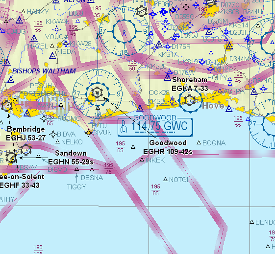
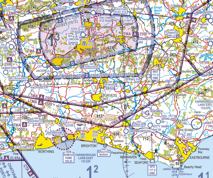
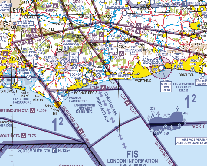
I’ve been looking again at FF and using it for VFR flight. The accurate depiction of CAS is then crucial.

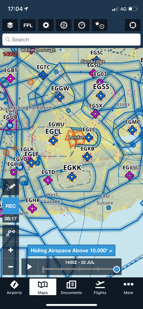
This is what appears for my local area (decluttered by not showing airspace above 10k feet):

I was curious what these lines were

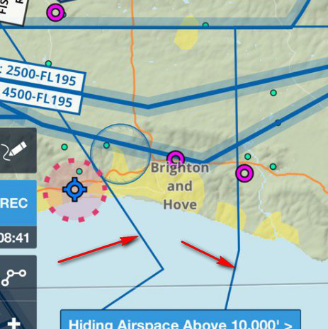
since they don’t appear on the 1:500k VFR chart (which shows airspace below FL195)

Zooming on on FF, one can see this

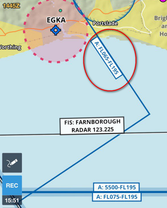
Can anyone tell me what this relates to?

Administrator
Shoreham EGKA, United Kingdom

This is was Jeppesen shows in that area.

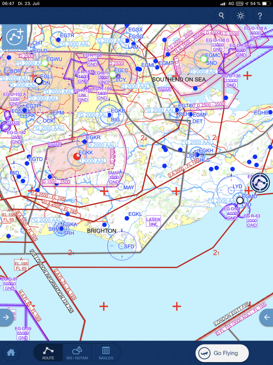
As Garmin shows the same pic as Jeppesen it looks like an important database failure of FF. That’s what I guess at the moment.

EDDS , Germany

Hi Peter,

Wolfgang here. Thank you for the report. Could you please send the screenshots and a short description to [email protected]? Our data team will take care of and correct the data. But first, they have to be aware of the issue.

Thank you,
Wolfgang

EDON, Germany

Wolfgang – will do.

Peter – that GP pic isn’t right either. See bottom left of your map

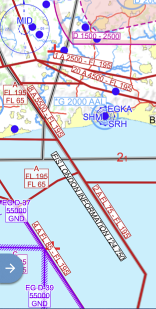
and compare with the CAA one

I think, in both cases, this is a failure of the declutter algorithm. Prob99 those shapes are in the database containing the airspace polygons. This is published, in the AIP I think. Lots of software has had problems with rendering this stuff in 3D.

I don’t have SD but EasyVFR shows it correctly

Jepp Flitestar (which probably nobody uses today – EuroVFR charts) shows it right

Administrator
Shoreham EGKA, United Kingdom
Sign in to add your message

Back to Top