I grew up by the sea, and how far you can see to the North and the South is a good measure of visibility. I remember a particularly fine evening two decades ago when we were sat on the seafront discussing the extraordinary view. From the North Wales mountains down to Brecon, everything was crisp as crisp as could be – we all agreed that none of us had ever seen it so clear before.
These days, it seems to me that I can often see that far up and down the coast. Air quality really seems to have improved. I didn’t fly 20 years ago, but I wonder whether other people also feel that visibility has got better. It certainly makes for more pleasant flying when you can see the view.
An interesting Q about the wx. We had a thread on this here before… people say that e.g. 20 years ago there was far less convective wx than today. Today’s jets end up in IMC at FL300 fairly often.
I wonder which ones?
Balkans comes to my mind  causing huge time-gap in my flying career.
I don’t remember many people from ex-Yu flying GA much internationally but flying to airshows and some contests was not so uncommon both to Western and Eastern countries.
Being glider pilot at that time (30+ years ago), I remember we were only obliged to switch to approach control frequencies of large airports if flying in their airspace and if flying above FL100.
Peter wrote:
people say that e.g. 20 years ago there was far less convective wx than today. Today’s jets end up in IMC at FL300 fairly often.
I am not so sure. In one way or the other, certainly the wx has changed. The other bit which has changed massively however is the way we observe weather. Even in the 15 years in which I work in this business, the change in technical means is stunning.
CB’s which go up to FL300 or above are not new. Nor are there more than before, in a general sense. There have been some trends in recent years that there is more convective weather in parts of Europe, mostly however, I personally think the main reason we have become more aware of certain weather events is that we can see them today, whereas we could not see them 30 years ago, nor was there the Internet with all its weather sites which brought the high res stuff to the general public.
I would classify the above statement as a myth. We had convective activity then, we have it now. At the time, I recall that there were talks of “tornadoes” but nobody could prove them, today we have “reader reporters” who will film everything and put it up the net. This has brought a lot of material to light which was simply not available at the time.
What has chanced is our perception and what we, as PPL’s, have access to. In the old days, you would call the met office, which had models available for 2-3 days ahead and did educated guessing for the days further ahead. Those educated guesses stemmed out of massive local and specific experience. We would talk to these guys and they would give us a briefing based on that experience. So we went off into the wild blue yonder on their advice, most of the time they were right, sometimes they were wrong.
Today very few people bother to ever call a meteorologist, because they feel that they see enough in todays elaborate sites. We think that we know the weather for 3 weeks ahead because Weather Pro or Weather Online said so and wonder why our dispatch rate is down. The rules of weather have not changed, only the way it is forecast. Today we have models which do claim to tell the weather for ridiculous amounts of time ahead and people believe these models, even though most of those sites work with the least specialized but free global models. The fact that the highly precise local models often deviate massively from the GFS data most weather sites use, is widely disregarded by many, as those model outputs are expensive to buy or even look at. And even if they are available, people do not know what to look for, but mostly rely on the little sunny or rainy symbols when planning ahead.
Meteorologists can however interpret this stuff and often can give much more to the point advice about the time ahead than unfiltered model outputs can. We often experience this when people have ended up rained in someplace and then finally call us for help… such as a prominent organisation’s Scandinavia flyout a few years back which ended with most folks stranded, abandoned airplanes and a lot of swearwords about the weather.
The added features are not only positive however. I have caught myself often enough calling off longer flights due to the miserable outlook for getting back when in the end it was not as bad as it initially looked. Even though post mortems mostly showed the trends were right, they were often not as extreme as predicted. So in the 1980ties, young and carefree, I’d take chances I no longer dare taking today, which has reduced my dispatch rate to a pretty absymal rate. Maybe not knowing and then reacting was better…
Mooney_Driver wrote:
The fact that the highly precise local models often deviate massively from the GFS data most weather sites use, is widely disregarded by many, as those model outputs are expensive to buy or even look at
Not even that. I’ve found the GFS models to be essentially useless. This is the GRAMET based on GFS data 25 hours before a flight I made yesterday:
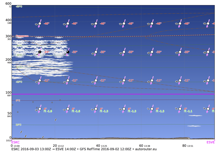
The GRAMET based on GFS data 13 hours before the flight looked like this:
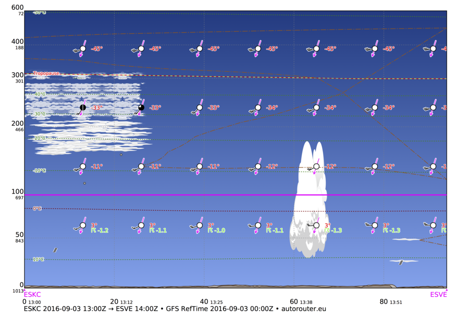
In reality, there were several SCT/BKN cloud layers starting at 2500 feet. Lots of CBs, RASH and the occasional TS. The Swedish MET Office had correctly predicted this several days in advance. Also if you looked at the UK MET office prognostic chars, you would have seen a low with front systems passing the area. I would expect that with 13 hours notice GFS would do a better job. Unfortunately, this is not at all unusual.
I’ve found the GFS models to be essentially useless
GFS is almost useless for forecasting stratified cloud, for sure.
It predicts a probability of buildups but mostly those are blindingly obvious from the MSLP charts.
There is a long way to go but the better models are all sold for money (in Europe) so we don’t get to see them.
I assumed air quality and visibility had improved simply due to catalytic converters and better environmental standards for industry. Just pleasing when you can see improvements rather than having to measure them.
Alas changes in climate/convectivity etc. are a whole other matter.
Good example Airborne, for what I am trying to say.
GFS is great for a lot of stuff as it is one of the models which are truely global. Therefore, GFS has the WHOLE picture, not just a part.
GFS winds are most of the time quite adequate for flight planning, I’ve used them extensively on long haul planning and they are more than adequate for that. They may be less so for short haul, particularly ultra-short haul flights (less than 100NM) as there clearly local models are better.
Stratiform clouds, GFS has not got nearly the resolution for that. Convection, sometimes, sometimes not, certainly not pin point as if in Eastborne yes, in Hastings no. GFS can give you a good general idea.
Yet countless weather apps are based mostly on GFS, because it’s free. So guess what happens: Weather forecasters who are sitting behind screens displaying expensive local models not available to the public to this extent are faced with “I need to know if it’s gonna rain in xxx in 3 weeks time at 1545.” If I tell them, forget forecasts like that, what I get back is “Oh,but my phone sais…”
But even looking at forecasts generated with the “pay for” data can be a bit hit and miss. For example, I had a 2.5 hr flight planned for the Bank Holiday Saturday, and the official UK Met Office forecast flipped at least four times a day in the 3 days running up to it from “easy flight with some minor shower dodging” to definite “no how no way”. The only forecast that reflected the weather we actually got was the forecast I downloaded while sitting at Area Mike at EGNS five minutes before I cranked up the engine (and by then much was known because I had actual observations for the route).