
I have send details by email.
what_next wrote:
We can’t know that. Maybe there were enough holes in the cloud cover during their descent. Maybe the clouds were layered and broken and gave them a good enough view at the terrain
Yes, that is true. But it is also true that below approximately 10k feet, the whole area is VFR only, except when following any eventual approach glideslopes. Reading the first post again, it looks like they did indeed switch to VFR sometime during the descent. If FR24 and the crash site and hitting the east slope is correct, this means they were cruising in and out of clouds, well below the mountain tops, with at least one 180 degree turn, looking for a hole in the cover. They were flying “IFR” in VFR-only airspace, where it was IMC (if it wasn’t, they would see the top they crashed into before it was too late), and they did this below mountain tops. They were taking an insanely huge risk, and it went bad. There are few other ways of looking at this IMO. If they took that risk on purpose, is maybe something we will never know. Regardless, a VFR app with terrain would probably have kept them alive, it’s the only thing that could, except some glass panel with the same functionality. Diverting this to a discussion about reliability of such an app on a pad, is irrelevant, hardly even of theoretical interest, given this particular situation. The moment they got below about 8000 feet, they could hit a mountain any second, which is exactly what they eventually did.
The other alternative is they were confused about alt and/or position. One of my first thought about this was that they planned to descend farther SW, in the flatlands SE of Lyon for instance, and continue VFR from there, maybe up from Grenoble or something, but got off track. Looking at all the airports etc in the area, and the fact that they flew IFR, this doesn’t seem very likely though, but who knows.
LeSving wrote:
If FR24 and the crash site and hitting the east slope is correct
“L’épave a été retrouvée dans une combe enneigée sur le versant Est du Mont Trélod, côté Savoie.”
LeSving wrote:
(if it wasn’t, they would see the top they crashed into before it was too late)
Not neccesasrily. Pilot have flown up valleys, seen the rising terrain, but still not managed to avoid it for various reasons in VMC.
The flight was at FL065 all the way from the location shown, to the very end of the track shown
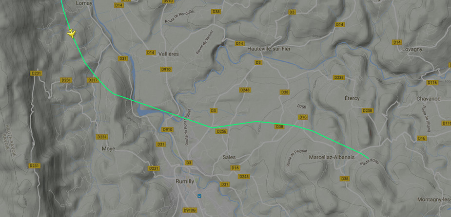
This shows the three relevant points
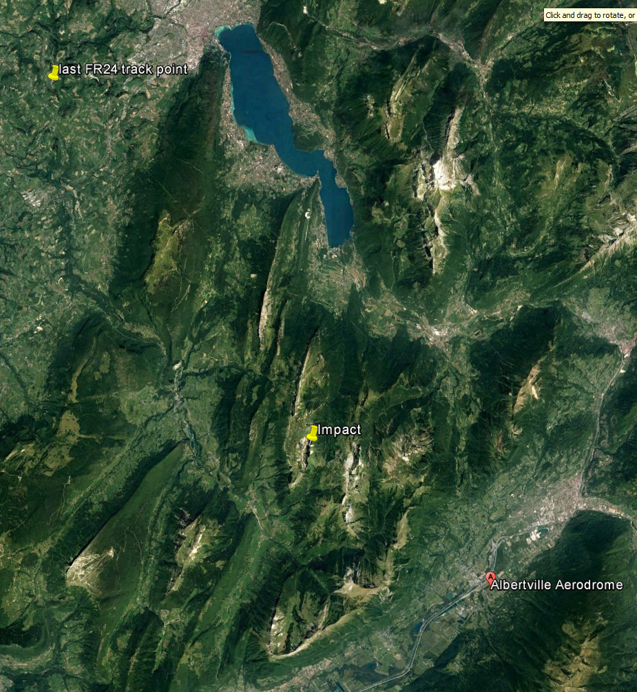
Still does not make much sense… which route were they flying to end up where they did after a turn back? neither of the mentioned ones in the valleys I reckon?
I hope they can read out the GPS track so we´ll eventually know. I really wonder how they could have ended up in this position.
Trelod peaks at about 7’200 feet and all the surrounding ridges are pretty high up – Arlicots, Arces, Armenaz, Arcalod and Sambuy peak betweem 6.8 and 7.2. So flying through cloud at anything lower than 7.5 is really asking for it. It’s already impressive that they got as far.
On the other hand if you have thoroughly briefed your VFR approach and route to alternate (which by Annecy especially given the cloud cover you should have had) you do not go lower than 7.5 unless strictly following the highway via Chambery or the RN through Ugine (but that valley is rather tight)…
The final FR24 data points for the flight, most recent at the top:
2016-11-25T13:30:12Z	DESPJ	45.873436,6.015415	6500	122	109
2016-11-25T13:30:06Z	DESPJ	45.874866,6.012255	6500	122	109
2016-11-25T13:30:00Z	DESPJ	45.879299,5.998393	6500	122	109
2016-11-25T13:29:42Z	DESPJ	45.8811,5.99303	        6500	131	93
2016-11-25T13:29:26Z	DESPJ	45.882641,5.985162	6500	131	93
2016-11-25T13:29:15Z	DESPJ	45.883644,5.97072	6499	143	98
2016-11-25T13:28:55Z	DESPJ	45.881931,5.953208	6400	143	98
2016-11-25T13:28:22Z	DESPJ	45.891354,5.913836	6400	119	139
2016-11-25T13:27:52Z	DESPJ	45.892857,5.911231	6400	119	139
2016-11-25T13:27:42Z	DESPJ	45.896622,5.906418	6400	119	143
2016-11-25T13:27:35Z	DESPJ	45.900215,5.902342	6500	119	151
2016-11-25T13:27:20Z	DESPJ	45.907887,5.897185	6499	116	162
2016-11-25T13:27:08Z	DESPJ	45.914207,5.894177	6500	117	165
2016-11-25T13:26:47Z	DESPJ	45.924488,5.890581	6699	113	191
2016-11-25T13:26:34Z	DESPJ	45.929829,5.890851	6800	113	191
2016-11-25T13:26:22Z	DESPJ	45.940861,5.896337	7000	116	206
2016-11-25T13:25:58Z	DESPJ	45.94643,5.899997	7100	116	206
2016-11-25T13:25:48Z	DESPJ	45.953827,5.906375	7300	120	215
2016-11-25T13:25:30Z	DESPJ	45.958508,5.911145	7300	120	223
So the final logged track was about 110.
That seems to be heading towards the middle of that big lake, and maybe the intention was to position to the NE of the airport and descend down the canyon and land.
The impact location would then suggest that a right 180 turn was made to turn back.
Yes of course they should have been flying higher, so why did they think 6500 was OK?
I have no idea which tablet product Stefan was using and I think probably none. He would have referenced a paper chart, IMHO. So, which one? The only one which is crappy enough to make somebody think 6500ft is OK is the French SIA one. The IGN and Bossy ones all have the spot elevations.
I did something similar in 2004, over France, but I descended through a layer in the SE of France (to turn left into Switzerland, towards Grenchen) and before much terrain, so I did it where the SIA chart did show some spot elevations. I would like to think I would not have done that descent had the chart not shown sufficient spot elevations, but it does make me wonder… Later over Switzerland I found the “cows too big” because of the stupid Swiss chart mixing metres and feet but by then I was VMC, else I might have been dead there too. We live and learn…
Yes, it seems this one event where a Human Factors lecture is also in order….
Peter wrote:
Later over Switzerland I found the “cows too big” because of the stupid Swiss chart mixing metres and feet but by then I was VMC
Peter you know Swiss charts have shown quadrantal MSA in feet for a few decades now :-)
In this specific case reading the map combined with a low(ering) ceiling one would think big straight valley = good, small meandering valley = really not good… especially if not familiar with the area. And this you’d do at the flight planning stage, not once you get there…
In general I would assume that when flying VFR between rocks one shouldn’t take any number for granted unless one is really sure what that number means. “I can’t be bothered to read the map / legend” is a bad line of defense if one lives to the court appearance…


