I flew in the general area at the same time and tops were maybe 7000ft. They may well have been higher where he was.
I never flew in Stefan’s plane but he told me he had an oxygen system. However I don’t think that would be an issue here because he could have flown at his FL130 cruise all the way to destination airport overhead and, if no cloud below, could have spiralled down, or some variation. At Locarno I would spiral down from FL150. At Zell, I descend from ~ FL130 down the canyon, about 20nm.
One relevant thing is that I don’t think he had any topographical representation anywhere. He had a KLN94+KMD550 (same as I have) and an Aspen EFD1000 (which failed 3 or 4 times, usually in IMC, as they used to do in their early days – he sent me photos showing the big cross across the screen). I don’t know if he had any GPWS and in any case you get constant spurious warnings from that when going to any place anywhere near mountains e.g. with Zell you get it constantly for about 10 minutes. The KMD550 has terrain colour coding but it is virtually useless; moreover the Jeppesen colour coding is wrong (per the pilot’s manual) and according to some emails I have from a US King dealer has been implicated in several US enroute CFITs – I am however certain he would have never used that and I never look at it except to see where the Alps are :)
This accident is a mystery. But they do happen…
I think lack of oxygen at flight level 130 could be an issue. I have been up that far and higher with an acclimated instructor gliding in the mountains, and at that level I had a headache and wanted lower. Definitely not at my best. That’s why I asked.
But it sounds like lack of topographical representation could be more to the point.
I am told the normal procedure here is (assuming you are on top), fly the ILS into Annecy or Chambery to get below the cloud base and then proceed via the valleys visually to Albertville.
I think regardless of the eventual reason here (and I doubt we will ever know), it is a useful reminder more that regardless of experience, aviation is unforgiving. There really have been a lot of these off airways IFR into VFR CFIT accidents over the past few years.
I talked to Stefans partner from his company. He told me the second pilot was from the aviation Club where both was members. But the accident is also mysterious for them. He knows meantime that they canceld IFR several miles west of the mountains. According FR24 they was at 6500ft. This is 200m higher than the Mont Trélod (2181m). But Aviation Safety writes they crashed into the eastern slope of Mont Trélod. This is strange. RIP Stefan.
I am a regular visitor to Albertville as the mountain instructor there, Alex Combes from http://aeroclub3vallees.com/ is also my instructor.
As JasonC mentioned, the usual approach into Albertville is to do a cloud brake at Chambery, then to proceed through the wide valley to Albertville. Alternatively, you can go into Annecy and do a cloud brake there, but the route from there to Albertville through the valley is less straight forward and narrow. As far as I know, there are no cables running over the wide valley at Albertville. There are cables in the valley going to Couchevel and it is also easy to go into the wrong “side” valley.
It is always difficult to predict cloud layers in the Alps and even the atmospheric pressure can change quite a bit from one valley to the next. The last QNH you get at Chambery can be quite far off from the QNH at Courchevel.
Very sad to hear about this loss. I did not know Stefan, but understood that he was very experienced as a pilot.
Manfred wrote:
According FR24 they was at 6500ft. This is 200m higher than the Mont Trélod (2181m). But Aviation Safety writes they crashed into the eastern slope of Mont Trélod. This is strange
FR24 quotes transponder altitude based on standard 1013 QNH not actual altitude.
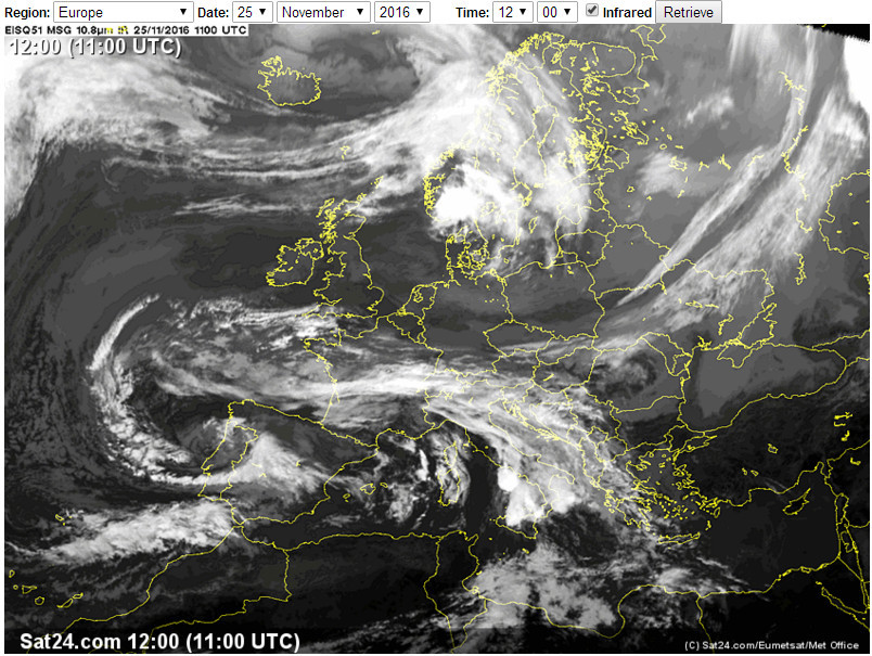
Here ya go… 1200Z on the day:
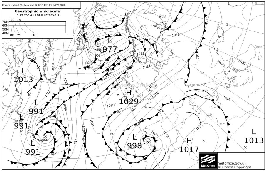
12hrs later:

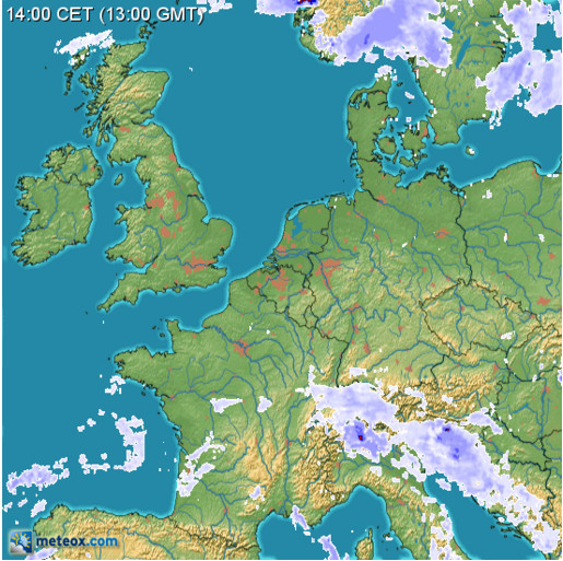
25/11/2016 meteox.com – wx near Annecy doesn’t look good. Whenever a cold front turns into a warm front (see the uppermost MSLP chart, near Annecy) you get bad wx.
sat24.com:
The white bit in the east-middle of France is just a thin cloud layer c. FL300. I flew under it c. 1200Z.
Shorrick_Mk2 wrote:
FR24 quotes transponder altitude based on standard 1013 QNH not actual altitude
Thats right, but QNH in Chambery was 1014 on Friday 13:30. This is only a difference of about 9m. Look here:
http://www.vakw.ch/metararchiv.html
Weather for Annecy (1521 ft elevation):
LFLP 251400Z AUTO 00000KT 9999 OVC052 11/07 Q1014 NOSIG
LFLP 251330Z AUTO 08003KT 040V110 9999 OVC052 10/06 Q1014 NOSIG
LFLP 251300Z AUTO VRB01KT 9999 OVC054 10/06 Q1014 NOSIG
LFLP 251230Z AUTO VRB02KT 9999 OVC050 10/06 Q1014 NOSIG
LFLP 251200Z AUTO 00000KT 9999 FEW021 OVC045 10/06 Q1014 NOSIG
Would indicate a ceiling at around 6500 ft AMS, with possibly lower cloud around.
Weather at Chambery: (779 ft AMSL)
LFLB 251430Z AUTO 17005KT 9999 FEW052 12/08 Q1014 NOSIG
LFLB 251400Z AUTO VRB01KT 9999 BKN054 BKN066 13/08 Q1014 NOSIG
LFLB 251330Z AUTO 00000KT 9999 FEW068 BKN110 12/08 Q1014 NOSIG
LFLB 251300Z AUTO VRB01KT 9999 BKN068 BKN120 11/08 Q1014 NOSIG
LFLB 251230Z AUTO 16004KT 9999 FEW056 BKN068 BKN100 11/08 Q1014 NOSIG
LFLB 251200Z AUTO VRB02KT 9999 FEW021 BKN074 BKN110 12/07 Q1014 TEMPO 4000 RA BKN014
Would indicate a ceiling at around 7500 ft AMSL.
These are autometars, so while the actual values are probably right, the coverage has a big question mark. BKN to OVC is likely fromt the synoptical side however.
Both of these are some distance of the crash site and there is a “slope” visible in the two METARS of roughly 1000 ft between Chambery and Annecy, indicating that the ceiling in MSL sank towards the mountains. That would be what I expect in such a met situation. We have no ceiling information for Albertville. It is very likely that at the FR indicated altitude they were below the ceiling and decided to cancel, thereafter went for a direct track to Albertville, in which way the crash site lies. With the slope of the ceiling between Chambery and Annecy, I would not rule out that the ceiling was much lower at Albertville.
Looking at the last radar return and the position of Albertville, it appears at first glance that they proceeded direct, not following either valley but going over the mountains. The crash site is almost on a straight line between the last radar return and Albertville. Clearly, we don’t know much but what it looks like is a CFIT in IMC, possibly in something which looked ok but wasn’t.
This one does hit home… yet again. I’ve never met the pilot but I heard of him. Not sure if he posted here, but certainly someone with ample experience. I’d hesitate to connect this with the “Dangers of flying an SEP” because if it was what it looks like, it could have happened to a twin or even a jet with the same likelyhood, not the first nor the last I fear to end up in a hillside.
My condolences to those who knew him and his FI and to his family.
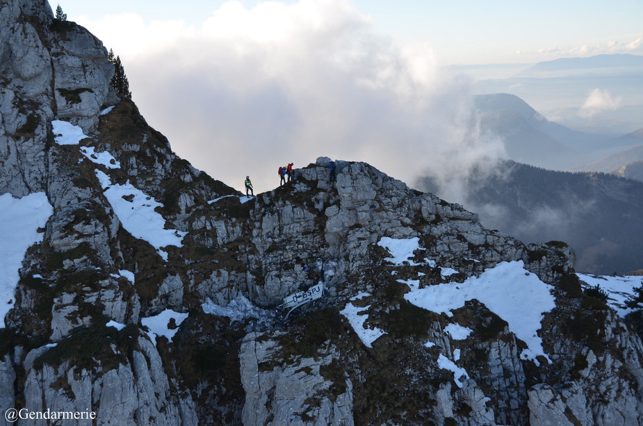
I just found a picture of the crash site in a Swiss newspaper:
http://www.lematin.ch/monde/deux-morts-crash-avion-tourisme/story/30064119