dublinpilot wrote:
VFR pilots are more determined to stay well and truly out of the cloud because they don’t have the skills to get themselves out again if they don’t pop out again when expected.
With a high cloud base (above the top of the mountains), I really don’t think there is much difference. VFR and IFR pilots are equally likely to skid the cloud base. Flying like that with a low cloud base (below mountain tops and into the balleys) is just stupid, and I can’t imagine anyone doing it. You lose every bit of visual references to the ground. There are no horizon in such cases, just the valleys, and to see where the clouds base meet the valley, and to see where the valleys lead, you have to be well below the cloud base. You will automatically position yourself “in the middle”, unless you have way too much confidence in your synthetic terrain models. IMO skidding the clouds in situations like that is more of an erratic panic behaviour.
What does the 6500 refer to?
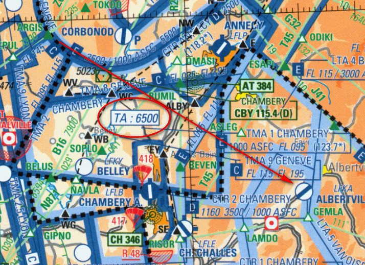
It is positively begging for someone to cross there at 6500ft.
These chart related mistakes are easily done, if you don’t know a key piece of “local knowledge” e.g. as mentioned before in 2004 I flew from France to Switzerland, VFR, just below the cloud, and found the hills 3.2x higher than I expected – the maps used metres! (They used feet also but only for spot elevations, IIRC). I have read accounts in the 12 years since from other pilots getting caught by that. One of them was a high-hour MEP pilot (famous on the UK scene) with bizjet time from years back and an ATPL; his view was that it must have killed a few people.
Peter wrote:
What does the 6500 refer to?
Transition Altitude..
Peter wrote:
What does the 6500 refer to?
The SIA map legend says “Transition altitude different from 5000 ft. TA is fixed within TMA only”
Peter wrote:
It is positively begging for someone to cross there at 6500ft.
Well, there you are…. to maybe work out what might have happened one needs to put oneself in the position of the other pilot, visiting from another country, not a local expert.
Almost nobody reads the map legend, in any country. It’s like reading Notams 
Also almost nobody uses the Jepp IFR Low charts anymore. Not in the last 5-8 years. They have very little use in a modern cockpit and modern routing tools. They are still used in IR classes because they are run on a 1970s syllabus. I do however remember the nonstandard chart scaling from the IR ground school. Fortunately no IR pilot does route planning on paper IFR charts today.
I also think it is strange to print the TA on a VFR chart, especially one which is already so cluttered it is almost useless, with most terrain elevations of mountains having had to be removed because it was already so cluttered.
Peter wrote:
Well, there you are…. to maybe work out what might have happened one needs to put oneself in the position of the other pilot, visiting from another country, not a local expert.
Peter wrote:
it is strange to print the TA on a VFR chart
But this 1/1 000 000 chart is not sold as a VFR only chart. Technically, it is supposed to depict AIP between SFC and FL195. So there is IFR stuff, such as airways, IFR intersections…
The IGN 1/ 500 000 is sold as a VFR chart.
But I don’t think we know for sure which charts the crew was using ?
Hopefully they will find bits of the paper on the ground.
Somebody ought to contact the investigators and tell them. Based on some reports I have seen, the BEA is nowhere near as thorough as say the UK AAIB.
Knowing Stefan, I am fairly sure he didn’t use one of the Ipad VFR moving map products, and definitely not one running a real “printed” chart which would clearly show elevations (because getting that is a rather “anorak” thing, involving mostly bootleg charts, and he wasn’t an “IT anorak”). He was a “jet style” pilot mainly – you plan a flight IFR and you execute it with the panel mount kit because it is 100% adequate (I do the same, with exactly the same kit he had). Well… that can’t be done with Albertville…
TA for VFR has it’s uses as a VFR is supposed to fly in FL (std altimeter instead of local QNH) above TA within the lateral limit of a TMA.
But this 1/1 000 000 chart is not sold as a VFR only chart. Technically, it is supposed to depict AIP between SFC and FL195. So there is IFR stuff, such as airways, IFR intersections…
The IGN 1/ 500 000 is sold as a VFR chart.
I hear what you say (a daft UK lawyer expression) and yes a lot of stuff is published to comply with the ICAO info publishing requirements and not to be actually usable by pilots (like nearly all AIP terminal charts  ) but the IGN and SIA intentions you mention aren’t the reality as perceived outside France.
Also the SIA shop (can’t get closer to being the French Govt itself – it has “French Republic” at the top and “VFR” all over the page) sells the SIA as a VFR chart
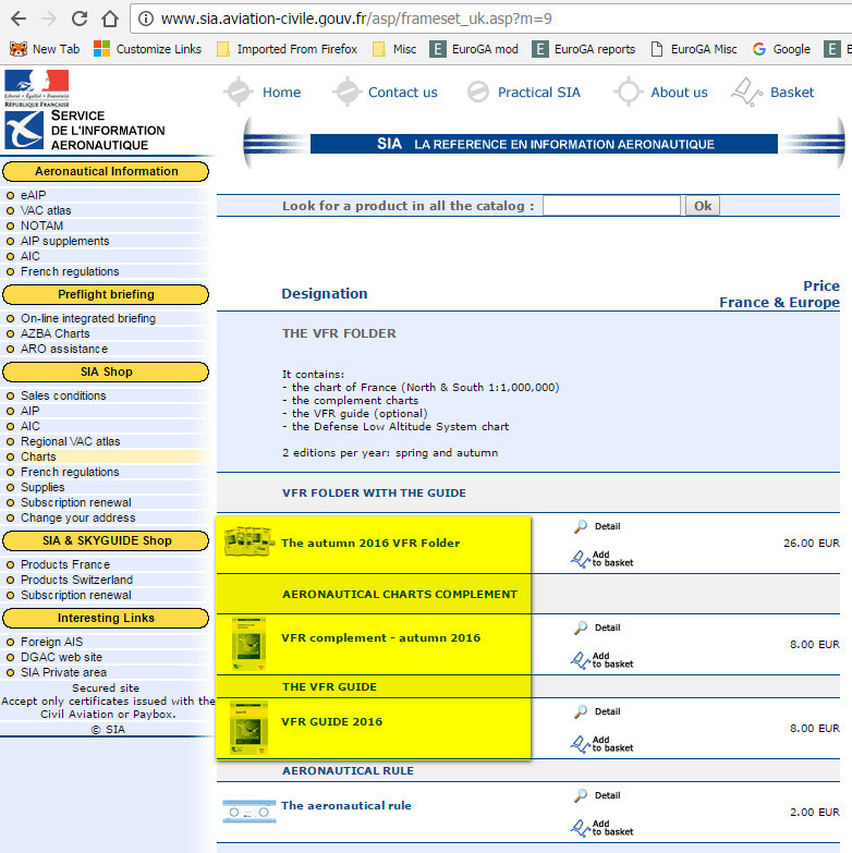
I know; I bought them for years
In all the time I have been flying, the SIA chart was used by most “real” pilots outside France because the IGN ones went up to 5000ft only which everybody outside France laughed at… I realise why IGNs were like that… French club GA is probably 99.9% below 2000ft, except for a few which pop up on FR24 in the Alpine areas and they will know what they are doing. But for years almost nobody outside France would have used IGNs – a 5k AGL limit is a joke. That limit went away fairly recently so one would use the IGNs now (and I too have them running as a moving map, with someone having laboriously downloaded them one tile at a time…) and forget the SIA ones totally.
Also the SIA chart carries the IFR intersections which most long distance pilots plan their routes on. That has been the reality of long distance VFR flight ever since GPS came along. Almost nobody doing any distance navigates using ground features and certainly not people who have an IR/IMCR.
I didnt know the pilot, and of course it is incredibly sad when this happens to one of our own.
The discussion is very interesting and worthwhile but I worry a little about its line.
Any operations in or just above the terrain require familiarity, skill and mechanical reliability, because when things go wrong the margin is inevitably very small.
I think it means whatever kit you are using it is extraordinarily easy to make a mistake and find yourself going up the wrong valley, being slightly low or momentarily distracted by some event, especially in poor visibility. Partial loss of power, or other mechanical issues, never mind how distracting they might be when you are already operating near the margin, become a threatening event.
None of this is meant to be directly attributable to this accident, or in anyway to question the skills of the pilot or what may or may not have happened. However I do feel that whenever we fly “in” the terrain it becomes almost academic what happened, because whether it becomes a misreading of charts, CFIT, or mechanical failure they are all risks that have to be carefully managed. The thought of following any chart, electronic or paper, or totally relying on any electronic means of terrain avoidance on the fly is beyong the ability of most.
Firstly my condolences to you Peter and all of the friends and acquaintances the crew of D-ESPJ have here.
I have read all of this thread and believe that Neal really found the most likely suspect.
After investigating archived articles I can confirm that there was indeed a strong Foehn situation in the Alps.
During PPL training in Switzerland we probably get taught a bit more mountain flying than in other countries for obvious reasons.
One thing I remember is the warning: “don’t ever get near the Alps in a Foehn situation.”
From looking at the picture of the crash, observing the shape of the ridge, and comparing with my own experience of being on the downwind side of such a nasty ridge, I can almost depict what must have happened:
They approached the ridge from downwind at a significantly higher altitude, feeling safe. If they were in IMC they may have not seen the ridge at all on the map, just terrain below them, so they did not imagine the threat.
A powerful rotor “jumped” on them and slammed them down. Imagine a gigantic rotating brush as in a car wash system, laying horizontally on the ridge
The whole thing may have lasted less than 5 seconds.
In VMC, a very experienced pilot with suitable preparation might have had a small chance of executing an evasive maneuver that he had rehearsed, but in IMC, no way.
Foehn rotors will bring down any plane.
When I cross a ridge, I always do the following:
- determine wind direction and strength (thank you G1000!). Never cross from downwind to upwind, even if this means a bid detour.
- approach at an angle that allows escape and mentally rehearse how I will exit if needed.
This is straight from PPL training.
It happened a few times that the wind vector suddenly jumped by 10-20 knots with a direction change as we approached. No go.
I find the strong wind possibility unlikely because the MSLP shows almost no wind
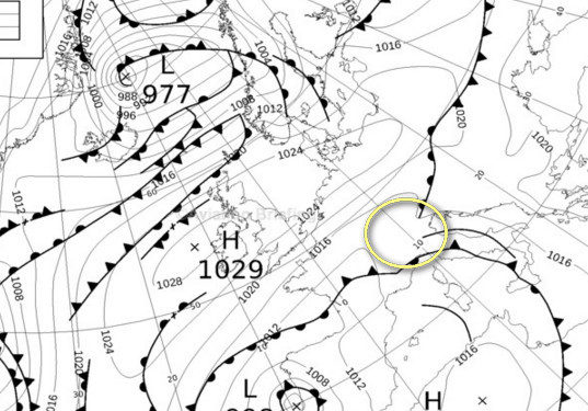
and the metars posted earlier also show almost no wind.
Also the GS from the FR24 track, during level flight, shows ~ 140kt which is consistent with a TB20 in cruise in still air.
Can you really get sudden strong winds locally, when the MSLP shows almost nothing? I have overflown the Alps many times and never seen such a thing, and at a few k feet above the terrain have never had any significant turbulence even with a 30-40kt wind flowing across the terrain (well, at my cruise level, anyway).
What concerns me is the wx radar, which corresponds pretty well to the trough in the MSLP
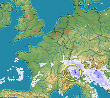
which shows some big dense buildups.
I am pretty sure they were in IMC so one could argue that VFR in IMC is never a good idea (and on an IFR flight one should fly to VFR-only airports fully IFR (which usually means VMC on top) and if upon arrival in the vicinity it is found to be under cloud, then one must divert, etc) and one could thus argue that any confusing VFR chart is a side show, but that wouldn’t help with trying to understand what happened.