
I recall from some IR theory that with an IFR airport the ARP is supposed to be the middle of the principal instrument runway, but obviously this is wrong e.g.
If you set DCT LFLX, do you get the middle of the runway or the ARP?
A DCT to LFLX will in go towards the ARP.
See also: http://www.ngs.noaa.gov/AERO/arpcomp/arpframe.html
For whatever reason, if there is one runway, it is often just to the side of it.
Oddly enough that link starts with “The Airport Reference Point (ARP) is the approximate geometric center of all usable runways” which in the one runway case should clearly be the middle of that one runway 
The ARP is not always at “the approximate geometric center of all usable runways”.
This is the ARP for ESMS Malmö. If you put in Direct to ESMS in a GPS then it guides you to the ARP, it does not guide you to any runway.
When the airport was built it there were plans to add more runways sometime in the future. I’ve heard that the ARP is placed so that it will be in the center if/when the additional runaways are built.
Correct. Dubai World is also like that with the ARP being about a 1.5nm North of the only runway. Can be a bit of an eye-opener for those who program their GPS with a DCT and an OBS when the visibility is a bit poor.
(Yes, I’ve seen it done).
I do DCT [airport] when flying an ILS, just to get the magenta line as a rough reference for where the localiser lies, so I know when to expect the intercept.
Fairly obviously it would be better to do a DCT [some NDB or VOR close to the runway].
Do that at Dubai World and you’ll never find the ILS! :) I tend to do DCT the localiser.
What waypoint would you use for the LOC?
(KLN94 )
Peter wrote:
Fairly obviously it would be better to do a DCT
Depending on your database you can enter DCT runway XX which will guide you to the threshold with accurate distance reading (these waypoints will always be coded if there exists a GPS approach) or DCT to the identifier of the localiser, which would be “CX” for runway 21 in your example above. The distance readings will be relative to the position of the localiser antenna, but the lateral guidance will be spot on.
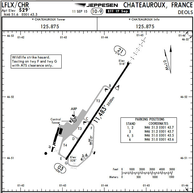
The ARP stays in place when runways are withdrawn. LFLX was a busy USAFE base, so presumably there may have been other runways, now long disused and redeveloped for other purposes. DXB has been extensively redeveloped too.


