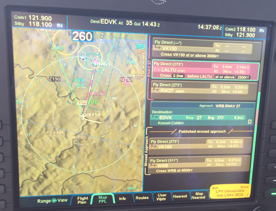
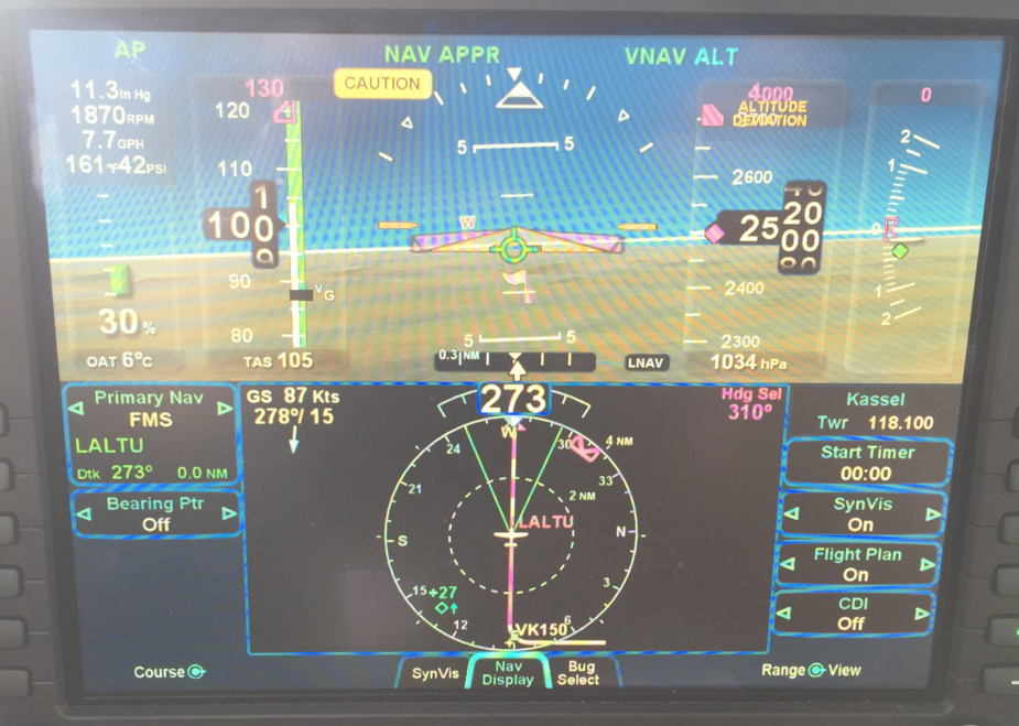
During my approach yesterday at EDVK I got a message telling me that LPV is not available and the system switched to LNAV. It was VMC so not a big thing.
Does anyone know where to find historic RAIM data?
LPV does not use RAIM but EGNOS/WAAS.
RAIM availability, even history I believe, is available from AUGUR (search Eurocontrol AUGUR)
But LPV doesn’t need RAIM, at all, does it?
What could cause LPV to go “out”?
The GPS has no way of knowing that LPV is not available, other than the EGNOS signal being duff.
If RAIM was not available, the LNAV approach would not be presented either, AFAIK… (not sure about that, but it’s certainly not legal to fly an LNAV approach without RAIM).
I can see suppressing an LPV approach if EGNOS is not available but it would be highly dangerous to suppress an LNAV approach if RAIM is not available, since it might be the only chance of saving the pilot’s life.
But LPV doesn’t need RAIM, at all, does it?
Here is what the DGAC Guidelines for RNP Approaches says:
To make an APV SBAS (LPV) approach, no RAIM prediction is required, because integrity is managed
directly by the SBAS geostationary satellites.
If RAIM was not available, the LNAV approach would not be presented either, AFAIK…
Indeed. Here is what the G1000 manual says:
The G1000 automatically monitors RAIM and warns with an alert message when it is not available. If RAIM is not
predicted to be available for the final approach course, the approach does not become active, as indicated by
the messages “Approach is not active” and “RAIM not available from FAF to MAP”. If RAIM is not available
when crossing the FAF, the missed approach procedure must be flown.
I can see suppressing an LPV approach if EGNOS is not available but it would be highly dangerous to suppress an LNAV approach if RAIM is not available, since it might be the only chance of saving the pilot’s life.
When you fly an LNAV approach you must always have an “out” in case you loose RAIM unexpectedly.
LPV gets downgraded to LNAV if the horizontal and vertical protection levels are not below 50ft (I think from memory). It has nothing to do with RAIM although if GPS signals are poor that could cause it along with RAIM failures on non WAAS systems.
In my experience it is usually caused by reception issues with the WAAS or EGNOS satellites ie you aren’t receiving the correction data. This can be caused by GPS almanac issues in the unit or just bad luck.
LPV gets downgraded to LNAV if the horizontal and vertical protection levels are not below 50ft (I think from memory).
With an DH of 250 ft or greater, Vertical Figure of Merit (VFOM) needs to be less than 60 ft for LPV or there will be a downgrade to LNAV. For a DH less than 200 ft the VFOM needs to be less than 40 ft.
LPV gets downgraded to LNAV if the horizontal and vertical protection levels are not below 50ft (I think from memory). It has nothing to do with RAIM although if GPS signals are poor that could cause it along with RAIM failures on non WAAS systems.
In my experience it is usually caused by reception issues with the WAAS or EGNOS satellites ie you aren’t receiving the correction data. This can be caused by GPS almanac issues in the unit or just bad luck.
Your memory is almost correct, the VPL limit is 50 meters, not feet.
As you and others indicated, an SBAS GPS does not use RAIM for integrity monitoring when the SBAS (EGNOS) signal is available and one is operating inside the EGNOS service volume. When operating outside of the SBAS service volume or when there is an SBAS system failure, the GPS will default back to RAIM for integrity. Usually a downgrade from LPV service to LNAV service occurs when VPL or HPL fall below the criteria, but the EGNOS signal is still providing the integrity data. Loss of EGNOS is a totally different issue and means that the entire system is down, in which case the GPS reverts to RAIM and only LNAV integrity might be available, depending on the GPS satellite geometry. Loss of WAAS in North America is an extremely rare event as there are three Geostationary satellites and only one of them needs to be operating to provide WAAS for most of North America. The SBAS satellites are the ones numbered above 32 on the satellite page. In North America, two of the three also broadcast a ranging signal in addition to the SBAS correction and integrity data. These appear as additional GPS satellites on the satellite page of the GPS. If the SBAS satellite is not providing a ranging signal, you will still see the satellite bar on the GPS satellite page, but it will be hollow and not colored in.
When the integrity falls below either HPL (40 meters) or VPL (50 Meters), no vertical guidance will be available and a downgrade from LPV or LNAV+V to LNAV. All downgrades are to LNAV and occur when the aircraft is on the approach and 1 minute to the FAF. The relevant HPL and VPL are not displayed on most GPS systems. The current TSO requires that HFOM and VFOM be displayed to the pilot. These are measured in feet. They are loosely related to HPL and VPL and a VPL of 50 meters is roughly the same as a VFOM of 60 feet. When an approach is loaded, if the integrity is below the limit, the LPV annunciation will be amber instead of green. This should give the pilot an advance warning of a likely downgrade at the 1 minute point.
Since the HPL required for LPV is tight at 40 meters, it is not always available. This is particularly possible during a solar storm. However, the LNAV maximum HPL of 556 meters is rarely ever breached and for all practical purposes is always available.
Today I was able to try out the RNAV 27 LPV at EDVK. Just as last Saturday I got the message about LPV not being available.
EDVK Tower didn’t know about any issues with EGNOS or the approach. I’ve sent the question to Avidyne as well.
I still need to process the detailed information given by NCYankee and others but I wanted to share what I’ve learned so far.
Maybe your R9 cannot handle EGNOS? The first IFD540 units had that problem.