Yes, though I have never seen ISA minus anything of substance.
I was in Innsbruck this winter at approx. ISA-20; they closed the lowest level because of the low temperature.
With regard to the accident that raised this thread, the airport of destination was LIMZ (which is very close to LIMG). The apparent accident track is generally on a direct line between the two airfields, right at the Eastern edge of high ground. I think the IFR route would go via LAGEN (which is a large dog leg (175%, but only about 30 miles given the very short distance).
There is possibly a route ABN/N0175F130 IFR DCT (climb VFR to join the ABN arrival), which would take the aircraft over what appears to be the crash location.
I made a similar flight from LEAX to LEGA and the controller's initial instruction was to proceed up the mountain, terrain hugging until I got to the IFR join point on top of the mountain. My performance isn't good enough to out climb the mountains even in VMC (and the cloud deck was about 3000 -FL100), so I requested and received about 5 orbits to climb in place until above the mountains. What was very irritating in my case was I had flight planned out a valley and then back in on another valley, but eurocontrol kept amending the plan to the 'over the mountain' one!
NOTE - my statement of destination LIMZ is based on the press report saying the aircraft was tracking towards LIMZ,
Many thanks for that input, mm_flynn.
Do you think the climbout may have been performance limited?
I had a TAWS warning on approach to Albenga rwy 27 while on the LOC DME.
What TAWS produce is that?
What TAWS produce is that?
While it comes up on the Garmin, I think it is actually a Honeywell TAWS-B product. There is also terrain on the G1000 as it warnings appear in SynVis etc.
The Honeywell TAWS box is rare and hugely expensive - it costs about £25k.
You have database updates on top of that.
I know of two pilots who had it in their TB20s and it reportedly worked well.
Yes it seems it is the standard Piper fitout for the Pa-46. The KMH-880 Box is very good.
I don't have a GPWS, but I do have the terrain feature on my GNS530W. The main difference between the terrain feature and TAWS (other than $8000) is that the latter has audio warnings and adds the 500 foot call out. They use the same databases. Since the mountains don't move much (Mt St. Helen excepted), I only update the obstacle database about once a year. Occasionally, I will display the terrain page for an approach or departure,
This was why I used the G496.
The 296 has the same function AFAIK but it won't output the warnings on its audio output, which makes them useless.
A bit like a car satnav which has the speed cameras in the database but with no audio warning 
However I would be suprised if any GA GPWS system gave you a warning (other than the "you are about to die" one from a RADALT) if you are departing on a SID and "merely" not making the specified rate of climb.
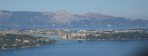
This is an approach into Kerkira (Corfu) LGKR
If you depart in that direction (there is a SID) there is no warning from the G496.
Fortunately even a TB20 can outclimb that hill, but something lesser won't.
I don't have a GPWS, but I do have the terrain feature on my GNS530W.
At work we have EGPWS and when instructing (which I consider rather a form of recreation) we have GNS430/530 with terrain feature. I prefer the GNS because the display is much better and shows also obstacles.
Over the years have encountered two problems with GPWS. One is, that the database gets updated only once per year. Terrain dosen't change much, but airports do. When Frankfurt got it's new northern runway last year, our GPWS shouted at us on every approach (until it was finally updated). Some EGPWS warnings can be disabled by pressing a button, but not this one. So pulling the CB was the only remedy - which usually is a violation of operating procedures.
The other problem is that in many cases only aircraft performance - and a lot of it - can save you once you get your GPWS terrain warning, especially in mountainous environments. So unless you have that performance on hand, all that GPWS will do for you is to announce your imminent death. Having a permanent terrain display in your field of view like on a Garmin unit is much better, because it will show you much in advance what's going to come and where possible escape routes might be.