
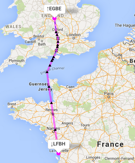
As you know, I’ve just passed the IR, licence is not back yet. This weekend weather dependant I am going to La Rochelle (LFBH) VFR, San Sebastian proved too much hassle at the moment. Now, whilst the IR training was good, it taught me to pass the test and not necessarily to go anywhere. I had a little play with Autorouter EGBE to LFBH, and it gave me several options.
This is the IFR to IFR option (which is the one I would presumably want if going IFR?)
EGBE N0173F090 KIDLI N859 CPT Y321 PEPIS Q41 THRED/N0172F080 Q41 ASPEN/N0170F060 Q41 ORTAC DCT KETIK DCT DOLDE DCT RS DCT ABLAN/N0169F050 DCT YN LFBH
Now my query is, I thought IFR Flight plans need to end at the IAF and not the Airport? There is another option that ends in a STAR, but I cannot find the Star in the AIP Instrument Approach.
Rob2701 wrote:
This is the IFR to IFR option (which is the one I would presumably want if going IFR?)
Looks like a good route, the DCTs in the UK are all blue/magenta dashed which means they’re on a NATS approved standard route.
Now my query is, I thought IFR Flight plans need to end at the IAF and not the Airport?
This is just a convenience formatting of autorouter. What you are talking about is item 15, the route and this does not include the destination airport. You can see it under “Briefing information”. YN is your connection point to the airport, according to Eurocontrol rule LFBH51610B, any waypoint within 50NM of the aerodrome can be used as connection point.
Rob2701 wrote:
There is another option that ends in a STAR, but I cannot find the Star in the AIP Instrument Approach.
autorouter generally favors SID/STAR over DCT connections even when they are substantially longer. They should be published, which one were you unable to find? Sometimes Eurocontrol has SID/STAR that are not officially published and they are not always flagged to be avoided. It’s a rare case though.
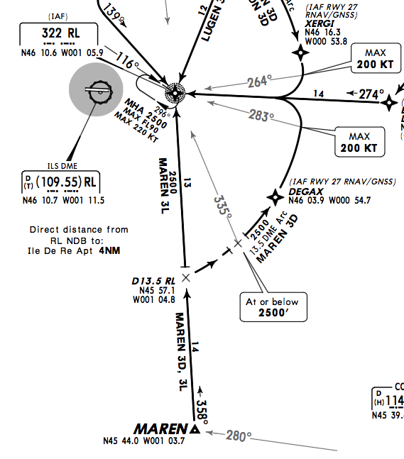
When I try to route, I get MAREN3L as STAR which is published. Of course MAREN3L is rather inconvenient as RL is overhead the airfield so you have to turn back and intercept the final. ATC will vector you.
I would fly at FL100, that gives you a lot more airway time in the UK. Always good in that weird system where you are always threatened with the “contact London information” middle finger 
EGBE N0147F100 KIDLI N859 CPT Y321 PEPIS Q41 ORTAC DCT KETIK DCT DOLDE DCT RS DCT ABLAN DCT YN/N0138F040 DCT RL MAREN3L LFBH
If you were to write the plan out manually, would you not end the route at RL (NDB) and then fly the procedural ILS if a radar vectored ILS was not available. Also, the MAREN3L takes you 27 NM south, is there not a STAR to use when approaching from the North?
Rob2701 wrote:
If you were to write the plan out manually, would you not end the route at RL (NDB) and then fly the procedural ILS if a radar vectored ILS was not available.
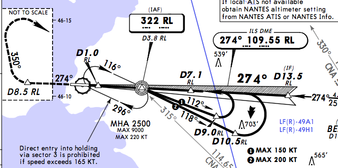
Yes, the enroute segment (item 15) ends at the IAF which is RL in this case. The MAREN3L STAR is coded by Eurocontrol in a way that you jump onto it at RL which kind of eliminates it altogether. You can see on the Jepp chart that MAREN3L goes via RL and RL itself is an IAF which causes this odd scenario.
Rob2701 wrote:
Also, the MAREN3L takes you 27 NM south, is there not a STAR to use when approaching from the North?
Because it is not entered at MAREN. If you want another, you can choose so when you calculate the routing, next to the destination aerodrome click on STARs and add the LUGEN STARs to the list. Then you get this at FL100:
EGBE N0147F100 KIDLI N859 CPT Y321 PEPIS Q41 ORTAC DCT KETIK DCT DOLDE DCT RS DCT ABLAN DCT YN/N0136F030 DCT RL LUGEN3D LFBH
So again you skip LUGEN and jump onto the STAR at RL (that’s the way it is coded). It’s not uncommon for STARs to multiple entry points and SIDs to have multiple exit points. If you really want to fly by LUGEN, you make it a fly-by waypoint (while keeping LUGEN3D/3L as STARs) and get:
EGBE N0147F100 KIDLI N859 CPT Y321 PEPIS Q41 ORTAC DCT KETIK DCT DOLDE DCT GOMDA DCT NEDAN DCT RALIX DCT LUGEN LUGEN3D LFBH
If that makes you happy, use it! However, it’s completely irrelevant as you will be radio vectored. If France wanted you to use STARs to their full extent, they would code them differently like they do e.g. in Paris.

They don’t teach you all this your IR training.
Yes, but they teach you how to fly an ILS in IMC. That’s important. The rest you can easily learn as you go.
Back when we started, there were no tools like autorouter
Rob2701 wrote:
If you were to write the plan out manually, would you not end the route at RL (NDB) and then fly the procedural ILS if a radar vectored ILS was not available. Also, the MAREN3L takes you 27 NM south, is there not a STAR to use when approaching from the North?
If you insist on a STAR, you could do ABLAN DCT LUSON LUSON3D which would be perfect for ILS27.
My personal preference is to avoid to file directs if possible. In your case I think ORTAC DCT DIN A25 LUSON LUSON3D should work. You end up with a slightly longer flight planned route, i.e. your required fuel on board is somewhat higher, but it causes less head scratching in the ATC end. Sometimes DCT is extremely useful. In your case you could hardly do without to get from ORTAC to DOLDE or DIN
In any event, during the flight you will get directs, and if you think there is a worthwhile shortcut, do not hesitate to ask for it. You may not get exactly what you asked for, but at least the controller will make an effort to give you something better if he/she can.
On my way back from Carcassonne in June, due to stronger headwinds than planned, the FMS showed that I would reach my destination (LFPT) with less fuel than what I needed for my alternate + minimum reserve. After having asked for a shortcut on the STAR, my fuel situation got back where it should be.
I would also add that as you are approaching what sounds like the last radar controller on your flight, get the destination ATIS (most conveniently done when you are handed over to the next frequency, because nobody will be bothering you for a minute or so) and when you call him up, say you want a radar vectored ILS for [the current runway as per the ATIS].
I don’t recall whether La Rochelle does the radar vectoring for itself.
Never fly a procedural (called “standard” outside the UK) approach. Nobody does it except during training. Always ask for radar vectors.
But be ready to fly the published procedural approach. The last waypoint of your filed route will tell you which STAR to look up.
Aviathor wrote:
My personal preference is to avoid to file directs if possible.
Why is that?
He was talking about DCT airport connections. autorouter has a preference for STARs as well. Easier to prepare, there is usually no guidance on how to do a DCT connection from the last enroute waypoint to the airport. There could be restricted airspaces, uncontrolled airspace, etc.


