The older streams are well documented e.g. the Bendix/King “aviation” data stream which comes out of a KLN94. Similarly the GNS430/530 one is documented in the IMs.
But not the one which comes out of a GNS430W or later.
It must exist otherwise e.g. Avidyne could not have made their IFD boxes Garmin plug-compatible.
Many thanks in advance for any tips or info – by PM if you prefer. It is for a little project I am playing with, not anything commercial.
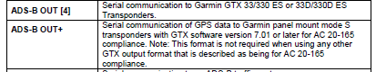
The aviation data is not changed for the GNS430W/530W. There are other proprietary RS232 data streams for ADS-B Out, most useful is the ADS-B Out +. Garmin has licensed the interface to other manufacturers and some have reversed engineered it. There is also a standard ARINC 429 protocol that is public for ADS-B Out, using ARINC 473 data stream.
Indeed; I did find the “aviation” data stream in the 530W IM also. That would be the standard one.
It is the ADS-B stream I am after, such as required by a TAS605A.
I can also generate ARINC429… can a TAS605A accept ARINC429 GPS position, and where can I find the protocol spec?
I suspect that while the RS232 stream quite likely contains some “crypto” (a checksum or CRC) this is much less likely to be found in an ARINC429 stream which uses defined packets and labels.
EDIT: I found this in the TAS6xxA IM:
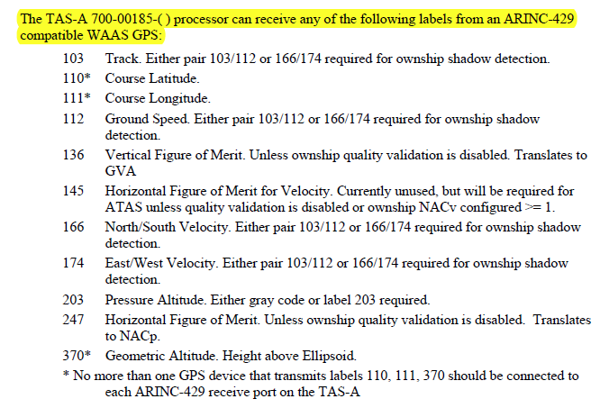
That must be it, but there must be a spec somewhere for the data format…
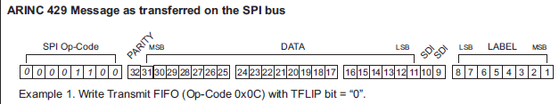
I have made some more progress but only on the ARINC429 approach. I have not found anything recent enough to be from the ADS-B era but this example document shows the use of the labels
I am now trying to buy an ARINC429 to RS232 (or USB VCP) converter for examining some data streams which I have, to learn more, but they cost best part of 1k. I found one for £200 but it is discontinued.
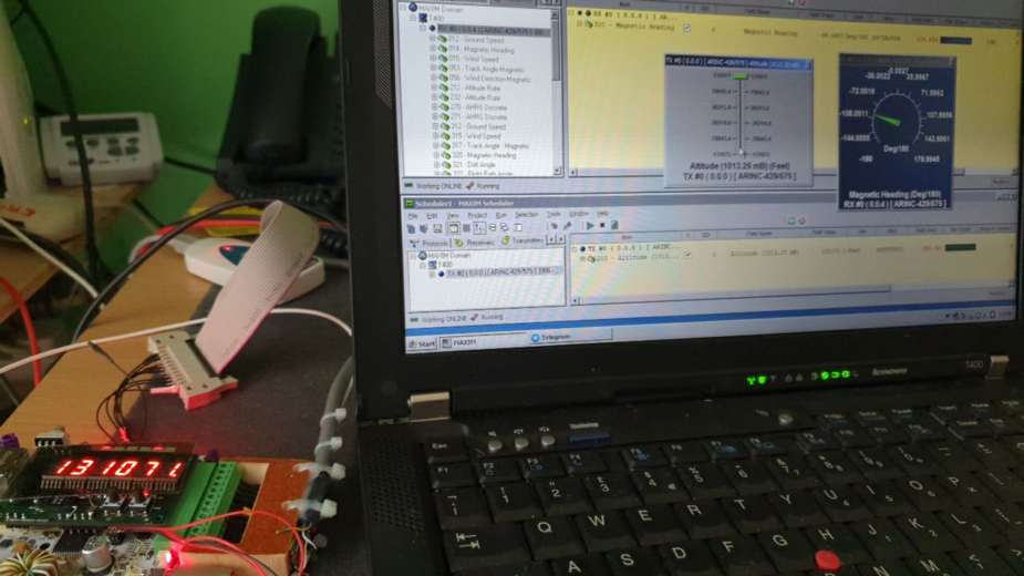
I am now successfully decoding ARINC429 coming out of a spare SG102 AHRS.
The code is messy. This is the Label 320 (mag heading) description
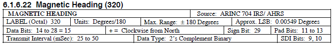
The label is encoded in octal  but that is only a part of the fun. The bit numbering is, ahem, unusual
Next I need to borrow something which generates a pressure altitude and a GTX330 would be ideal. Then I will need something which outputs WAAS GPS position. Would a 430W do that?
I did find a PCMCIA card on Ebay in Germany for about 150 quid but could not get it to do anything, but managed to work it out anyway with the help of the SG102 data source.
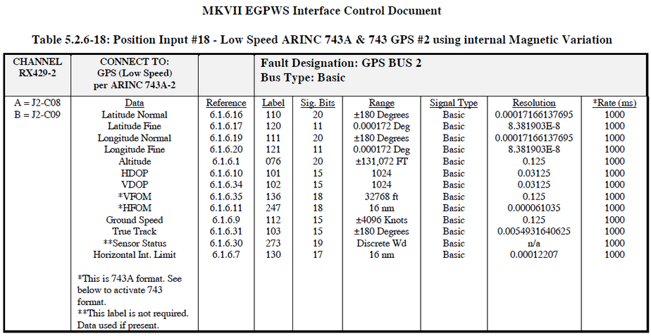
The curious thing is that the TAS605A requires labels 110 and 111 for the position, but a 430W doesn’t list these in its outputs. It shows 310 and 311. So how does a 430W act as a position source for a TAS6xx over ARINC429 ?
Peter wrote:
Then I will need something which outputs WAAS GPS position. Would a 430W do that?
It does, but not in 429. It uses a Garmin RS232 protocol.
The TAS605A interfaces with a GNS430W in RS232 so presumably it’s getting it’s position data from there..
The 429 output labels from a GNS430W are as follows;


Aha that explains why I could find only labels 310 and 311 in the GNS430W IM, and only labels 110 and 111 in the TAS605A IM
One has to use RS232 for that connection, and of course that data stream is “secret”.
There might be a demand for label 310/311 to 110/111 converter 
Curiously the Avidyne navigators also do not output labels 110 and 111, so that connection must also use the proprietary RS232 data stream. I wonder why Avidyne did that, given that they control both ends of that connection?
Does anything out there output labels 110 and 111?
Peter wrote:
Next I need to borrow something which generates a pressure altitude and a GTX330 would be ideal. Then I will need something which outputs WAAS GPS position. Would a 430W do that?
If you like programming, you can build a raspberry pi with stratux build and some SDR and a GPS, it does get WAAS GPS, that you can find in a driver, and easily connect a USB to serial converter. Then the coding job :/
Edit: look at this:
https://github.com/neonbjb/RaspPiArinc429
The Garmin RS232 data stream is probably going to be too difficult.
I have solved it using ARINC429, on which the data cannot be hidden. I am using a PCMCIA ARINC429 card from Ebay and some free software. Here it is generating Label 203 pressure altitude, at high speed just like a GTX330:
For a GPS, one can buy a WAAS/EGNOS compatible module for €20, which outputs NMEA. Then output labels 310/311 or 110/111. Or all of them
The C coding is quite good fun, but laborious because the way each label’s data is encoded is different.