Peter wrote:
For example the US WAAS satellites also do positioning, whereas the European EGNOS satellites don’t.
What does that mean?
The extra position (not correction) signal from EGNOS is near to useless…
EGNOS doesn’t offer positioning, officially. WAAS does.
I first came across this when playing with a “high end consumer” GPS module, which computes a 3D fix with (partially) WAAS sats but not with EGNOS sats.
If the Geo satellite provides a ranging signal in addition to SBAS, it will show on the Garmin GPS satellite view with a signal bar that is filled in. If it does not have a ranging signal, the signal bar will be hollow.
Ibra wrote:
The extra position (not correction) signal from EGNOS is near to useless…
In most cases over the continental US, the SBAS satellites are high in the sky and add up to three additional satellites for position. It makes sense to me that these should improve the vertical accuracy and vertical integrity as the best geometry is for satellites both high in the horizon with some low to the horizon. The SBAS satellites are those with PRN above 32, so 35, 40, and 45 are SBAS in the GTN trainer and they are providing a ranging signal. The D indicates that the signal is also being corrected with the SBAS corrections.

zuutroy wrote:
I’ve spent some time playing with the IFD simulator and I can’t get it to sequence a visual approach properly other than for a straight in. If you do direct to an airport an then activate the visual approach with, say a left base, it will highlight a long final as the magenta line with the base leg a dashed white line and a ‘gap in route’. I haven’t used the IFD much so maybe doing something wrong?
Can anyone figure out how to get this working? I asked on the Avidyne forum also, but no reply yet.
Referring back to the speculation of what level of SBAS – if any I am receiving, here is a screenshot of the IFD550 Satellite status page as I was shooting the RNP Rwy 36 Approach into Lampang VTCL airport earlier today.
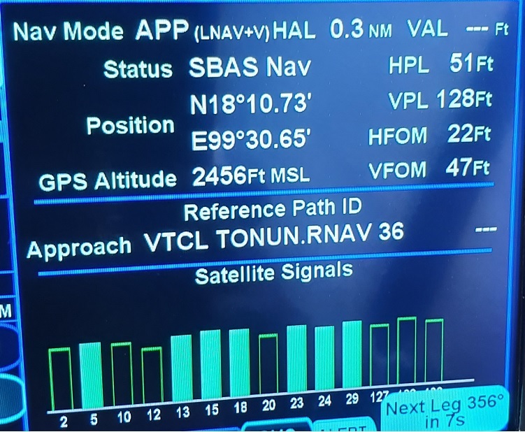
The service level denotes SBAS Nav. I guess this is coming as a spillover from the Indian GAGAN SBAS system, but without the ground station element? Thailand definitely does not have any SBAS ground stations, nor official support for SBAS.
The IFD does not show which SBAS service it is receiving or give any options that I can find to selectively choose one.
RNP Rwy 36 is an LNAV only approach but I did receive a +V glideslope (GS) which I was able to couple with the KFC225 all the way down to MDH.
However on the previous flight, shooting the RNP RWY 32 VTPP which is an LNAV/VNAV approach had mixed results. The IFD indicated it armed the LNAV/VNAV approach and it initially provided a coupled GS which the KFC225 began following down until approximately 500ft above the DA, at which point the GS disappeared and I was only left with Lateral guidance.
Unfortunately at the time I did not have the time to capture the Satellite status page to see what level of service it was providing pre and post GS. I will the next time I try it.
I presume this is due to the lack of ground stations, and the PBN minima no longer being met? If so this is a potentially disingenuous situation, because it actually leaves me worse off than if I just had LNAV+V to MDH.
Ideally I would disable SBAS if this is the case and default all the LNAV approaches to +V.
Cheers – E
From Google: “GAGAN has two Indigenous Geostationary satellites broadcasting the SBAS signals. The satellites are identified as GSAT-8 with PRN 127 and GSAT-10 with PRN 128. Another GEO satellite GSAT-15 (PRN 132)is in orbit and integration with the satellite is in under progress.”
So from your screenshot, it appears you are receiving the GAGAN satellites. More ground stations provide overall better correction, probably mostly for the ionospheric corrections, but are not required to be everywhere in the service volume. The US WAAS system provides for LPV 200 outside of the area covered by ground stations. A VPL of 43 meters (128 feet) is not far from the limit of 50 meters that is required for LNAV/VNAV, but still within tolerance for LNAV/VNAV or even LPV other than LPV 200.
Thanks @NCYankee.
Presumably if the VPL exceeded 50 meters, then vertical guidance would be withdrawn, and the approach downgraded to lateral LNAV only?
Perhaps this would account for what I experienced during the LNAV/VNAV approach previously, being so close to the limit?
If it happens again, I will try to grab the satellite stays page to see what VPL is at that time.
Cheers. E
Doesn’t IFR GPS suppress LOI messages, and may even use internal deduced reckoning, once you are past the FAF? Or is this only on LNAV?