
The. ADL120 looks like brilliant device….
Be aware that the information can be up to 15 minutes old and weather moves..
In the case of thunderstorms it’s not so much that weather moves but rather CBs form and build very quickly in unstable air….another internet product I learned about at the recent PPLIR workshop in Carlisle is Wetterzentrale.de….go to the Topkarten and choose the GFS model and select the CAPE and lifted Index representations….anything with a LI less than zero is cause for a watchful eye…
anything with a LI less than zero is cause for a watchful eye
Autorouter GRAMET prints a TS symbol wherever the lifted index is less than -0.5; in green for -0.5>=LI>-3.5 indicating possible TS, in yellow for -3.5>=LI>-5.5 indicating probable TS, in red for -5.5>=LI>-6.5 indicating severe TS, and in magenta for -6.5>=LI indicating violent TS.
Yes….but if you want a map view rather than just a cross-section the Wetterzentrale site is very good
Thanks a lot for the responses, guys!
I don’t have radar or stormscope on board. Having data-link weather is a huge step forward.
I do understand that you can’t 100% rely on it, as there is a lot of technique involved.
But since it uses an official source (Deutscher Wetterdienst), and the maps are timestamped (so you can check whether the map is current), I consider the downloaded maps to be fairly reliable.
Good advice to retrieve both the strike and the radar maps! Indeed it offers a good way to crosscheck the data.
With version 4 you can now also download on the ground with wifi or 4g.
That is amazing! I was asking Sebastian about this feature about a month ago. He said it would be included in the next release.
I wasn’t expecting it to be implemented so quick! 
I just downloaded the latest version, and noticed another feature which is really cool: the “Minima” map view.
It shows all airports along the route with a color code that indicates the meteo conditions.
See screenshot here
That is a feature which is useful for VFR flyers as well, and makes diversion planning really easy…
I’m planning a flight to Southern Germany tomorrow, and the weather doesn’t look that great. So we will see the ADL-120 in action
Will keep you updated…
With version 4 you can now also download on the ground with wifi or 4g.
Is that implemented with a second SIM card?
I believe Thuraya offer terrestrial access like that, on some phones, if you are on a contract. In fact I think even my old 7100 or 7101 (or maybe just the 7101) phone will do it.
The question is how much you have to pay on a contract to get this? Nowadays most people can get a good roaming data deal on their phone and then obviously you can download anything, much more freely, though not in the seamless manner which you would get if everything was coming down via the ADL120.
Peter it just refers to the iPad app. Nothing to do with the satellite connection. Essentially you can download anything over WiFi/iPad sim card that is normally downloaded over the box.
It’s a nice feature. You can do your weather download on the ground over a WiFi/3G network.
It’s the iPad app that fetches the data, and it works without the ADL-120 unit.
There was an intense rain shower over my house this afternoon, and I checked the ADLConnect App how it was depicted.
It showed yellow/orange, so I now know what to expect when I see that colors 
Today was a great day to see the ADL-120 in action! We went to Speyer (EDRY), to visit the Technic Museum
Speyer is a modern GA airport. The museum is right around the corner.
It was very hot day, with a lot of convective weather.
The weather for the return flight looked quite interesting. There was a cold front moving to the north-east.
This was the TAF for Amsterdam:
TAF AMD EHAM 061248Z 0612/0718 18016G26KT 9999 SCT020 BKN040
         TEMPO 0612/0618 6000 RA SHRA SCT020CB
         BECMG 0613/0615 29014KT
         PROB40 TEMPO 0614/0616 19022G35KT 3500 TSRA SCT015 BKN020CB
          BECMG 0619/0622 23007KT
         PROB30 0702/0708 6000 BKN006
         BECMG 0712/0715 29008KT=
We picked our alternates carefully, and decided to launch, staying in VMC as much as possible and use the ADL120 to strategically route around weather.
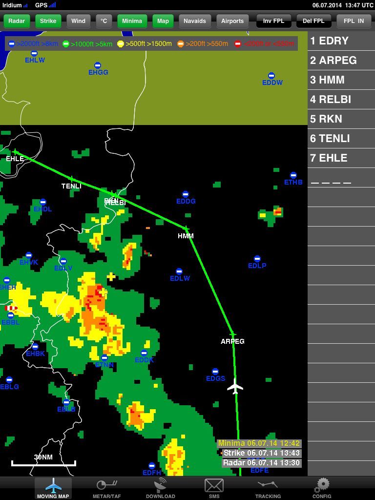
This was the radar picture of the return flight:
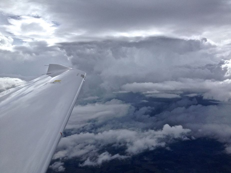
This is how it looked from the left window:

Since the front was moving to the NE, it was obvious that we would get into the nasty weather after the HMM VOR, where our route would take us to a more western course.
I told Langen Radar that we need to deviate to the north around the weather, on a heading of about 340 after HMM, up to EHHO (a grass airfield further North in NL).
That was approved, not a problem at all…
More nasty stuff you better avoid
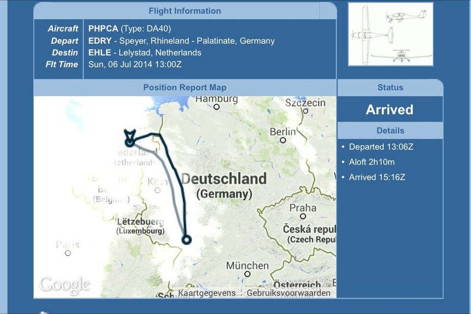
Approaching our destination. We successfully routed around the weather.

Actual track versus planned:
Only german but also a good example for the use of adl.
I’ve sent them an email asking if the product can use an Antcom rooftop antenna which I already have installed (Iridium/Thuraya + GPS) and whether they have a windows app of any kind (my tablet is win8).


